Pic de l'Ours, Mountain peak in Esterel Massif, France.
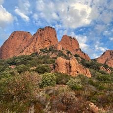
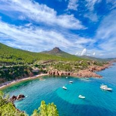
Pic de l'Ours is a 488-metre summit of reddish-brown ignimbrite porphyry in the Esterel Massif, on the territory of Saint-Raphaël in the Var. Its jagged top and broken ridge of bare rock rise above dense green vegetation, with forested hills around. A rounded neighbouring summit carries a tall white mast.
The summit formed approximately 250 million years ago during volcanic activity in the Permian period. These geological processes created the red rhyolite composition that defines the massif today.
The summit lies under a kilometre from the Col Notre-Dame, where the GR51 and GR653A long-distance paths cross, so walkers on both routes pass below it. The Dent de l'Ours, a rhyolite crag 417 m high spared by erosion, stands 450 m to the north-west, with the small Baume de l'Ours cave in its flank. The peak's name, Bear Peak, is shared by the ravine of the Baume de l'Ours that rises near the top.
The summit lies under a kilometre from the Col Notre-Dame, where the GR51 and GR653A long-distance paths cross. Mountain-bike routes exist, but some trails may be closed to bikes; the paved road climbing to the top is open to road bicycles.
The 56-metre TDF relay on the summit is not a general telecommunications tower: it carries TNT digital television to eastern Var and western Alpes-Maritimes. The mast is the slender white structure visible on the rounded top in photographs. The peak itself reaches 488 metres, and the relay stands above the red ignimbrite summit.
The community of curious travelers
AroundUs brings together thousands of curated places, local tips, and hidden gems, enriched daily by 92,791 contributors worldwide.