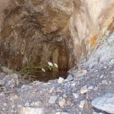
Oppidum de Verduron, Celtic-Ligurian fortified settlement in the 15th arrondissement of Marseille, France.
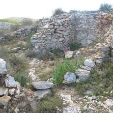
The Oppidum de Verduron is a Celtic-Ligurian fortified settlement on a rocky spur at 195 m altitude above the coast road from Marseille to L'Estaque. Its dry-stone rampart, 0.8 to 1 m thick with double facing of rough limestone bound in clay, encloses about 1,200 m2. Inside, 36 dwelling cells step down the slope in terraces, divided by a north-south wall and two streets; a 12 x 12 m square structure sits at the top.
The site was occupied from the late 3rd century BC to the early 2nd century BC, a short existence with no later rebuilding. It was destroyed violently by an army using catapults; the attackers are unidentified, possibly Greek or Roman soldiers. The destruction probably reflects Marseille's wish to retake control of its territory, of which the oppidum may have marked the edge.
The name reflects the surrounding landscape, and residents left traces of daily life through pottery and tools scattered across the grounds. These objects tell of a community closely tied to the sea and nearby hills.
The location sits on a hilltop with steep approaches, so sturdy shoes and time to explore are recommended. Note that the site today is buried beneath protective layers, though informative markers and signs explain the original layout.
The site's name comes from the local nickname "pain de sucre" (sugar loaf) for the Verduron hill. The sculptor Stanislas Clastrier bought the land in 1905 and found large stones and pottery sherds while clearing it, leading to the first excavations.
The community of curious travelers
AroundUs brings together thousands of curated places, local tips, and hidden gems, enriched daily by 93,822 contributors worldwide.