Tkibuli Reservoir, reservoir in Georgia
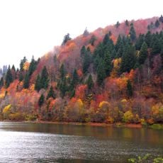
Tkibuli Reservoir lies in the Okriba basin of the Tkibuli municipality, formed by an earth-fill dam across the Tkibula River at the spot called Tsqaldasavali, where the river once vanished into a karst shaft. It is 8.1 km long, up to 3.2 km wide and 12.1 km² in area, with small bays and islands in its middle and western parts. Its shores are mostly low and gently sloping.
The reservoir was created by building an earth dam that blocks the natural flow of the Tkibula River and forms a large water basin. Though relatively young itself, it sits in a region with traces of human settlement dating to ancient times and near Tkibuli's mining heritage.
The reservoir's name comes from the Tkibula River, which once vanished into a karst shaft at the basin floor called "Tsqaldasavali" (water-sink) before the dam was built. The reservoir is rich in fish, and its water level peaks in August–September, when locals time visits to the fuller shoreline.
The reservoir lies in the Okriba basin within Tkibuli Municipality, reached from the town of Tkibuli. Water level peaks in August and September and is lowest in February and March, with an average yearly amplitude of 575 cm, so the shoreline shifts through the year. The banks are mostly low and gently sloping, and the middle and western parts hold small bays and islands.
The Tkibula River once vanished into a karst shaft at the basin floor, a spot called "Tsqaldasavali" (water-sink), before the earth-fill dam flooded it. The reservoir's level swings by an average of 575 cm a year, peaking in August–September and lowest in February–March.
The community of curious travelers
AroundUs brings together thousands of curated places, local tips, and hidden gems, enriched daily by 93,364 contributors worldwide.