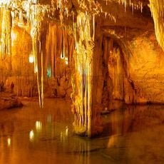
Punta Giglio, Coastal promontory in northern Sardinia, Italy.
Punta Giglio is a limestone promontory on the northern coast of Sardinia that rises approximately 80 meters (260 feet) above the Mediterranean. The formation creates a natural division between Porto Conte Bay and the Gulf of Alghero and is now managed as a nature reserve with marked trails.
A medieval watchtower once stood on the summit, part of Sardinia's coastal defence system and intervisible with other towers of the north-west. It was demolished during the Second World War to build an anti-aircraft defence system, whose barracks, gun platforms, casemates and explosives store, built of local limestone and camouflaged from the sea, still stand.
The name comes from the sea lily plants that grow here; in Algherese Catalan the promontory is La Punta del Lliri. The site is now a tourist accommodation facility under a state concession, contested by environmental groups and citizens organised as Punta Giglio Libera. The park authority's tenders for securing supposedly unstable cliff sections were also challenged.
You can reach the site via Provincial Road 55 and find marked trails for walking throughout the reserve. The paths have directional signs pointing to historic military structures and viewpoints along the way.
The three largest sea caves at the base of the promontory are Punta Giglio or dei Cervi, named for a fossil deposit of the extinct Sardinian deer Megaceros cazioti; the Grotta dei Fantasmi, with calcite concretions eroded by a forced-conduit system; and the Grotta delle Stalattiti, whose submerged stalactites and concentric calcite rings record its growth.
The community of curious travelers
AroundUs brings together thousands of curated places, local tips, and hidden gems, enriched daily by 93,394 contributors worldwide.