Enable Location

We need your location to show you interesting places around you

Discover nearby places

Find interesting locations and hidden gems around you

Precise directions

Get accurate directions and distances to places

Your location is never shared with other users. It's only used when you tap the location button.

Thanlwin Bridge

Log in to your account

Start exploring — it's free

Trusted by 62,010 travelers worldwide

Continue with Google
Continue with Apple
or

We will send you a code to connect

By continuing, you accept our Terms and Conditions and our Privacy Policy

Check your inbox

We've sent a pincode in your inbox. Please enter the code below.

Thanlwin Bridge

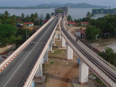
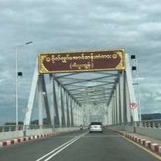
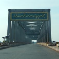
Thanlwin Bridge, Railway and road bridge in Mawlamyine, Myanmar.

Thanlwin Bridge is a combined railway and road structure that spans the Thanlwin River between Mawlamyine and Mottama. The structure has separate lanes for cars, trains, and pedestrians, with each form of transport using its own dedicated space.

Construction began in March 2000 and the structure was completed in April 2005, creating a major transportation link in southeastern Myanmar. The project marked an important step forward in the region's infrastructure development.

The bridge links communities that were previously separated by water, enabling residents to move more freely between the two sides for work and daily life. This connection has changed how people think about their region and what they can access.

The river can be strong during flood seasons and may affect access, so keeping an eye on weather conditions is wise. Visitors should also know that pedestrian access may be limited and safety precautions must be followed.

The structure stands where three rivers meet: the Thanlwin, Gyaing, and Attayan, making it strategically important. This rare geographic configuration allowed one of the region's largest bridge projects to be built.

The community of curious travelers

AroundUs brings together thousands of curated places, local tips, and hidden gems, enriched daily by 60,000 contributors worldwide.

Start exploring
Location
Inception
April 18, 2005
Official opening
April 18, 2005
Length
6,589 m
GPS coordinates
16.51110,97.61780
Latest update
December 12, 2025 09:01
Myanmar for photographers

Myanmar offers photographers an exceptional range of subjects, from ancient temple complexes to natural landscapes. The archaeological zone of Bagan, with more than 2,000 pagodas and temples spread across 40 square miles (104 square kilometers), ranks among Southeast Asia's most significant...

« Thanlwin Bridge - Railway and road bridge in Mawlamyine, Myanmar » is provided by Around Us (aroundus.com). Images and texts are derived from Wikimedia project under a Creative Commons license. You are allowed to copy, distribute, and modify copies of this page, under the conditions set by the license, as long as this note is clearly visible.

Discover hidden gems everywhere you go!

From secret cafés to breathtaking viewpoints, skip the crowded tourist spots and find places that match your style. Our app makes it easy with voice search, smart filtering, route optimization, and insider tips from travelers worldwide. Download now for the complete mobile experience.

Around Us App Screenshot

A unique approach to discovering new places

Le Figaro

All the places worth exploring

France Info

A tailor-made excursion in just a few clicks

20 Minutes

Around Us
Travel Guide & Maps
Download

Send to your phone

QR Code
1

Open the camera app on your mobile.

2

Point at the QR code with your camera. A notification will appear.

3

Tap the notification to open the link.