Chest opened
+${chestReward.xp} XP
Explorer
NOUVEAU ×${chestReward.collectible.quantity}
tapez pour fermer
Chest locked

Open chests in the app

Around Us is built for your phone — chests unlock when you walk, explore and capture nearby places.

Enable Location

We need your location to show you interesting places around you

Discover nearby places

Find interesting locations and hidden gems around you

Precise directions

Get accurate directions and distances to places

Your location is never shared with other users. It's only used when you tap the location button.

Zambales Mountains

Log in to your account

Start exploring — it's free

Trusted by 72,971 travelers worldwide

Continue with Google
Continue with Apple
or

We will send you a code to connect

By continuing, you accept our Terms and Conditions and our Privacy Policy

Check your inbox

We've sent a pincode in your inbox. Please enter the code below.

Zambales Mountains
Discussion Reviews 1 Photos
15.5k Popularity

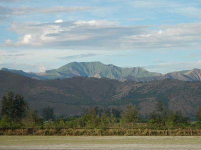
Zambales Mountains, Mountain range in western Luzon, Philippines

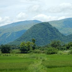
The Zambales Mountains run for roughly 180 kilometers from Lingayen Gulf to Manila Bay, crossing through five provinces. Mount Tapulao, the highest peak at around 2,000 meters, creates varied landscapes with dense forests and shifting terrain along its ridges.

The mountain range formed through geological processes that brought ancient rock layers to the surface, with origins dating back to the Jurassic and Miocene periods. Mount Pinatubo, located within the range, erupted catastrophically in 1991, making it one of the most powerful volcanic events of the twentieth century.

The Aeta people, indigenous to these mountains, live according to customs passed down through generations and participate in local conservation efforts. Visitors can encounter their communities and learn how they maintain their connection to the land.

The range has several hiking routes at different levels of difficulty, winding through forest and open ridges that take anywhere from a few hours to multiple days to complete. Visit during the drier season when trails are easier to navigate and weather conditions are more stable.

The rocks underlying the range are among the oldest geological formations in the region, later covered by layers of sediment from ancient seas that shaped the landscape in unexpected ways. This geological history is visible in exposed rock faces across the mountains, revealing how dramatically the terrain has shifted over millions of years.

The community of curious travelers

AroundUs brings together thousands of curated places, local tips, and hidden gems, enriched daily by 60,000 contributors worldwide.

Start exploring
Location
Location
Location
Location
Location
Elevation above the sea
2,037 m
GPS coordinates
15.48100,120.12100
Latest update
December 7, 2025 19:30
Reviews
Share your experience

No review yet

Discussions
Start a discussion...

No discussion yet

« Zambales Mountains - Mountain range in western Luzon, Philippines » is provided by Around Us (aroundus.com). Images and texts are derived from Wikimedia project under a Creative Commons license. You are allowed to copy, distribute, and modify copies of this page, under the conditions set by the license, as long as this note is clearly visible.

Discover hidden gems everywhere you go!

From secret cafés to breathtaking viewpoints, skip the crowded tourist spots and find places that match your style. Our app makes it easy with voice search, smart filtering, route optimization, and insider tips from travelers worldwide. Download now for the complete mobile experience.

Around Us App Screenshot

A unique approach to discovering new places

Le Figaro

All the places worth exploring

France Info

A tailor-made excursion in just a few clicks

20 Minutes

Around Us
Travel Guide & Maps
Download

Send to your phone

QR Code
1

Open the camera app on your mobile.

2

Point at the QR code with your camera. A notification will appear.

3

Tap the notification to open the link.