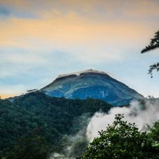
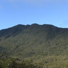
Mount Bandera, Mountain in Davao del Sur, Philippines.
Mount Bandera reaches an elevation of 551 meters above sea level and presents a vertical rise of 14 meters to its summit point.
The Geographic Names Server officially recorded Mount Bandera in its database on June 11, 2018, establishing its geographical recognition within the Philippines territory.
The mountain forms part of the natural heritage of Davao del Sur, where local communities maintain connections with the surrounding mountainous landscape.
Visitors can access detailed geographical information about Mount Bandera through the PeakVisor application, which provides 3D maps and navigation tools.
Mount Bandera ranks as the 40th highest peak among 75 mountains in Davao Occidental, with Mount Laguli standing as its nearest elevated neighbor.
Location: Davao del Sur
Address: Mount Bandera, Bayan ng Don Marcelino, Davao Occidental, Philippines Bayan ng Don Marcelino Bayan ng Don Marcelino
GPS coordinates: 6.21860,125.68670
Latest update: March 3, 2025 04:47
From Ireland's 214-meter Cliffs of Moher to China's vertical peaks in Zhangjiajie, these natural formations mark Earth's most notable vertical landscapes. The collection spans coastal features like Dover's white chalk cliffs and inland monuments such as Yosemite's El Capitan. Notable sites include Norway's Preikestolen, Hawaii's Kalaupapa cliffs reaching 1,010 meters, and Pakistan's Trango Towers, the world's highest vertical cliffs.
Mount Apo
97.1 km
Samal
92.7 km
Mount Matutum
69.4 km
San Pedro Cathedral
94.6 km
Davao River Bridge
99.3 km
Mati Protected Landscape
99.3 km
Mount Apo Natural Park
95.3 km
D' Bone Collector Museum
94.1 km
Mount Hamiguitan Range Wildlife Sanctuary
79.8 km
Museo Dabawenyo
93.7 km
Pacman Beach Resort Complex
74.3 km
Burial Site of the Seventeen Filipino Martyrs of Koronadal historical marker
98.6 km
Mount Hamiguitan
79.8 km
Mount Parker
89 km
Davao City Hall historical marker
94.6 km
Gen. Paulino Santos historical marker
58.2 km
Andres Bonifacio historical marker
91.5 km
Davao Museum of History and Ethnography
98.8 km
Ohta Kyozaburo historical marker
99.6 km
Baywalk
100.3 km
KCC Cinema
97.6 km
Koronadal Cathedral
98.5 km
Talisay Beach
77.4 km
Port Sta. Ana historical marker
95.6 km
Buhangin Memorial Park
100.4 km
Pujada Bay Protected Seascape
93.8 km
Ruins of Fort Marorong historical marker
93.8 km
Balnunto Falls
78 kmReviews
Visited this place? Tap the stars to rate it and share your experience / photos with the community! Try now! You can cancel it anytime.
Discover hidden gems everywhere you go!
From secret cafés to breathtaking viewpoints, skip the crowded tourist spots and find places that match your style. Our app makes it easy with voice search, smart filtering, route optimization, and insider tips from travelers worldwide. Download now for the complete mobile experience.
A unique approach to discovering new places❞
— Le Figaro
All the places worth exploring❞
— France Info
A tailor-made excursion in just a few clicks❞
— 20 Minutes