Chest opened
+${chestReward.xp} XP
Explorer
NOUVEAU ×${chestReward.collectible.quantity}
tapez pour fermer
Chest locked

Open chests in the app

Around Us is built for your phone — chests unlock when you walk, explore and capture nearby places.

Enable Location

We need your location to show you interesting places around you

Discover nearby places

Find interesting locations and hidden gems around you

Precise directions

Get accurate directions and distances to places

Your location is never shared with other users. It's only used when you tap the location button.

Log in to your account

Start exploring — it's free

Trusted by 72,927 travelers worldwide

Continue with Google
Continue with Apple
or

We will send you a code to connect

By continuing, you accept our Terms and Conditions and our Privacy Policy

Check your inbox

We've sent a pincode in your inbox. Please enter the code below.

Nagtahan Interchange
Discussion Reviews Photo
5.1k Popularity

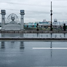
Nagtahan Interchange, Three-level interchange in Manila, Philippines

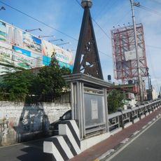
Nagtahan Interchange is a three-level road junction in Manila where three flyovers cross one another to link several major roads. It connects Lacson Avenue, Nagtahan Street, Legarda Street, Magsaysay Boulevard, and Jose P. Laurel Street into one continuous road network.

The site once held the Rotonda de Sampaloc, a roundabout from the early 1900s that marked the edge of Manila's urban center. The elevated interchange that stands today was built in 1976, replacing that earlier road structure entirely.

Students from Metro Manila universities painted murals of national heroes on the concrete columns in 2013, turning a traffic structure into an open-air gallery. The painted columns are still visible today and give the interchange a layer of meaning beyond its function as a road junction.

Access for light vehicles has been restricted since rehabilitation work began in October 2021, so checking current road conditions before driving through is a good idea. The junction handles heavy traffic from several directions, which means congestion can vary a lot depending on the time of day.

The Carriedo Fountain, which once stood at the center of the old roundabout, was moved to Plaza Santa Cruz when the interchange was built in 1976. Few people who see it there today realize it originally came from this exact spot.

The community of curious travelers

AroundUs brings together thousands of curated places, local tips, and hidden gems, enriched daily by 60,000 contributors worldwide.

Start exploring
GPS coordinates
14.60108,120.99933
Latest update
March 3, 2026 08:14
Around this place
Malacañang Palace
Philippines

Malacañang Palace

957 m
Our Lady of Montserrat Abbey
Philippines

Our Lady of Montserrat Abbey

722 m
Sampaloc Church
Philippines

Sampaloc Church

668 m
Mabini Bridge
Philippines

Mabini Bridge

625 m
Pandacan Church
Philippines

Pandacan Church

1 km
Legarda Ancestral House
Philippines

Legarda Ancestral House

791 m
Kalayaan Hall
Philippines

Kalayaan Hall

882 m
Beaterio de Terciarias Agustinas Recoletas
Philippines

Beaterio de Terciarias Agustinas Recoletas

1 km
Commission on the Filipino Language historical marker
Philippines

Commission on the Filipino Language historical marker

323 m
National University historical marker
Philippines

National University historical marker

616 m
Mendiola Street historical marker
Philippines

Mendiola Street historical marker

885 m
Florentino P. Cayco historical marker
Philippines

Florentino P. Cayco historical marker

379 m
La Consolacion College Manila historical marker
Philippines

La Consolacion College Manila historical marker

733 m
Carmen de Luna historical marker
Philippines

Carmen de Luna historical marker

785 m
Sofia Reyes de Veyra historical marker
Philippines

Sofia Reyes de Veyra historical marker

793 m
Eulogio “Amang” Rodriguez Institute of Science and Technology historical marker
Philippines

Eulogio “Amang” Rodriguez Institute of Science and Technology historical marker

260 m
Kalayaan Hall historical marker
Philippines

Kalayaan Hall historical marker

882 m
Concepcion A. Aguila historical marker
Philippines

Concepcion A. Aguila historical marker

823 m
Mabini Bridge historical marker
Philippines

Mabini Bridge historical marker

869 m
December 8, 1964 historical marker
Philippines

December 8, 1964 historical marker

453 m
The Church of Pandacan historical marker
Philippines

The Church of Pandacan historical marker

1 km
Church of Sampaloc historical marker
Philippines

Church of Sampaloc historical marker

680 m
Centro Escolar University historical marker
Philippines

Centro Escolar University historical marker

809 m
Liberation of Manila historical marker
Philippines

Liberation of Manila historical marker

947 m
Malacañang Palace historical marker
Philippines

Malacañang Palace historical marker

969 m
The University of Manila historical marker
Philippines

The University of Manila historical marker

952 m
San Beda College historical marker
Philippines

San Beda College historical marker

797 m
Abbey of Our Lady of Montserrat historical marker
Philippines

Abbey of Our Lady of Montserrat historical marker

742 m
Show the full map
Reviews
Share your experience

No review yet

Discussions
Start a discussion...

No discussion yet

« Nagtahan Interchange - Three-level interchange in Manila, Philippines » is provided by Around Us (aroundus.com). Images and texts are derived from Wikimedia project under a Creative Commons license. You are allowed to copy, distribute, and modify copies of this page, under the conditions set by the license, as long as this note is clearly visible.

Discover hidden gems everywhere you go!

From secret cafés to breathtaking viewpoints, skip the crowded tourist spots and find places that match your style. Our app makes it easy with voice search, smart filtering, route optimization, and insider tips from travelers worldwide. Download now for the complete mobile experience.

Around Us App Screenshot

A unique approach to discovering new places

Le Figaro

All the places worth exploring

France Info

A tailor-made excursion in just a few clicks

20 Minutes

Around Us
Travel Guide & Maps
Download

Send to your phone

QR Code
1

Open the camera app on your mobile.

2

Point at the QR code with your camera. A notification will appear.

3

Tap the notification to open the link.