Enable Location

We need your location to show you interesting places around you

Discover nearby places

Find interesting locations and hidden gems around you

Precise directions

Get accurate directions and distances to places

Your location is never shared with other users. It's only used when you tap the location button.

Gora Dzhutsa Pervaya

Log in to your account

Start exploring — it's free

Trusted by 63,042 travelers worldwide

Continue with Google
Continue with Apple
or

We will send you a code to connect

By continuing, you accept our Terms and Conditions and our Privacy Policy

Check your inbox

We've sent a pincode in your inbox. Please enter the code below.

Gora Dzhutsa Pervaya
Discussion Reviews 1 Photos
2.8k Popularity

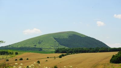
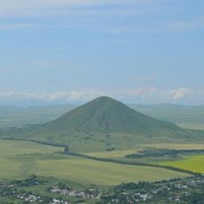
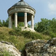
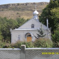
Gora Dzhutsa Pervaya, Mountain summit in Predgorny District, Stavropol Krai, Russia.

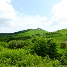
Gora Dzhutsa Pervaya is a mountain summit in Stavropol Krai that features exposed rocky ridges and mixed vegetation covering its slopes at different elevations. The terrain transitions from wooded lower sections to more open grassland as you climb higher toward the peak.

The mountain sits within the Caucasus range, a system that has served as a natural corridor for movement between different regions for centuries. Local climbing traditions have established routes through these peaks over generations.

Local mountaineering groups from Stavropol Krai regularly organize expeditions to Dzhutsa Pervaya, maintaining traditional climbing routes and documenting new paths to the summit.

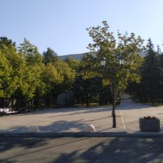
Visitors reach the summit via marked mountain trails that require basic mountaineering experience and appropriate gear for changeable weather. The walking time to the peak typically extends several hours from the nearest access point.

Among the 125 peaks in Stavropol Krai, Dzhutsa Pervaya ranks thirteenth in elevation and maintains a prominence of 290 meters above the surrounding landscape.

The community of curious travelers

AroundUs brings together thousands of curated places, local tips, and hidden gems, enriched daily by 60,000 contributors worldwide.

Start exploring
GPS coordinates
43.96925,43.02268
Latest update
December 12, 2025 14:24
Around this place
Monument to Mikhail Lermontov
Russian Federation

Monument to Mikhail Lermontov

8.8 km
Lermontov museum-reserve
Russian Federation

Lermontov museum-reserve

9 km
Храм Христа Спасителя
Russian Federation

Храм Христа Спасителя

8.7 km
Operetta Theatre of Stavropol Krai
Russian Federation

Operetta Theatre of Stavropol Krai

9 km
Central Stadium
Russian Federation

Central Stadium

7.6 km
Constantinogorsk Fortress
Russian Federation

Constantinogorsk Fortress

7.7 km
Gora Dzhutsa Vtoraya
Russian Federation

Gora Dzhutsa Vtoraya

5.8 km
Qora lola Pyatigorsk
Russian Federation

Qora lola Pyatigorsk

9.3 km
Transfiguration Church, Pyatigorsk
Russian Federation

Transfiguration Church, Pyatigorsk

8.8 km
Пятигорский краеведческий музей
Russian Federation

Пятигорский краеведческий музей

8.7 km
Mount Britaya or Dubrovka
Russian Federation

Mount Britaya or Dubrovka

4.6 km
Церковь Успения Пресвятой Богородицы (Пятигорск)
Russian Federation

Церковь Успения Пресвятой Богородицы (Пятигорск)

8.8 km
Orthodox cathedral in Pyatigorsk
Russian Federation

Orthodox cathedral in Pyatigorsk

8.8 km
Diana Grotto, Pyatigorsk
Russian Federation

Diana Grotto, Pyatigorsk

8.8 km
Pyatigorsk Red Cross Colony Ensemble
Russian Federation

Pyatigorsk Red Cross Colony Ensemble

9.2 km
Building of Pyatigorsk Alexandra and George Nurses Community
Russian Federation

Building of Pyatigorsk Alexandra and George Nurses Community

9.2 km
Gate of officers' department of infirmary
Russian Federation

Gate of officers' department of infirmary

8.9 km
Saint Olga Shelter historic hospital
Russian Federation

Saint Olga Shelter historic hospital

8.1 km
Храм Казанской Иконы Божией Матери (Юца)
Russian Federation

Храм Казанской Иконы Божией Матери (Юца)

1 km
Bath building of mud cures institution
Russian Federation

Bath building of mud cures institution

8 km
Building of lodge of Pyatigorsk Red Cross Colony
Russian Federation

Building of lodge of Pyatigorsk Red Cross Colony

9.2 km
House for poor officers
Russian Federation

House for poor officers

9 km
Building of stable of Pyatigorsk Red Cross Colony
Russian Federation

Building of stable of Pyatigorsk Red Cross Colony

9.2 km
Bolnichka
Russian Federation

Bolnichka

9.2 km
Golitsyn barrack
Russian Federation

Golitsyn barrack

9.2 km
Boiler house of Pytigorsk mud cures institution
Russian Federation

Boiler house of Pytigorsk mud cures institution

8 km
Mud cures hospital main building
Russian Federation

Mud cures hospital main building

8.1 km
Officers' department of infirmary
Russian Federation

Officers' department of infirmary

8.9 km
Show the full map
Reviews
Share your experience

No review yet

Discussions
Start a discussion...

No discussion yet

« Gora Dzhutsa Pervaya - Mountain summit in Predgorny District, Stavropol Krai, Russia » is provided by Around Us (aroundus.com). Images and texts are derived from Wikimedia project under a Creative Commons license. You are allowed to copy, distribute, and modify copies of this page, under the conditions set by the license, as long as this note is clearly visible.

Discover hidden gems everywhere you go!

From secret cafés to breathtaking viewpoints, skip the crowded tourist spots and find places that match your style. Our app makes it easy with voice search, smart filtering, route optimization, and insider tips from travelers worldwide. Download now for the complete mobile experience.

Around Us App Screenshot

A unique approach to discovering new places

Le Figaro

All the places worth exploring

France Info

A tailor-made excursion in just a few clicks

20 Minutes

Around Us
Travel Guide & Maps
Download

Send to your phone

QR Code
1

Open the camera app on your mobile.

2

Point at the QR code with your camera. A notification will appear.

3

Tap the notification to open the link.