Харнаурды-Кеу

Log in to your account

AroundUs is a community-driven map of interesting places, built by curious explorers like you. It grows with every review, story, and photo you share.
Connect to save your favorite spots, contribute locations, and create personalized routes.
Continue with Google
Continue with Apple
Continue with X
Continue with Facebook
Continue with email
By continuing, you accept our Terms and Conditions and our Privacy Policy
Create an account

Харнаурды-Кеу

Add to collection
Map
Suggest a change
Share

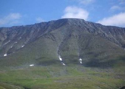
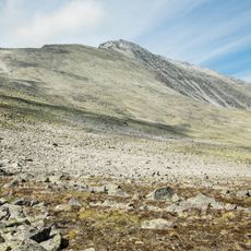
Харнаурды-Кеу, Mountain summit in Polar Urals, Russia

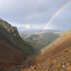
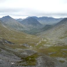
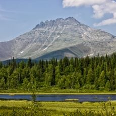
Kharnaurdy-Keu is a mountain in the Polar Urals with a plateau-shaped peak that reaches approximately 1,246 meters (4,088 feet) in elevation. The peak sits near Lake Bolshoye Khadatayoganlor in the Yamalo-Nenets region and is surrounded by valleys and river systems.

The mountain was thoroughly documented during geographical surveys in the 1960s and appeared in Russian mapping publications from 1968. This systematic recording brought the area into scientific knowledge for the first time.

The name comes from an indigenous language and refers to a story about a young reindeer that fell on the slopes. This reflects how closely local people have always connected with the mountain and the animals that share this landscape.

The best time to climb is during the short summer months when snow has melted and routes are passable. Visitors should bring sturdy equipment and have experience with alpine terrain, as conditions are rugged and weather can change quickly.

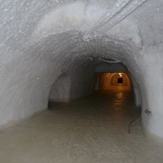
The northern slope holds a glacier that is the largest ice formation across the entire Polar Urals. This frozen mass remains visible even in warmer months and dramatically shapes the character of the northern face.

GPS coordinates: 67.57222,65.98938

Latest update: December 14, 2025 11:22

Photos
Around this place
Sabetta
Russian Federation

Sabetta

473.7 km
Mount Narodnaya
Russian Federation

Mount Narodnaya

385.5 km
Polar Ural
Russian Federation

Polar Ural

96.8 km
Obskaya–Bovanenkovo Line
Russian Federation

Obskaya–Bovanenkovo Line

329.8 km
Subpolar Ural
Russian Federation

Subpolar Ural

416.3 km
Manaraga
Russian Federation

Manaraga

395.6 km
Новопортовский мерзлотник
Russian Federation

Новопортовский мерзлотник

292.9 km
Prirazlomnaya
Russian Federation

Prirazlomnaya

400 km
Inta water tower
Russian Federation

Inta water tower

307.9 km
Dvorets Kultury Shakterov
Russian Federation

Dvorets Kultury Shakterov

83 km
Peter and Paul Church
Russian Federation

Peter and Paul Church

119.5 km
Здание инородческих управ, в котором была провозглашена советская власть в Обдорске (Салехард)
Russian Federation

Здание инородческих управ, в котором была провозглашена советская власть в Обдорске (Салехард)

119.7 km
Polar circle monument
Russian Federation

Polar circle monument

117 km
Здание театра 501-й стройки (Салехард)
Russian Federation

Здание театра 501-й стройки (Салехард)

119.6 km
Торговый дом купца И.Н. Корнилова (Салехард)
Russian Federation

Торговый дом купца И.Н. Корнилова (Салехард)

119.7 km
Obdorsky ostrog
Russian Federation

Obdorsky ostrog

119.8 km
Здание начальной школы 501-й стройки (Салехард)
Russian Federation

Здание начальной школы 501-й стройки (Салехард)

119.3 km
Obdorskoye Cemetery
Russian Federation

Obdorskoye Cemetery

118.9 km
Фрагмент застройки (2 объекта) (Салехард)
Russian Federation

Фрагмент застройки (2 объекта) (Салехард)

119.5 km
Дом купца И.А. Рочева-Моторова (Салехард)
Russian Federation

Дом купца И.А. Рочева-Моторова (Салехард)

119.5 km
Обдорское кладбище (Салехард)
Russian Federation

Обдорское кладбище (Салехард)

118.9 km
Церковь Рождества Пресвятой Богородицы (каменная) (Берёзово)
Russian Federation

Церковь Рождества Пресвятой Богородицы (каменная) (Берёзово)

407 km
Matveev Island Lighthouse
Russian Federation

Matveev Island Lighthouse

369.3 km
Церковь Николая Чудотворца — первый православный самоедский (ненецкий) храм в Большеземельской тундре (Колва)
Russian Federation

Церковь Николая Чудотворца — первый православный самоедский (ненецкий) храм в Большеземельской тундре (Колва)

418.7 km
Дом священника и церковно-приходская школа (Колва)
Russian Federation

Дом священника и церковно-приходская школа (Колва)

418.8 km
Памятник В.И. Ленину (Инта)
Russian Federation

Памятник В.И. Ленину (Инта)

308.9 km
Orthodox cathedral of the Iveron Icon of Our Lady in Vorkuta
Russian Federation

Orthodox cathedral of the Iveron Icon of Our Lady in Vorkuta

81.9 km
Church of the Nativity of the Blessed Virgin
Russian Federation

Church of the Nativity of the Blessed Virgin

407 km
Show the full map
Reviews

Visited this place? Tap the stars to rate it and share your experience / photos with the community! Try now! You can cancel it anytime.

« Харнаурды-Кеу - Mountain summit in Polar Urals, Russia » is provided by Around Us (aroundus.com). Images and texts are derived from Wikimedia project under a Creative Commons license. You are allowed to copy, distribute, and modify copies of this page, under the conditions set by the license, as long as this note is clearly visible.

Discover hidden gems everywhere you go!

From secret cafés to breathtaking viewpoints, skip the crowded tourist spots and find places that match your style. Our app makes it easy with voice search, smart filtering, route optimization, and insider tips from travelers worldwide. Download now for the complete mobile experience.

Around Us App Screenshot

A unique approach to discovering new places

Le Figaro

All the places worth exploring

France Info

A tailor-made excursion in just a few clicks

20 Minutes