Enable Location

We need your location to show you interesting places around you

Discover nearby places

Find interesting locations and hidden gems around you

Precise directions

Get accurate directions and distances to places

Your location is never shared with other users. It's only used when you tap the location button.

Scott County

Log in to your account

Start exploring — it's free

Trusted by 62,121 travelers worldwide

Continue with Google
Continue with Apple
or

We will send you a code to connect

By continuing, you accept our Terms and Conditions and our Privacy Policy

Check your inbox

We've sent a pincode in your inbox. Please enter the code below.

Scott County, Administrative division in southern Indiana, United States.

Scott County is an administrative division in southern Indiana encompassing multiple small communities across its territory. Scottsburg serves as the county seat and administrative hub where governmental services are centered.

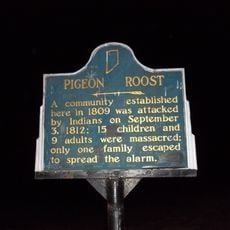
The territory was settled in the early 1800s and developed as an administrative district to support the growing population. Infrastructure was established during this period to provide essential services to residents.

Local events throughout the year bring residents together for celebrations that highlight Indiana traditions through food, music, and community gatherings.

The county administration offers online services for property taxes, bill payments, and access to important documents through its official website. These digital resources make it easy to handle administrative matters from home.

The geographical location at latitude 38.67 and longitude -85.74 places Scott County at a central position for regional administrative coordination.

The community of curious travelers

AroundUs brings together thousands of curated places, local tips, and hidden gems, enriched daily by 60,000 contributors worldwide.

Start exploring
GPS coordinates
38.67270,-85.74441
Latest update
December 7, 2025 19:28
Around this place
Clifty Falls State Park
United States of America

Clifty Falls State Park

29.8 km
Rose Island
United States of America

Rose Island

29.2 km
Freeman Field Mutiny
United States of America

Freeman Field Mutiny

31.5 km
Pigeon Roost State Historic Site
United States of America

Pigeon Roost State Historic Site

6.7 km
Charlestown State Park
United States of America

Charlestown State Park

28.8 km
Lanier Mansion
United States of America

Lanier Mansion

31.8 km
Muscatatuck National Wildlife Refuge
United States of America

Muscatatuck National Wildlife Refuge

29.5 km
Deam Lake State Recreation Area
United States of America

Deam Lake State Recreation Area

24.8 km
Milton-Madison Bridge
United States of America

Milton-Madison Bridge

33.1 km
United States of America

New Albany Shale

4.9 km
Madison Historic District
United States of America

Madison Historic District

32.8 km
Eleutherian College
United States of America

Eleutherian College

26.5 km
John Work House and Mill Site
United States of America

John Work House and Mill Site

23.4 km
Charles L. Shrewsbury House
United States of America

Charles L. Shrewsbury House

32.2 km
United States of America

Stream Cliff Farm

23.6 km
Schofield House
United States of America

Schofield House

32.2 km
Lyman and Asenath Hoyt House
United States of America

Lyman and Asenath Hoyt House

26.3 km
Scott County Home
United States of America

Scott County Home

2.3 km
Thomas Downs House
United States of America

Thomas Downs House

26.5 km
Scottsburg Courthouse Square Historic District
United States of America

Scottsburg Courthouse Square Historic District

2.6 km
Rising Sun Historic District
United States of America

Rising Sun Historic District

32.1 km
Benjamin Ferguson House
United States of America

Benjamin Ferguson House

26.8 km
Watson House
United States of America

Watson House

26.3 km
Crawford-Whitehead-Ross House
United States of America

Crawford-Whitehead-Ross House

32 km
Crowe-Garritt House
United States of America

Crowe-Garritt House

24.3 km
Wooded Glen Covered Bridge
United States of America

Wooded Glen Covered Bridge

10.9 km
Hayden Historical Museum
United States of America

Hayden Historical Museum

34.4 km
James Covered Bridge
United States of America

James Covered Bridge

26.9 km
Show the full map
« Scott County - Administrative division in southern Indiana, United States » is provided by Around Us (aroundus.com). Images and texts are derived from Wikimedia project under a Creative Commons license. You are allowed to copy, distribute, and modify copies of this page, under the conditions set by the license, as long as this note is clearly visible.

Discover hidden gems everywhere you go!

From secret cafés to breathtaking viewpoints, skip the crowded tourist spots and find places that match your style. Our app makes it easy with voice search, smart filtering, route optimization, and insider tips from travelers worldwide. Download now for the complete mobile experience.

Around Us App Screenshot

A unique approach to discovering new places

Le Figaro

All the places worth exploring

France Info

A tailor-made excursion in just a few clicks

20 Minutes

Around Us
Travel Guide & Maps
Download

Send to your phone

QR Code
1

Open the camera app on your mobile.

2

Point at the QR code with your camera. A notification will appear.

3

Tap the notification to open the link.