·

Enable Location

We need your location to show you interesting places around you

Discover nearby places

Find interesting locations and hidden gems around you

Precise directions

Get accurate directions and distances to places

Your location is never shared with other users. It's only used when you tap the location button.

Prophetstown State Park

Log in to your account

Start exploring — it's free

Trusted by 62,689 travelers worldwide

Continue with Google
Continue with Apple
or

We will send you a code to connect

By continuing, you accept our Terms and Conditions and our Privacy Policy

Check your inbox

We've sent a pincode in your inbox. Please enter the code below.

Prophetstown State Park

Prophetstown State Park, State park and nature preserve in West Lafayette, Indiana

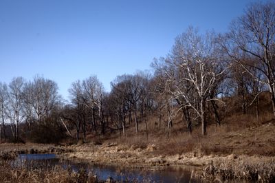
Prophetstown State Park is a protected area in Indiana that encompasses restored prairies, wetlands, and the meeting point of two rivers. The grounds extend along the edge of West Lafayette, where walking routes pass through tall-stem grassland and marshy zones.

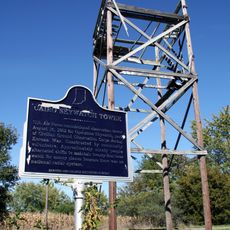
In the early nineteenth century, Tecumseh and his brother established a village here that became a center of resistance to European expansion. After the military confrontation in 1811, inhabitants left the land, which was later taken over by settlers.

The name refers to Tenskwatawa, the Shawnee Prophet, who founded a settlement here with his brother Tecumseh. Visitor centers now display farming equipment from the twenties and explain how native peoples grew corn and squash.

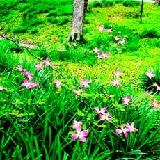
Overnight options exist at several campgrounds, some with electrical connections for trailers and tents. Walks through grassland areas work best in spring and autumn, when wildflowers are visible and temperatures remain comfortable.

Raised viewing points along a longer trail allow views of hillside springs called perched fens, which support rare plant species. These water outflows occur due to geological layers that hold rainwater near the surface.

The community of curious travelers

AroundUs brings together thousands of curated places, local tips, and hidden gems, enriched daily by 60,000 contributors worldwide.

Start exploring
Location
Inception
2004
Operator
Indiana Department of Nature Resources
GPS coordinates
40.50000,-86.83330
Latest update
December 20, 2025 15:10
Around this place
Samara
United States of America

Samara

9.8 km
Tippecanoe Battlefield Park
United States of America

Tippecanoe Battlefield Park

1.2 km
Cathedral of Saint Mary of the Immaculate Conception
United States of America

Cathedral of Saint Mary of the Immaculate Conception

10.1 km
Jerry E. Clegg Botanic Garden
United States of America

Jerry E. Clegg Botanic Garden

10 km
Cairo Skywatch Tower
United States of America

Cairo Skywatch Tower

9 km
Centennial Neighborhood District
United States of America

Centennial Neighborhood District

9.9 km
Upper Main Street Historic District
United States of America

Upper Main Street Historic District

10.1 km
Happy Hollow Heights Historic District
United States of America

Happy Hollow Heights Historic District

8.5 km
Hills and Dales Historic District
United States of America

Hills and Dales Historic District

9.9 km
Trinity United Methodist Church
United States of America

Trinity United Methodist Church

10.1 km
Jefferson Historic District
United States of America

Jefferson Historic District

9.7 km
St. John's Episcopal Church
United States of America

St. John's Episcopal Church

10.1 km
Hershey House
United States of America

Hershey House

8.3 km
Perrin Historic District
United States of America

Perrin Historic District

9.7 km
St. Mary Historic District
United States of America

St. Mary Historic District

10.1 km
Indiana State Soldiers Home Historic District
United States of America

Indiana State Soldiers Home Historic District

5.7 km
James Pierce Jr. House
United States of America

James Pierce Jr. House

8.5 km
Battle Ground Historic District
United States of America

Battle Ground Historic District

1.2 km
James H. Ward House
United States of America

James H. Ward House

10.1 km
Marian Apartments
United States of America

Marian Apartments

10 km
Ely Homestead
United States of America

Ely Homestead

5.8 km
Curtis-Grace House
United States of America

Curtis-Grace House

8.6 km
Park Mary Historic District
United States of America

Park Mary Historic District

9.3 km
Waldron-Beck House and Carriage House
United States of America

Waldron-Beck House and Carriage House

8.9 km
Chauncey-Stadium Avenues Historic District
United States of America

Chauncey-Stadium Avenues Historic District

9.8 km
Scott Street Pavilion
United States of America

Scott Street Pavilion

10 km
Prophetstown Aquatic Center
United States of America

Prophetstown Aquatic Center

846 m
Museums At Prophetstown
United States of America

Museums At Prophetstown

654 m
Show the full map
« Prophetstown State Park - State park and nature preserve in West Lafayette, Indiana » is provided by Around Us (aroundus.com). Images and texts are derived from Wikimedia project under a Creative Commons license. You are allowed to copy, distribute, and modify copies of this page, under the conditions set by the license, as long as this note is clearly visible.

Discover hidden gems everywhere you go!

From secret cafés to breathtaking viewpoints, skip the crowded tourist spots and find places that match your style. Our app makes it easy with voice search, smart filtering, route optimization, and insider tips from travelers worldwide. Download now for the complete mobile experience.

Around Us App Screenshot

A unique approach to discovering new places

Le Figaro

All the places worth exploring

France Info

A tailor-made excursion in just a few clicks

20 Minutes

Around Us
Travel Guide & Maps
Download

Send to your phone

QR Code
1

Open the camera app on your mobile.

2

Point at the QR code with your camera. A notification will appear.

3

Tap the notification to open the link.