·

Enable Location

We need your location to show you interesting places around you

Discover nearby places

Find interesting locations and hidden gems around you

Precise directions

Get accurate directions and distances to places

Your location is never shared with other users. It's only used when you tap the location button.

Happy Hollow Heights Historic District

Log in to your account

Start exploring — it's free

Trusted by 62,723 travelers worldwide

Continue with Google
Continue with Apple
or

We will send you a code to connect

By continuing, you accept our Terms and Conditions and our Privacy Policy

Check your inbox

We've sent a pincode in your inbox. Please enter the code below.

Happy Hollow Heights Historic District, Residential historic district in West Lafayette, United States.

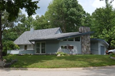
Happy Hollow Heights Historic District is a residential neighborhood in West Lafayette containing 54 homes spread across about 64 acres. The properties line Happy Hollow Road and nearby streets such as Laurel Drive, Hollowood Drive, Fearnleaf Drive, and Sumac Drive.

The neighborhood started developing in 1953 when the land was first divided into building lots, and expansion continued in 1958 with more construction. This period marked the broader transformation of the West Lafayette area as it grew outward.

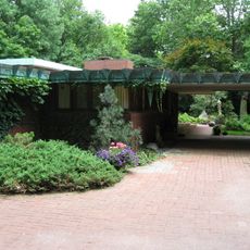
The homes here reflect the building preferences of post-World War II families who shaped this neighborhood. Walking through the streets, you notice how the variety of house styles tells the story of how residential design evolved during that era.

This is a walkable residential area with tree-lined streets and spacious lots that are easy to explore on foot. Parking your car near the main roads and walking through the neighborhood is the best way to see the different houses and their architectural styles.

The district was added to the National Register of Historic Places in 2015 for its representation of post-World War II suburban growth patterns. This recognition highlights its value as a place to understand how American suburbs took shape during that era.

The community of curious travelers

AroundUs brings together thousands of curated places, local tips, and hidden gems, enriched daily by 60,000 contributors worldwide.

Start exploring
Location
GPS coordinates
40.44333,-86.90028
Latest update
December 14, 2025 18:02
Around this place
Ross–Ade Stadium
United States of America

Ross–Ade Stadium

1.8 km
Samara
United States of America

Samara

1.5 km
Elliott Hall of Music
United States of America

Elliott Hall of Music

2.1 km
Purdue Memorial Union
United States of America

Purdue Memorial Union

2.3 km
Engineering Fountain
United States of America

Engineering Fountain

2 km
Tippecanoe County Courthouse
United States of America

Tippecanoe County Courthouse

2.8 km
Slayter Center of Performing Arts
United States of America

Slayter Center of Performing Arts

2.3 km
Purdue University Horticulture Gardens
United States of America

Purdue University Horticulture Gardens

2.5 km
Downtown Lafayette Historic District
United States of America

Downtown Lafayette Historic District

2.8 km
Former Alpha Tau Omega Fraternity House
United States of America

Former Alpha Tau Omega Fraternity House

2.3 km
Centennial Neighborhood District
United States of America

Centennial Neighborhood District

2.5 km
LaFayette Fountain
United States of America

LaFayette Fountain

2.8 km
Long Center for the Performing Arts
United States of America

Long Center for the Performing Arts

2.9 km
Upper Main Street Historic District
United States of America

Upper Main Street Historic District

2.9 km
Jesse Andrew House
United States of America

Jesse Andrew House

2.2 km
The Varsity
United States of America

The Varsity

2.3 km
Morton School
United States of America

Morton School

2.1 km
Hills and Dales Historic District
United States of America

Hills and Dales Historic District

1.4 km
Trinity United Methodist Church
United States of America

Trinity United Methodist Church

2.6 km
Jefferson Historic District
United States of America

Jefferson Historic District

2.7 km
St. John's Episcopal Church
United States of America

St. John's Episcopal Church

2.7 km
Indiana State Soldiers Home Historic District
United States of America

Indiana State Soldiers Home Historic District

3 km
Marian Apartments
United States of America

Marian Apartments

2.7 km
Curtis-Grace House
United States of America

Curtis-Grace House

749 m
Park Mary Historic District
United States of America

Park Mary Historic District

2.4 km
Waldron-Beck House and Carriage House
United States of America

Waldron-Beck House and Carriage House

3.1 km
Chauncey-Stadium Avenues Historic District
United States of America

Chauncey-Stadium Avenues Historic District

1.4 km
Harwood Tree Improvement and Regeneration Center
United States of America

Harwood Tree Improvement and Regeneration Center

2.5 km
Show the full map
« Happy Hollow Heights Historic District - Residential historic district in West Lafayette, United States » is provided by Around Us (aroundus.com). Images and texts are derived from Wikimedia project under a Creative Commons license. You are allowed to copy, distribute, and modify copies of this page, under the conditions set by the license, as long as this note is clearly visible.

Discover hidden gems everywhere you go!

From secret cafés to breathtaking viewpoints, skip the crowded tourist spots and find places that match your style. Our app makes it easy with voice search, smart filtering, route optimization, and insider tips from travelers worldwide. Download now for the complete mobile experience.

Around Us App Screenshot

A unique approach to discovering new places

Le Figaro

All the places worth exploring

France Info

A tailor-made excursion in just a few clicks

20 Minutes

Around Us
Travel Guide & Maps
Download

Send to your phone

QR Code
1

Open the camera app on your mobile.

2

Point at the QR code with your camera. A notification will appear.

3

Tap the notification to open the link.