Van Wert County

Log in to your account

AroundUs is a community-driven map of interesting places, built by curious explorers like you. It grows with every review, story, and photo you share.
Connect to save your favorite spots, contribute locations, and create personalized routes.
Continue with Google
Continue with Apple
Continue with X
Continue with Facebook
Continue with email
By continuing, you accept our Terms and Conditions and our Privacy Policy
Create an account
Add to collection
Map
Suggest a change
Share

Van Wert County, Administrative county in northwestern Ohio, United States.

Van Wert County is an administrative county in northwestern Ohio with gently rolling farmland and agricultural character throughout. The region contains several small towns and communities, with the city of Van Wert serving as the largest settlement and county seat.

This county was established in 1820 and named after Isaac Van Wart, an American patriot from the Revolutionary era. Its creation reflected the westward expansion of the young United States during the early 19th century.

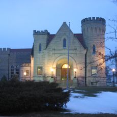
The Brumback Library in the county seat of Van Wert was founded in 1901 and became the first public library system organized at the county level in the nation. Visitors can explore its historical collections and local archives that document the region's story.

The city of Van Wert serves as the administrative center where most county offices and public services are located. A car is helpful for exploring the area, as communities are spread out and public transportation options are limited.

The county borders a different Allen County to the east in Ohio and another Allen County to the west in Indiana. This creates an unusual geographic arrangement where the same county name appears on both sides of its boundaries.

Location: Ohio

Inception: February 12, 1820

Capital city: Van Wert

Shares border with: Allen County, Mercer County, Paulding County, Putnam County, Auglaize County, Adams County, Allen County

Website: http://vanwertcounty.org

GPS coordinates: 40.86000,-84.59000

Latest update: December 7, 2025 20:22

Photos
Around this place
Grand Lake St. Marys State Park
United States of America

Grand Lake St. Marys State Park

37.4 km
Brumback Library
United States of America

Brumback Library

1.1 km
St. John's Catholic Church
United States of America

St. John's Catholic Church

21.5 km
Grand Lake St. Marys Lighthouse
United States of America

Grand Lake St. Marys Lighthouse

36.4 km
Miami and Erie Canal Deep Cut
United States of America

Miami and Erie Canal Deep Cut

27 km
Marsh Foundation School
United States of America

Marsh Foundation School

2.5 km
Van Wert County Courthouse
United States of America

Van Wert County Courthouse

1.3 km
Lenhart Farmhouse
United States of America

Lenhart Farmhouse

27.8 km
Holy Trinity Catholic Church
United States of America

Holy Trinity Catholic Church

41.3 km
St. Louis, Besancon, Historic District
United States of America

St. Louis, Besancon, Historic District

36.2 km
Paulding County Courthouse
United States of America

Paulding County Courthouse

30.9 km
Ceylon Covered Bridge
United States of America

Ceylon Covered Bridge

40.4 km
Griffith Breese Farm
United States of America

Griffith Breese Farm

40.3 km
Paulding County Carnegie Library
United States of America

Paulding County Carnegie Library

30.7 km
Peace Monument
United States of America

Peace Monument

28.4 km
Van Wert Bandstand
United States of America

Van Wert Bandstand

1.9 km
Adams County Courthouse
United States of America

Adams County Courthouse

28.4 km
Round Barn
United States of America

Round Barn

35 km
Marks-Family House
United States of America

Marks-Family House

21.4 km
Dr. Issac Elmer Williams House and Office
United States of America

Dr. Issac Elmer Williams House and Office

38.8 km
Bredeick-Lang House
United States of America

Bredeick-Lang House

20.7 km
Round Barn
United States of America

Round Barn

34.8 km
Charles Dugan House
United States of America

Charles Dugan House

28.6 km
Grand Lake St. Marys
United States of America

Grand Lake St. Marys

37.7 km
Round Barn
United States of America

Round Barn

14.6 km
United States of America

Round Barn

34.8 km
Ben Colter Polygonal Barn
United States of America

Ben Colter Polygonal Barn

22.2 km
John S. Bowers House
United States of America

John S. Bowers House

28.3 km
Show the full map
Reviews

Visited this place? Tap the stars to rate it and share your experience / photos with the community! Try now! You can cancel it anytime.

Administrative divisions
« Van Wert County - Administrative county in northwestern Ohio, United States » is provided by Around Us (aroundus.com). Images and texts are derived from Wikimedia project under a Creative Commons license. You are allowed to copy, distribute, and modify copies of this page, under the conditions set by the license, as long as this note is clearly visible.

Discover hidden gems everywhere you go!

From secret cafés to breathtaking viewpoints, skip the crowded tourist spots and find places that match your style. Our app makes it easy with voice search, smart filtering, route optimization, and insider tips from travelers worldwide. Download now for the complete mobile experience.

Around Us App Screenshot

A unique approach to discovering new places

Le Figaro

All the places worth exploring

France Info

A tailor-made excursion in just a few clicks

20 Minutes