Paulding County Courthouse

Log in to your account

AroundUs is a community-driven map of interesting places, built by curious explorers like you. It grows with every review, story, and photo you share.
Connect to save your favorite spots, contribute locations, and create personalized routes.
Continue with Google
Continue with Apple
Continue with X
Continue with Facebook
Continue with email
By continuing, you accept our Terms and Conditions and our Privacy Policy
Create an account
Add to collection
Map
Suggest a change
Share

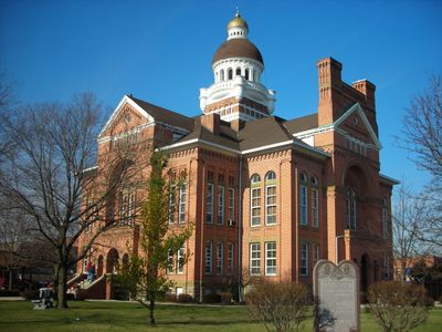
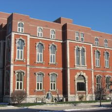
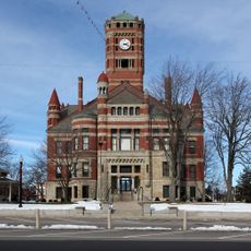
Paulding County Courthouse, County courthouse in Paulding, Ohio, US

Paulding County Courthouse is a substantial red brick courthouse built in the Richardsonian Romanesque style with a stone foundation that gives it a solid appearance. A central tower rises roughly 163 feet above the building and is balanced by four identical entrances positioned around the structure.

This courthouse was built in 1888 as a replacement for two earlier county buildings that had served the same purpose. It was added to the National Register of Historic Places in 1974, marking its recognition as an important example of 19th century architectural tradition.

The courthouse serves as a civic hub where residents conduct official business and participate in community ceremonies that mark important life moments. Its commanding presence in town has made it a gathering place that locals recognize as a symbol of order and continuity in their community.

Plan your visit during working hours when public services are available and building access is assured. The four entrances positioned around the building make it easy to approach from any direction, which is helpful for those with mobility considerations.

This building shares its architectural design with Lenawee County Courthouse in Michigan because both were created by architect E.O. Fallis. The parallel designs show how architects of this era developed signature styles that they refined across multiple projects.

Location: Ohio

Inception: 1888

Architects: E.O. Fallis

Architectural style: Richardsonian Romanesque

GPS coordinates: 41.13750,-84.58030

Latest update: December 14, 2025 18:45

Photos
Around this place
Nickel Plate Road 765
United States of America

Nickel Plate Road 765

30.4 km
Fort Defiance
United States of America

Fort Defiance

25.1 km
Independence Dam State Park
United States of America

Independence Dam State Park

30.4 km
United States of America

Fort Wayne Moraine

38.4 km
Brumback Library
United States of America

Brumback Library

29.9 km
St. John's Catholic Church
United States of America

St. John's Catholic Church

38.7 km
Marsh Foundation School
United States of America

Marsh Foundation School

29.5 km
Spencerville Covered Bridge
United States of America

Spencerville Covered Bridge

32.2 km
Van Wert County Courthouse
United States of America

Van Wert County Courthouse

29.8 km
Lenhart Farmhouse
United States of America

Lenhart Farmhouse

43.2 km
Fort Wayne Park and Boulevard System Historic District
United States of America

Fort Wayne Park and Boulevard System Historic District

43.6 km
St. Louis, Besancon, Historic District
United States of America

St. Louis, Besancon, Historic District

31.6 km
Defiance County Courthouse
United States of America

Defiance County Courthouse

24.7 km
Paulding County Carnegie Library
United States of America

Paulding County Carnegie Library

181 m
Van Wert Bandstand
United States of America

Van Wert Bandstand

29.1 km
Defiance Public Library
United States of America

Defiance Public Library

25 km
Marks-Family House
United States of America

Marks-Family House

38.5 km
Williams County Courthouse
United States of America

Williams County Courthouse

37.5 km
Dey Road Bridge
United States of America

Dey Road Bridge

23.6 km
Bredeick-Lang House
United States of America

Bredeick-Lang House

38.2 km
St. Paul's Episcopal Church
United States of America

St. Paul's Episcopal Church

23 km
Round Barn
United States of America

Round Barn

5.7 km
Brooke Site
United States of America

Brooke Site

19.1 km
Downtown Butler Historic District
United States of America

Downtown Butler Historic District

40.6 km
Round Barn
United States of America

Round Barn

35.3 km
United States of America

Round Barn

38.6 km
Riverside Chapel
United States of America

Riverside Chapel

22.7 km
Spemica Lawba-Johnny Logan
United States of America

Spemica Lawba-Johnny Logan

25.1 km
Show the full map
Reviews

Visited this place? Tap the stars to rate it and share your experience / photos with the community! Try now! You can cancel it anytime.

« Paulding County Courthouse - County courthouse in Paulding, Ohio, US » is provided by Around Us (aroundus.com). Images and texts are derived from Wikimedia project under a Creative Commons license. You are allowed to copy, distribute, and modify copies of this page, under the conditions set by the license, as long as this note is clearly visible.

Discover hidden gems everywhere you go!

From secret cafés to breathtaking viewpoints, skip the crowded tourist spots and find places that match your style. Our app makes it easy with voice search, smart filtering, route optimization, and insider tips from travelers worldwide. Download now for the complete mobile experience.

Around Us App Screenshot

A unique approach to discovering new places

Le Figaro

All the places worth exploring

France Info

A tailor-made excursion in just a few clicks

20 Minutes