Coffre ${chestReward.rarityLabel}
+${chestReward.xp} XP
Explorer
NOUVEAU ×${chestReward.collectible.quantity}
tapez pour fermer
Coffre
Épique Rare Commun
XP
+${(chestInfoModal.chest && chestInfoModal.chest.xp) || 0}
Expire
expiré ${chestInfoExpiresMinutes()} min ${Math.floor(chestInfoExpiresMinutes() / 60)} h ${chestInfoExpiresMinutes() % 60} min

Tu es dans la zone de fouille. Une fois ouvert, le contenu n'est révélé qu'après le tirage.

🔑
Cet item nécessite une clé Illustrator Ambassador Guide . Tu n'en as pas pour l'instant. Tu en as ${chestInfoMatchingKeyCount()} — réessaie pour la consommer.

Tu peux mettre ce coffre en attente : il restera dans ta file (${(collectibles_meta.savedChests || []).length} / ${collectibles_meta.savedChestsMax || 10}) jusqu'à ce que tu décroches la clé manquante.

Coffre

Trouve la paire

Gratte 3 cases. Deux symboles identiques = coffre ouvert.

⚠ Pas de paire en 3 grattages → contenu perdu.

Grattages
${(chestScratchModal.max - chestScratchModal.used)} / ${chestScratchModal.max}

Glisse pour gratter — révèle ~ la moitié et la case s'ouvre.

Coffre ·

Enable Location

We need your location to show you interesting places around you

Discover nearby places

Find interesting locations and hidden gems around you

Precise directions

Get accurate directions and distances to places

Your location is never shared with other users. It's only used when you tap the location button.

Lexington Park

Log in to your account

Start exploring — it's free

Trusted by 71,912 travelers worldwide

Continue with Google
Continue with Apple
or

We will send you a code to connect

By continuing, you accept our Terms and Conditions and our Privacy Policy

Check your inbox

We've sent a pincode in your inbox. Please enter the code below.

Discussion Reviews 1 Photos
23.4k Popularity

Lexington Park, census-designated place in St. Mary's County, Maryland, United States

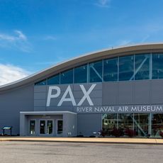
Lexington Park is an unincorporated community in St. Mary's County, Maryland, centered around a major military installation. The area functions as a residential and commercial hub with typical suburban amenities and services for its residents.

The community grew during the mid-20th century as a residential area tied to the nearby military base's expansion. This connection shaped the area's development and character from its earliest days.

The area is best explored by car and offers adequate parking throughout residential and commercial sections. Early mornings and afternoons tend to be less crowded times to visit shops and dining locations.

The community of curious travelers

AroundUs brings together thousands of curated places, local tips, and hidden gems, enriched daily by 60,000 contributors worldwide.

Start exploring
Inception
1943
Elevation above the sea
35 m
GPS coordinates
38.26667,-76.45389
Latest update
December 20, 2025 14:22
Around this place
Governor Thomas Johnson Bridge
United States of America

Governor Thomas Johnson Bridge

6.8 km
Patuxent River Naval Air Museum
United States of America

Patuxent River Naval Air Museum

1.4 km
Calvert Marine Museum
United States of America

Calvert Marine Museum

7.2 km
Drum Point Light
United States of America

Drum Point Light

7.2 km
Porto Bello
United States of America

Porto Bello

10.3 km
Our Lady Star of the Sea Catholic Church
United States of America

Our Lady Star of the Sea Catholic Church

6.6 km
William B. Tennison
United States of America

William B. Tennison

6.5 km
Cedar Point Light
United States of America

Cedar Point Light

8.4 km
United States Colored Troops Memorial Monument
United States of America

United States Colored Troops Memorial Monument

759 m
West St. Mary's Manor
United States of America

West St. Mary's Manor

9 km
J. C. Lore Oyster House
United States of America

J. C. Lore Oyster House

6.4 km
United States of America

Mattapany

3.1 km
United States of America

St. Richard's Manor

3.5 km
Cecil's Mill Historic District
United States of America

Cecil's Mill Historic District

5.2 km
James P. Muldoon River Center
United States of America

James P. Muldoon River Center

8.8 km
Historic St. Mary's City
United States of America

Historic St. Mary's City

9.8 km
United States of America

Yellows Banks

7.8 km
United States of America

Pond Number Three

2.4 km
United States of America

Cecils Mill Historic District

5.2 km
United States of America

Solomons Gallery

6 km
United States of America

St. Mary's River State Park

4.1 km
United States of America

"On Watch"

6.6 km
United States of America

Church Point

8.9 km
United States of America

Monument featuring aircraft

3.7 km
United States of America

Monument featuring aircraft

3.7 km
United States of America

Monument featuring aircraft

3.7 km
United States of America

Monument featuring aircraft

2.5 km
United States of America

1634 Cannon

9.4 km
Show the full map
Reviews
Share your experience

No review yet

Discussions
Start a discussion...

No discussion yet

« Lexington Park - census-designated place in St. Mary's County, Maryland, United States » is provided by Around Us (aroundus.com). Images and texts are derived from Wikimedia project under a Creative Commons license. You are allowed to copy, distribute, and modify copies of this page, under the conditions set by the license, as long as this note is clearly visible.

Discover hidden gems everywhere you go!

From secret cafés to breathtaking viewpoints, skip the crowded tourist spots and find places that match your style. Our app makes it easy with voice search, smart filtering, route optimization, and insider tips from travelers worldwide. Download now for the complete mobile experience.

Around Us App Screenshot

A unique approach to discovering new places

Le Figaro

All the places worth exploring

France Info

A tailor-made excursion in just a few clicks

20 Minutes

Around Us
Travel Guide & Maps
Download

Send to your phone

QR Code
1

Open the camera app on your mobile.

2

Point at the QR code with your camera. A notification will appear.

3

Tap the notification to open the link.