Chest opened
+${chestReward.xp} XP
Explorer
NOUVEAU ×${chestReward.collectible.quantity}
tapez pour fermer
Chest locked

Open chests in the app

Around Us is built for your phone — chests unlock when you walk, explore and capture nearby places.

Enable Location

We need your location to show you interesting places around you

Discover nearby places

Find interesting locations and hidden gems around you

Precise directions

Get accurate directions and distances to places

Your location is never shared with other users. It's only used when you tap the location button.

Log in to your account

Start exploring — it's free

Trusted by 72,926 travelers worldwide

Continue with Google
Continue with Apple
or

We will send you a code to connect

By continuing, you accept our Terms and Conditions and our Privacy Policy

Check your inbox

We've sent a pincode in your inbox. Please enter the code below.

Ash Hollow Formation
Discussion Reviews Photo
1.3k Popularity

Ash Hollow Formation, Geological formation in Nebraska and South Dakota, United States.

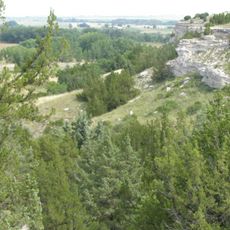
The Ash Hollow Formation is a geological sequence extending across Nebraska and South Dakota composed of sand, sandstone, and limestone layers. These strata reach depths of around 600 feet (180 meters) and contain abundant fossilized plant remains from the Neogene period.

The formation was first scientifically documented in 1876 when a geologist identified distinct rock strata near the confluence of the North and South Platte Rivers. This early recognition established the foundation for decades of geological research in the region.

Paleontologists regularly study fossil collections of extinct mammals, birds, and reptiles preserved in the layers here. These discoveries help scientists understand what animals once inhabited this region.

The formation can be studied at several locations, particularly at Ash Hollow State Historical Park and the Pratt Quarry in Brown County. Visitors should bring appropriate gear since some exposures lie in uneven terrain and allow direct access to the rock faces.

The layers contain volcanic ash beds from the Tertiary period that provide rare insights into volcanic activity across the Great Plains millions of years ago. These ash layers help scientists understand how ancient eruptions shaped the environment of that time.

The community of curious travelers

AroundUs brings together thousands of curated places, local tips, and hidden gems, enriched daily by 60,000 contributors worldwide.

Start exploring
Location
Location
Part of
Ogallala Group
GPS coordinates
41.29806,-102.12000
Latest update
March 22, 2026 02:16
Around this place
Lake McConaughy
United States of America

Lake McConaughy

34.7 km
Ash Hollow State Historical Park
United States of America

Ash Hollow State Historical Park

0 m
Wallace W. Waterman Sod House
United States of America

Wallace W. Waterman Sod House

12.7 km
Sedgwick County Courthouse
United States of America

Sedgwick County Courthouse

36.5 km
Phelps Hotel
United States of America

Phelps Hotel

26.4 km
Lewellen State Aid Bridge
United States of America

Lewellen State Aid Bridge

2.9 km
Deuel County Courthouse
United States of America

Deuel County Courthouse

37.2 km
Leonidas A. Brandhoefer Mansion
United States of America

Leonidas A. Brandhoefer Mansion

38.1 km
Fred and Minnie Meyer Sudman House
United States of America

Fred and Minnie Meyer Sudman House

37.1 km
Garden County Courthouse
United States of America

Garden County Courthouse

22.4 km
Oshkosh Water Tower
United States of America

Oshkosh Water Tower

22.3 km
Menter Farmstead
United States of America

Menter Farmstead

24 km
Dr. Burdette and Myrna Gainsforth House
United States of America

Dr. Burdette and Myrna Gainsforth House

38.1 km
Diamond Springs Stage Station Site
United States of America

Diamond Springs Stage Station Site

30.2 km
Hippodrome Theatre
United States of America

Hippodrome Theatre

36.6 km
United States of America

Signal Bluff

10.1 km
United States of America

Eagle Point

31.9 km
United States of America

Eagles Cliff

21.7 km
United States of America

Coumbe Bluff

33 km
United States of America

Sedgwick County Golf Association

34 km
United States of America

Chappell Golf Course

37.5 km
United States of America

Great Platte River Road Historical Marker

30.3 km
United States of America

Julesburg and Fort Sedgwick Historical Marker

30.3 km
United States of America

Big Springs Historical Marker

30.3 km
United States of America

Mansion on the Hill

38.1 km
United States of America

Cedar View Beach

15.9 km

Ogallala Beach

34.5 km
United States of America

Scenic viewpoint

30.3 km
Show the full map
Reviews
Share your experience

No review yet

Discussions
Start a discussion...

No discussion yet

« Ash Hollow Formation - Geological formation in Nebraska and South Dakota, United States » is provided by Around Us (aroundus.com). Images and texts are derived from Wikimedia project under a Creative Commons license. You are allowed to copy, distribute, and modify copies of this page, under the conditions set by the license, as long as this note is clearly visible.

Discover hidden gems everywhere you go!

From secret cafés to breathtaking viewpoints, skip the crowded tourist spots and find places that match your style. Our app makes it easy with voice search, smart filtering, route optimization, and insider tips from travelers worldwide. Download now for the complete mobile experience.

Around Us App Screenshot

A unique approach to discovering new places

Le Figaro

All the places worth exploring

France Info

A tailor-made excursion in just a few clicks

20 Minutes

Around Us
Travel Guide & Maps
Download

Send to your phone

QR Code
1

Open the camera app on your mobile.

2

Point at the QR code with your camera. A notification will appear.

3

Tap the notification to open the link.