Enable Location

We need your location to show you interesting places around you

Discover nearby places

Find interesting locations and hidden gems around you

Precise directions

Get accurate directions and distances to places

Your location is never shared with other users. It's only used when you tap the location button.

Napoleon

Log in to your account

Start exploring — it's free

Trusted by 63,834 travelers worldwide

Continue with Google
Continue with Apple
or

We will send you a code to connect

By continuing, you accept our Terms and Conditions and our Privacy Policy

Check your inbox

We've sent a pincode in your inbox. Please enter the code below.

Discussion Reviews 1 Photos
17.1k Popularity

Napoleon, city in and the county seat of Henry County, Ohio, United States

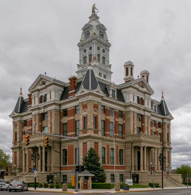
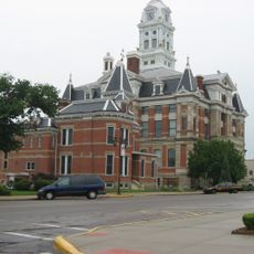
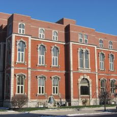
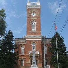
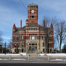
Napoleon is the county seat of Henry County in Ohio and serves as the administrative center of the region. The town features classic buildings from different eras along its streets, with local shops, churches, and a courthouse that reflect its role as the main gathering place for the area.

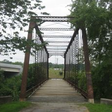
The town was founded in the early 1830s and grew rapidly due to its location along the Miami and Erie Canal and two railroad lines. By the late 1800s, this transportation advantage had brought thousands of residents and factories that supported the surrounding farming region.

The town's name reflects its historical connection to a figure from the past, shaping local identity and pride. Residents gather regularly at community events and festivals throughout the year, making local traditions and ways of life visible to visitors walking through the streets.

Visitors will find this a walkable town with a clear street layout and friendly locals who are helpful with directions. The visitor bureau and courthouse downtown serve as good landmarks to orient yourself as you explore the local shops and community spaces.

The town was once a manufacturing hub for farm tools and agricultural equipment, a chapter of history that many visitors overlook. Remnants of this industrial past still appear in the architecture and layout of the town, reflecting a time when the local economy centered on serving farming communities.

The community of curious travelers

AroundUs brings together thousands of curated places, local tips, and hidden gems, enriched daily by 60,000 contributors worldwide.

Start exploring
Location
Inception
1834
Elevation above the sea
207 m
GPS coordinates
41.39194,-84.12667
Latest update
February 17, 2026 01:20
Around this place
Fort Defiance
United States of America

Fort Defiance

22.5 km
Oak Openings Preserve Metropark
United States of America

Oak Openings Preserve Metropark

29.1 km
Mary Jane Thurston State Park
United States of America

Mary Jane Thurston State Park

20.9 km
Farnsworth Metropark
United States of America

Farnsworth Metropark

34.6 km
Goll Woods State Nature Preserve
United States of America

Goll Woods State Nature Preserve

26.5 km
Independence Dam State Park
United States of America

Independence Dam State Park

17 km
Harrison Lake State Park
United States of America

Harrison Lake State Park

34.4 km
Interurban Bridge
United States of America

Interurban Bridge

34.9 km
Henry County Sheriff's Residence and Jail
United States of America

Henry County Sheriff's Residence and Jail

263 m
Dodge Site
United States of America

Dodge Site

34.7 km
Henry County Courthouse
United States of America

Henry County Courthouse

223 m
John Edwards House
United States of America

John Edwards House

34.3 km
Defiance County Courthouse
United States of America

Defiance County Courthouse

22.9 km
Fulton County Courthouse
United States of America

Fulton County Courthouse

17.1 km
Leipsic Village Hall
United States of America

Leipsic Village Hall

34.8 km
Defiance Public Library
United States of America

Defiance Public Library

22.6 km
Goll Homestead
United States of America

Goll Homestead

27 km
Williams County Courthouse
United States of America

Williams County Courthouse

37.5 km
Dey Road Bridge
United States of America

Dey Road Bridge

24.4 km
First Universalist Church of Lyons, Ohio
United States of America

First Universalist Church of Lyons, Ohio

34.6 km
Murray D. Van Wagoner Memorial Bridge
United States of America

Murray D. Van Wagoner Memorial Bridge

36.3 km
Brooke Site
United States of America

Brooke Site

28.2 km
George S. Clement House
United States of America

George S. Clement House

17.6 km
Jones-Read-Touvelle House
United States of America

Jones-Read-Touvelle House

16.9 km
Fallen Timbers 14 + XD
United States of America

Fallen Timbers 14 + XD

39.1 km
Wintergarden Park
United States of America

Wintergarden Park

38.1 km
Riverside Chapel
United States of America

Riverside Chapel

24.8 km
Lockport Covered Bridge
United States of America

Lockport Covered Bridge

28 km
Show the full map
Reviews
Share your experience

No review yet

Discussions
Start a discussion...

No discussion yet

« Napoleon - city in and the county seat of Henry County, Ohio, United States » is provided by Around Us (aroundus.com). Images and texts are derived from Wikimedia project under a Creative Commons license. You are allowed to copy, distribute, and modify copies of this page, under the conditions set by the license, as long as this note is clearly visible.

Discover hidden gems everywhere you go!

From secret cafés to breathtaking viewpoints, skip the crowded tourist spots and find places that match your style. Our app makes it easy with voice search, smart filtering, route optimization, and insider tips from travelers worldwide. Download now for the complete mobile experience.

Around Us App Screenshot

A unique approach to discovering new places

Le Figaro

All the places worth exploring

France Info

A tailor-made excursion in just a few clicks

20 Minutes

Around Us
Travel Guide & Maps
Download

Send to your phone

QR Code
1

Open the camera app on your mobile.

2

Point at the QR code with your camera. A notification will appear.

3

Tap the notification to open the link.