Enable Location

We need your location to show you interesting places around you

Discover nearby places

Find interesting locations and hidden gems around you

Precise directions

Get accurate directions and distances to places

Your location is never shared with other users. It's only used when you tap the location button.

Canal Street railroad bridge

Log in to your account

Start exploring — it's free

Trusted by 62,597 travelers worldwide

Continue with Google
Continue with Apple
or

We will send you a code to connect

By continuing, you accept our Terms and Conditions and our Privacy Policy

Check your inbox

We've sent a pincode in your inbox. Please enter the code below.

Canal Street railroad bridge

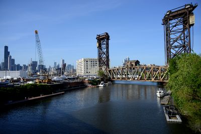
Canal Street railroad bridge, Vertical-lift railroad bridge in Chicago, US

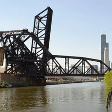
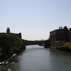
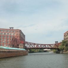
The Canal Street railroad bridge is a steel structure with a vertical-lift mechanism that crosses the South Branch of the Chicago River. Two rail tracks run at a steep angle to the waterway, creating a distinctive geometric arrangement above the flow.

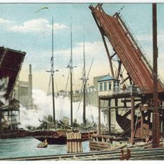
Engineers Waddell and Harrington designed the structure in 1914, with completion in 1915. It replaced an older swing bridge but was cleverly built above the existing structure to avoid interrupting rail service during construction.

The bridge takes its name from Canal Street, reflecting the waterway infrastructure that developed in this part of the city. It remains part of the working rail network that shapes how the city moves people across the river each day.

The lifting mechanism raises the deck about 40 meters when vessels need to pass underneath. Visitors can see the bridge from various points along the riverbank, and the best views come from walking the Chicago River pathways on either the north or south side.

When completed, the main span weighed about 1500 tons, making it the heaviest vertical-lift bridge span built anywhere in the country at that time. This extraordinary feat of steel construction made it a technical marvel of its era.

The community of curious travelers

AroundUs brings together thousands of curated places, local tips, and hidden gems, enriched daily by 60,000 contributors worldwide.

Start exploring
Location
Inception
July 30, 1914
GPS coordinates
41.85560,-87.63700
Latest update
December 11, 2025 18:02
Around this place
John J. Glessner House
United States of America

John J. Glessner House

1.3 km
Henry B. Clarke House
United States of America

Henry B. Clarke House

1.3 km
The 78
United States of America

The 78

1.1 km
Pacific Garden Mission
United States of America

Pacific Garden Mission

749 m
Thalia Hall
United States of America

Thalia Hall

1.7 km
Ping Tom Memorial Park
United States of America

Ping Tom Memorial Park

239 m
Pui Tak Center
United States of America

Pui Tak Center

542 m
Motor Row District
United States of America

Motor Row District

1.1 km
R.R. Donnelley and Sons Co. Calumet Plant
United States of America

R.R. Donnelley and Sons Co. Calumet Plant

1.6 km
Chinatown Square
United States of America

Chinatown Square

375 m
Second Presbyterian Church
United States of America

Second Presbyterian Church

1 km
St. Charles Air Line Bridge
United States of America

St. Charles Air Line Bridge

618 m
William W. Kimball House
United States of America

William W. Kimball House

1.4 km
Coca-Cola Building
United States of America

Coca-Cola Building

1.4 km
Harriet F. Rees House
United States of America

Harriet F. Rees House

1.4 km
UIC Skyspace
United States of America

UIC Skyspace

1.5 km
Wheeler-Kohn House
United States of America

Wheeler-Kohn House

1.5 km
Taylor Street Bridge
United States of America

Taylor Street Bridge

1.6 km
Maxwell-Briscoe Automobile Company Showroom
United States of America

Maxwell-Briscoe Automobile Company Showroom

1.2 km
Reid House
United States of America

Reid House

1.4 km
Cermak Road Bridge Historic District
United States of America

Cermak Road Bridge Historic District

431 m
Roosevelt/Wabash
United States of America

Roosevelt/Wabash

1.6 km
Chinese American Museum of Chicago
United States of America

Chinese American Museum of Chicago

579 m
Cermak Road Bridge
United States of America

Cermak Road Bridge

425 m
Clarke-Ford House
United States of America

Clarke-Ford House

1.3 km
Chicago Public Library Chinatown Branch
United States of America

Chicago Public Library Chinatown Branch

445 m
The Platt Luggage Company Building
United States of America

The Platt Luggage Company Building

1.5 km
American Book Company Building
United States of America

American Book Company Building

1.5 km
Show the full map
« Canal Street railroad bridge - Vertical-lift railroad bridge in Chicago, US » is provided by Around Us (aroundus.com). Images and texts are derived from Wikimedia project under a Creative Commons license. You are allowed to copy, distribute, and modify copies of this page, under the conditions set by the license, as long as this note is clearly visible.

Discover hidden gems everywhere you go!

From secret cafés to breathtaking viewpoints, skip the crowded tourist spots and find places that match your style. Our app makes it easy with voice search, smart filtering, route optimization, and insider tips from travelers worldwide. Download now for the complete mobile experience.

Around Us App Screenshot

A unique approach to discovering new places

Le Figaro

All the places worth exploring

France Info

A tailor-made excursion in just a few clicks

20 Minutes

Around Us
Travel Guide & Maps
Download

Send to your phone

QR Code
1

Open the camera app on your mobile.

2

Point at the QR code with your camera. A notification will appear.

3

Tap the notification to open the link.