Enable Location

We need your location to show you interesting places around you

Discover nearby places

Find interesting locations and hidden gems around you

Precise directions

Get accurate directions and distances to places

Your location is never shared with other users. It's only used when you tap the location button.

Charles River Reservation

Log in to your account

Start exploring — it's free

Trusted by 61,457 travelers worldwide

Continue with Google
Continue with Apple
or

We will send you a code to connect

By continuing, you accept our Terms and Conditions and our Privacy Policy

Check your inbox

We've sent a pincode in your inbox. Please enter the code below.

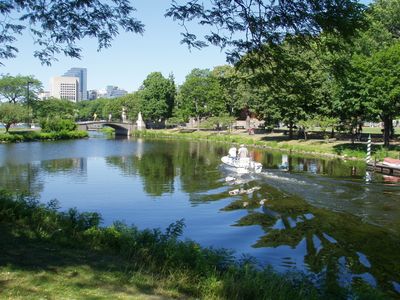
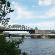
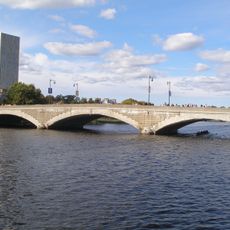
Charles River Reservation, Protected landscape along Charles River in Boston, US

Description

Charles River Reservation is a protected landscape along the Charles River that extends through multiple Massachusetts communities, offering riverside paths, sports fields, and natural areas. The various sections provide access to the water and surrounding green space for walking, cycling, and outdoor recreation.

History

This space was established in 1910 following the construction of a dam on the Charles River, which created a freshwater basin. The damming project transformed the riverfront and set the foundation for what would become a protected landscape managed by the state.

Culture

The area carries deep meaning for the community as a gathering place for outdoor activities and reflection. People use the paths and open spaces year-round, making it a visible part of daily life for nearby residents.

Practical

The reservation is open from sunrise to sunset, with parking areas and boat launches located at various points along the route. Multiple access points throughout the park make it easy to find a spot suited to your planned activity.

Did you know?

A specialized tactile trail near Irving Street in Watertown lets people with visual impairments explore the natural surroundings independently. This accessible pathway demonstrates how the reservation accommodates visitors with different needs.

Location
Location
Inception
1910
Operator
Massachusetts Department of Conservation and Recreation
GPS coordinates
42.35417,-71.11778
Latest update
December 9, 2025 18:45

AroundUs brings together thousands of curated places, local tips, and hidden gems, enriched daily by 60,000 contributors worldwide. Discover all places nearby (Middlesex County).

Around this place
Nickerson Field
United States of America

Nickerson Field

148 m
Agganis Arena
United States of America

Agganis Arena

219 m
Paradise Rock Club
United States of America

Paradise Rock Club

289 m
Boston University Bridge
United States of America

Boston University Bridge

615 m
Case Gym
United States of America

Case Gym

214 m
Shell Oil Company "Spectacular" Sign
United States of America

Shell Oil Company "Spectacular" Sign

322 m
Saint Aidan's Church and Rectory
United States of America

Saint Aidan's Church and Rectory

759 m
Fort Washington
United States of America

Fort Washington

1.1 km
George Sherman Union
United States of America

George Sherman Union

804 m
United States of America

West Campus

180 m
Grand Junction Railroad Bridge
United States of America

Grand Junction Railroad Bridge

639 m
United States of America

Boston Playwrights' Theatre

285 m
Cottage Farm Historic District
United States of America

Cottage Farm Historic District

872 m
The Underground
United States of America

The Underground

657 m
River Street Bridge
United States of America

River Street Bridge

788 m
The Allston Mall
United States of America

The Allston Mall

1 km
Western Avenue Bridge
United States of America

Western Avenue Bridge

1.1 km
Honan-Allston Branch Library
United States of America

Honan-Allston Branch Library

1.1 km
Saint Paul's Church, Chapel, and Parish House
United States of America

Saint Paul's Church, Chapel, and Parish House

901 m
Andrew Newman House
United States of America

Andrew Newman House

986 m
Edmund Reardon House
United States of America

Edmund Reardon House

1 km
Ernst Flentje House
United States of America

Ernst Flentje House

712 m
Saint Paul's Rectory
United States of America

Saint Paul's Rectory

898 m
Hastings Square Historic District
United States of America

Hastings Square Historic District

686 m
Graffam Development Historic District
United States of America

Graffam Development Historic District

588 m
Emmett Cottage
United States of America

Emmett Cottage

740 m
Mugar Memorial Library
United States of America

Mugar Memorial Library

878 m
John F. Kennedy Birthplace
United States of America

John F. Kennedy Birthplace

921 m
Show the full map
« Charles River Reservation - Protected landscape along Charles River in Boston, US » is provided by Around Us (aroundus.com). Images and texts are derived from Wikimedia project under a Creative Commons license. You are allowed to copy, distribute, and modify copies of this page, under the conditions set by the license, as long as this note is clearly visible.

Discover hidden gems everywhere you go!

From secret cafés to breathtaking viewpoints, skip the crowded tourist spots and find places that match your style. Our app makes it easy with voice search, smart filtering, route optimization, and insider tips from travelers worldwide. Download now for the complete mobile experience.

Around Us App Screenshot

A unique approach to discovering new places

Le Figaro

All the places worth exploring

France Info

A tailor-made excursion in just a few clicks

20 Minutes

Around Us
Travel Guide & Maps
Download

Send to your phone

QR Code
1

Open the camera app on your mobile.

2

Point at the QR code with your camera. A notification will appear.

3

Tap the notification to open the link.