·

Enable Location

We need your location to show you interesting places around you

Discover nearby places

Find interesting locations and hidden gems around you

Precise directions

Get accurate directions and distances to places

Your location is never shared with other users. It's only used when you tap the location button.

Eldora Speedway

Log in to your account

Start exploring — it's free

Trusted by 62,713 travelers worldwide

Continue with Google
Continue with Apple
or

We will send you a code to connect

By continuing, you accept our Terms and Conditions and our Privacy Policy

Check your inbox

We've sent a pincode in your inbox. Please enter the code below.

Eldora Speedway

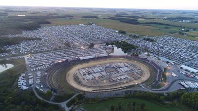
Eldora Speedway, Motorsport racing track in Rossburg, Ohio, US

Eldora Speedway is a racing circuit on a half mile dirt oval roughly 60 miles north of Dayton. The outer turns rise at an angle that allows vehicles to carry momentum through the high banks, while the straightaways run lower and wider.

A farmer leveled his cornfield in 1954 and built a circuit for local races, which expanded gradually over the following decades. A former driver and later champion took over the property in the early 2000s and added more seating and technical facilities.

The track draws drivers and spectators from many states who settle in for a long weekend in rural Ohio. During major events, campers and tents fill the grounds as visitors spend time together before and after the races.

Visitors should plan for sun protection and comfortable shoes, as the ground can be uneven and dust clouds are common during dry conditions. The main grandstands offer shade, but many seats remain exposed to the weather.

The surface comes from clay near the Wabash River and is constantly worked to adjust grip and handling for changing weather. Mechanics often use tire compounds specially developed for dirt tracks, which differ noticeably from those on asphalt.

The community of curious travelers

AroundUs brings together thousands of curated places, local tips, and hidden gems, enriched daily by 60,000 contributors worldwide.

Start exploring
Location
GPS coordinates
40.31861,-84.63389
Latest update
December 14, 2025 20:09
Around this place
Fort Recovery
United States of America

Fort Recovery

16.4 km
St. Charles Seminary
United States of America

St. Charles Seminary

14 km
Lake Loramie State Park
United States of America

Lake Loramie State Park

21.3 km
Shrine of the Holy Relics
United States of America

Shrine of the Holy Relics

17.2 km
St. John the Baptist Catholic Church
United States of America

St. John the Baptist Catholic Church

16.9 km
Nativity of the Blessed Virgin Mary Catholic Church
United States of America

Nativity of the Blessed Virgin Mary Catholic Church

12.1 km
St. Sebastian's Catholic Church
United States of America

St. Sebastian's Catholic Church

17.2 km
Garst Museum
United States of America

Garst Museum

23.6 km
Precious Blood Catholic Church
United States of America

Precious Blood Catholic Church

17.7 km
Darke County Courthouse, Sheriff's House and Jail
United States of America

Darke County Courthouse, Sheriff's House and Jail

24.3 km
Greenville Carnegie Library
United States of America

Greenville Carnegie Library

24.4 km
Minster Elementary School
United States of America

Minster Elementary School

23.2 km
Waring House
United States of America

Waring House

24.4 km
Lambert-Parent House
United States of America

Lambert-Parent House

19.2 km
William Kerr House
United States of America

William Kerr House

19.7 km
Versailles Town Hall and Wayne Township House
United States of America

Versailles Town Hall and Wayne Township House

16.6 km
Lansdowne House
United States of America

Lansdowne House

23.9 km
Broadway Bridge
United States of America

Broadway Bridge

23.9 km
St. Peter's Evangelical Lutheran Church
United States of America

St. Peter's Evangelical Lutheran Church

19.8 km
Union City Public Library
United States of America

Union City Public Library

19.7 km
Matthias Gast House
United States of America

Matthias Gast House

17.1 km
Donovan Robeson House
United States of America

Donovan Robeson House

24.5 km
Union City School
United States of America

Union City School

20.2 km
Anna Beir House
United States of America

Anna Beir House

24.1 km
Greenville Mausoleum
United States of America

Greenville Mausoleum

23.6 km
Wallischeck Homestead
United States of America

Wallischeck Homestead

19.9 km
Brown Township Building
United States of America

Brown Township Building

12.6 km
William English House
United States of America

William English House

16.6 km
Show the full map
« Eldora Speedway - Motorsport racing track in Rossburg, Ohio, US » is provided by Around Us (aroundus.com). Images and texts are derived from Wikimedia project under a Creative Commons license. You are allowed to copy, distribute, and modify copies of this page, under the conditions set by the license, as long as this note is clearly visible.

Discover hidden gems everywhere you go!

From secret cafés to breathtaking viewpoints, skip the crowded tourist spots and find places that match your style. Our app makes it easy with voice search, smart filtering, route optimization, and insider tips from travelers worldwide. Download now for the complete mobile experience.

Around Us App Screenshot

A unique approach to discovering new places

Le Figaro

All the places worth exploring

France Info

A tailor-made excursion in just a few clicks

20 Minutes

Around Us
Travel Guide & Maps
Download

Send to your phone

QR Code
1

Open the camera app on your mobile.

2

Point at the QR code with your camera. A notification will appear.

3

Tap the notification to open the link.