ARMOR Doppler Weather Radar

Log in to your account

AroundUs is a community-driven map of interesting places, built by curious explorers like you. It grows with every review, story, and photo you share.
Connect to save your favorite spots, contribute locations, and create personalized routes.
Continue with Google
Continue with Apple
Continue with X
Continue with Facebook
Continue with email
By continuing, you accept our Terms and Conditions and our Privacy Policy
Create an account

ARMOR Doppler Weather Radar

Add to collection
Map
Suggest a change
Share

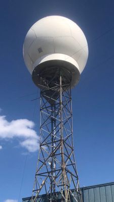
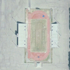
ARMOR Doppler Weather Radar, Research weather radar at Huntsville International Airport, US

ARMOR is a research weather radar system at Huntsville International Airport that monitors weather patterns across the region. The system uses dual-polarimetric technology to gather detailed information about precipitation and atmospheric conditions.

The system began as a National Weather Service radar in 1977 and received Doppler upgrades in 1991 to improve storm detection. Additional enhancements in 2004 added dual-polarimetric capabilities for more detailed atmospheric analysis.

The radar is operated by the University of Alabama in Huntsville and a local television station for meteorological research and education purposes. This partnership allows the region to gather advanced weather data that supports scientific advancement in storm study.

The radar is located on airport grounds and is not open to the public, but its research data is freely available online. Those interested in storm research can access the collected information through university websites and weather databases.

Data from this radar contributes to international satellite missions focused on measuring precipitation patterns worldwide. This global collaboration allows the findings to support environmental monitoring and cloud physics research beyond the local region.

Location: Huntsville

Elevation above the sea: 206 m

Diameter: 3.7 m

Part of: University of Alabama in Huntsville

GPS coordinates: 34.64614,-86.77153

Latest update: December 12, 2025 12:00

Photos
Around this place
U.S. Space & Rocket Center
United States of America

U.S. Space & Rocket Center

13 km
United States Space Camp
United States of America

United States Space Camp

13.1 km
Von Braun Center
United States of America

Von Braun Center

18.8 km
Neutral Buoyancy Simulator
United States of America

Neutral Buoyancy Simulator

8.7 km
Wheeler National Wildlife Refuge
United States of America

Wheeler National Wildlife Refuge

19.2 km
Milton Frank Stadium
United States of America

Milton Frank Stadium

16.8 km
Lowe Mill
United States of America

Lowe Mill

17.3 km
Belle Mina
United States of America

Belle Mina

10 km
Huntsville Museum of Art
United States of America

Huntsville Museum of Art

19.1 km
Shelta Cave
United States of America

Shelta Cave

19 km
Huntsville-Madison County Public Library
United States of America

Huntsville-Madison County Public Library

18.7 km
Captain William J. Hudson "Steamboat Bill" Memorial Bridges
United States of America

Captain William J. Hudson "Steamboat Bill" Memorial Bridges

18.9 km
Alabama Constitution Village
United States of America

Alabama Constitution Village

19.2 km
Merrimack Mill Village Historic District
United States of America

Merrimack Mill Village Historic District

16 km
Russel Erskine Hotel
United States of America

Russel Erskine Hotel

19.3 km
Wheeler National Wildlife Refuge Warden's Residence
United States of America

Wheeler National Wildlife Refuge Warden's Residence

8.1 km
William Lanford House
United States of America

William Lanford House

10.4 km
Somerville Courthouse
United States of America

Somerville Courthouse

19.2 km
Humphreys-Rodgers House
United States of America

Humphreys-Rodgers House

19.3 km
Madison Station Historic District
United States of America

Madison Station Historic District

6 km
James H. Bibb House
United States of America

James H. Bibb House

5.4 km
Kelly Brothers and Rowe Building
United States of America

Kelly Brothers and Rowe Building

19.4 km
Davidson Center for Space Exploration
United States of America

Davidson Center for Space Exploration

12.7 km
Green Pryor Rice House
United States of America

Green Pryor Rice House

19.3 km
U.S. Veterans Memorial Museum
United States of America

U.S. Veterans Memorial Museum

17.7 km
Huntsville Botanical Garden
United States of America

Huntsville Botanical Garden

14.4 km
Davidson Center for Space Exploration
United States of America

Davidson Center for Space Exploration

12.7 km
Show the full map
Reviews

Visited this place? Tap the stars to rate it and share your experience / photos with the community! Try now! You can cancel it anytime.

« ARMOR Doppler Weather Radar - Research weather radar at Huntsville International Airport, US » is provided by Around Us (aroundus.com). Images and texts are derived from Wikimedia project under a Creative Commons license. You are allowed to copy, distribute, and modify copies of this page, under the conditions set by the license, as long as this note is clearly visible.

Discover hidden gems everywhere you go!

From secret cafés to breathtaking viewpoints, skip the crowded tourist spots and find places that match your style. Our app makes it easy with voice search, smart filtering, route optimization, and insider tips from travelers worldwide. Download now for the complete mobile experience.

Around Us App Screenshot

A unique approach to discovering new places

Le Figaro

All the places worth exploring

France Info

A tailor-made excursion in just a few clicks

20 Minutes