Chest opened
+${chestReward.xp} XP
Explorer
NOUVEAU ×${chestReward.collectible.quantity}
tapez pour fermer
Chest locked

Open chests in the app

Around Us is built for your phone — chests unlock when you walk, explore and capture nearby places.

Enable Location

We need your location to show you interesting places around you

Discover nearby places

Find interesting locations and hidden gems around you

Precise directions

Get accurate directions and distances to places

Your location is never shared with other users. It's only used when you tap the location button.

Monticello Nuclear Generating Plant

Log in to your account

Start exploring — it's free

Trusted by 72,980 travelers worldwide

Continue with Google
Continue with Apple
or

We will send you a code to connect

By continuing, you accept our Terms and Conditions and our Privacy Policy

Check your inbox

We've sent a pincode in your inbox. Please enter the code below.

Monticello Nuclear Generating Plant
Discussion Reviews 1 Photos
17.7k Popularity

Monticello Nuclear Generating Plant, nuclear power plant

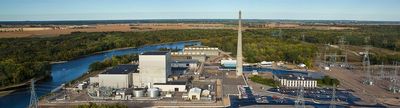
Monticello Nuclear Generating Plant is a power generation facility in Monticello, Minnesota, located about 35 miles (56 kilometers) northwest of Minneapolis. It operates a boiling water reactor that heats water to steam, which drives turbines to produce electricity for the region.

The plant received its first license in 1970 and began operating with a license in 1981, valid through 2030. Over the decades, it has maintained strict safety standards and underwent additional reviews following major incidents like Fukushima to strengthen its safety protocols.

Visitors should know that the facility is secured with barriers and signage marking restricted areas for safety reasons. Advance permission and arrangements are typically required to visit, as the site maintains strict access controls and security protocols.

The plant employs around 640 workers, making it one of the area's major employers and a key part of the local economy. Its Mark I containment design was developed by General Electric and represents a reactor type still in use today despite post-Fukushima safety reviews.

The community of curious travelers

AroundUs brings together thousands of curated places, local tips, and hidden gems, enriched daily by 60,000 contributors worldwide.

Start exploring
Location
GPS coordinates
45.33360,-93.84920
Latest update
February 17, 2026 00:20
Around this place
Sherburne National Wildlife Refuge
United States of America

Sherburne National Wildlife Refuge

20.6 km
The Crossing Church
United States of America

The Crossing Church

23.3 km
Church of St. Michael-Catholic
United States of America

Church of St. Michael-Catholic

19.9 km
Tobias G. Mealey House
United States of America

Tobias G. Mealey House

6.4 km
Rand House
United States of America

Rand House

6.4 km
Hanover Bridge
United States of America

Hanover Bridge

24.9 km
Betty Adkins Bridge
United States of America

Betty Adkins Bridge

23.3 km
Thayer Hotel
United States of America

Thayer Hotel

23.1 km
Church of St. Mary Help of Christians-Catholic
United States of America

Church of St. Mary Help of Christians-Catholic

28.7 km
Sparre Barn
United States of America

Sparre Barn

29.8 km
Marysville Swedesburg Lutheran Church
United States of America

Marysville Swedesburg Lutheran Church

25.6 km
Ames-Florida House
United States of America

Ames-Florida House

29 km
Fair Haven Flour Mill
United States of America

Fair Haven Flour Mill

28.7 km
Dr. E.P. Hawkins Clinic, Hospital, and House
United States of America

Dr. E.P. Hawkins Clinic, Hospital, and House

30 km
Parrish Avenue Bridge
United States of America

Parrish Avenue Bridge

22.5 km
Clearwater Masonic Lodge
United States of America

Clearwater Masonic Lodge

18.5 km
Babcock Memorial Park
United States of America

Babcock Memorial Park

23.4 km
Herbert M. Fox House
United States of America

Herbert M. Fox House

21.1 km
First Congregational Church of Clearwater
United States of America

First Congregational Church of Clearwater

18.4 km
District No. 48 School
United States of America

District No. 48 School

30 km
Nicherson–Tarbox House
United States of America

Nicherson–Tarbox House

5.9 km
William W. Webster House
United States of America

William W. Webster House

18.6 km
Cota Round Barns
United States of America

Cota Round Barns

28.4 km
St. Mark's Episcopal Chapel
United States of America

St. Mark's Episcopal Chapel

20.2 km
Oliver H. Kelley Farm
United States of America

Oliver H. Kelley Farm

25.7 km
Sand Dunes State Forest
United States of America

Sand Dunes State Forest

14.7 km
Lake Maria State Park
United States of America

Lake Maria State Park

8.7 km
Oliver H. Kelley Homestead
United States of America

Oliver H. Kelley Homestead

25.8 km
Show the full map
Reviews
Share your experience

No review yet

Discussions
Start a discussion...

No discussion yet

« Monticello Nuclear Generating Plant - nuclear power plant » is provided by Around Us (aroundus.com). Images and texts are derived from Wikimedia project under a Creative Commons license. You are allowed to copy, distribute, and modify copies of this page, under the conditions set by the license, as long as this note is clearly visible.

Discover hidden gems everywhere you go!

From secret cafés to breathtaking viewpoints, skip the crowded tourist spots and find places that match your style. Our app makes it easy with voice search, smart filtering, route optimization, and insider tips from travelers worldwide. Download now for the complete mobile experience.

Around Us App Screenshot

A unique approach to discovering new places

Le Figaro

All the places worth exploring

France Info

A tailor-made excursion in just a few clicks

20 Minutes

Around Us
Travel Guide & Maps
Download

Send to your phone

QR Code
1

Open the camera app on your mobile.

2

Point at the QR code with your camera. A notification will appear.

3

Tap the notification to open the link.