Enable Location

We need your location to show you interesting places around you

Discover nearby places

Find interesting locations and hidden gems around you

Precise directions

Get accurate directions and distances to places

Your location is never shared with other users. It's only used when you tap the location button.

Betty Adkins Bridge

Log in to your account

Start exploring — it's free

Trusted by 62,099 travelers worldwide

Continue with Google
Continue with Apple
or

We will send you a code to connect

By continuing, you accept our Terms and Conditions and our Privacy Policy

Check your inbox

We've sent a pincode in your inbox. Please enter the code below.

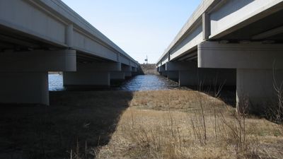
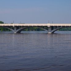
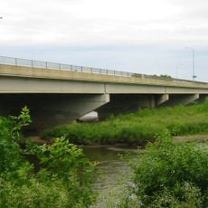
Betty Adkins Bridge, Concrete girder bridge in Otsego, United States.

The Betty Adkins Bridge is a four-lane highway bridge made of concrete that crosses the Mississippi River between Otsego and Elk River. The structure consists of two parallel sections that connect these two Minnesota cities.

The bridge was built in two phases: the southbound section opened in 1993 and eventually replaced an earlier 1967 girder bridge. The northbound section was added later to complete the modern dual structure.

This bridge was named after Betty Adkins, a Minnesota state senator who served in the legislature representing the Democratic-Farmer-Labor Party. It reflects how local infrastructure can honor figures from the region's political history.

The bridge carries regular traffic and provides adequate clearance for river traffic passing underneath. It is best viewed and crossed by vehicle as it is part of a busy highway corridor.

This structure handles approximately 46000 vehicles per day, making it a critical transportation link in the region. The dual design allows traffic to flow smoothly across the river in both directions.

The community of curious travelers

AroundUs brings together thousands of curated places, local tips, and hidden gems, enriched daily by 60,000 contributors worldwide.

Start exploring
Location
Location
Inception
2001
Official opening
2001
Made from material
concrete
GPS coordinates
45.28860,-93.55810
Latest update
December 14, 2025 18:09
Around this place
Coon Rapids High School
United States of America

Coon Rapids High School

21.7 km
The Crossing Church
United States of America

The Crossing Church

17.4 km
Church of St. Michael-Catholic
United States of America

Church of St. Michael-Catholic

12 km
Tobias G. Mealey House
United States of America

Tobias G. Mealey House

17.7 km
Rand House
United States of America

Rand House

17.8 km
Anoka-Champlin Mississippi River Bridge
United States of America

Anoka-Champlin Mississippi River Bridge

16.7 km
Windego Park Auditorium/Open Air Theater
United States of America

Windego Park Auditorium/Open Air Theater

16.5 km
Hanover Bridge
United States of America

Hanover Bridge

17.1 km
Brooklyn Park Library
United States of America

Brooklyn Park Library

24.5 km
Colonial Hall and Masonic Lodge No. 30
United States of America

Colonial Hall and Masonic Lodge No. 30

16.9 km
Osseo Water Tower
United States of America

Osseo Water Tower

22.3 km
Sparre Barn
United States of America

Sparre Barn

8.7 km
Champlin Library
United States of America

Champlin Library

18.1 km
Heman L. Ticknor House
United States of America

Heman L. Ticknor House

17 km
Parrish Avenue Bridge
United States of America

Parrish Avenue Bridge

1.6 km
Henry G. Leathers House
United States of America

Henry G. Leathers House

19 km
Babcock Memorial Park
United States of America

Babcock Memorial Park

170 m
Shaw–Hammons House
United States of America

Shaw–Hammons House

16.3 km
Nicherson–Tarbox House
United States of America

Nicherson–Tarbox House

18 km
District No. 28 School
United States of America

District No. 28 School

14.3 km
Oliver H. Kelley Farm
United States of America

Oliver H. Kelley Farm

3.5 km
Sand Dunes State Forest
United States of America

Sand Dunes State Forest

19.5 km
Oliver H. Kelley Homestead
United States of America

Oliver H. Kelley Homestead

3.6 km
Highway 25 Bridge
United States of America

Highway 25 Bridge

18.4 km
Porter Kelsey House
United States of America

Porter Kelsey House

15.2 km
Maple Grove Library
United States of America

Maple Grove Library

22.8 km
Elm Creek Park Reserve
United States of America

Elm Creek Park Reserve

17.1 km
Crow-Hassan Park Reserve
United States of America

Crow-Hassan Park Reserve

11.1 km
Show the full map
« Betty Adkins Bridge - Concrete girder bridge in Otsego, United States » is provided by Around Us (aroundus.com). Images and texts are derived from Wikimedia project under a Creative Commons license. You are allowed to copy, distribute, and modify copies of this page, under the conditions set by the license, as long as this note is clearly visible.

Discover hidden gems everywhere you go!

From secret cafés to breathtaking viewpoints, skip the crowded tourist spots and find places that match your style. Our app makes it easy with voice search, smart filtering, route optimization, and insider tips from travelers worldwide. Download now for the complete mobile experience.

Around Us App Screenshot

A unique approach to discovering new places

Le Figaro

All the places worth exploring

France Info

A tailor-made excursion in just a few clicks

20 Minutes

Around Us
Travel Guide & Maps
Download

Send to your phone

QR Code
1

Open the camera app on your mobile.

2

Point at the QR code with your camera. A notification will appear.

3

Tap the notification to open the link.