Guayama

Log in to your account

AroundUs is a community-driven map of interesting places, built by curious explorers like you. It grows with every review, story, and photo you share.
Connect to save your favorite spots, contribute locations, and create personalized routes.
Continue with Google
Continue with Apple
Continue with X
Continue with Facebook
Continue with email
By continuing, you accept our Terms and Conditions and our Privacy Policy
Create an account
Add to collection
Map
Suggest a change
Share

Guayama, Administrative division in southern Puerto Rico, United States.

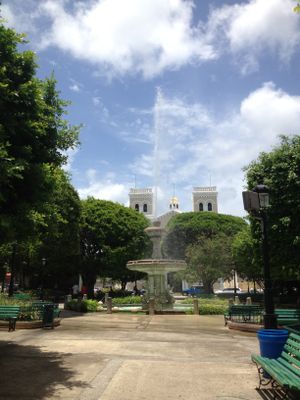
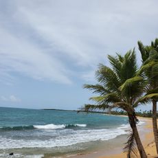
Guayama is a municipality in southern Puerto Rico that stretches from the Caribbean coastline to the central mountain range. The territory combines urban areas with natural landscapes within a compact regional space.

Spanish Governor Matías de Abadía established this administrative region in 1736 and initially named it San Antonio de Padua de Guayama after a Taíno leader. This founding event shaped the historical foundation of the municipality as it exists today.

Local residents share stories about baseball traditions and local legends that have earned the place its nickname 'Pueblo de los brujos' among communities across Puerto Rico. These tales remain an important part of daily conversation and community identity.

The Municipal Building serves as the central location for administrative services, while several banking institutions operate throughout the area to serve the population. Visitors should ask locally to learn about available services and their specific locations.

The region is home to notable geographical features including Cerro de la Tabla and Cerro Tumbado mountains. These peaks shape the natural profile of the area and remain visible from urban zones.

Location: Puerto Rico

Inception: January 29, 1736

Capital city: Guayama barrio-pueblo

Shares border with: Salinas, Arroyo, Patillas, Cayey

Website: http://gobierno.pr/OCAM/DirectorioMunicipios/Guayama.htm

GPS coordinates: 17.98413,-66.11378

Latest update: December 13, 2025 22:48

Photos
Around this place
Monumento al Jíbaro Puertorriqueño
United States of America

Monumento al Jíbaro Puertorriqueño

14.7 km
Casa Cautiño
United States of America

Casa Cautiño

190 m
United States of America

Carite Lake

10.3 km
United States of America

La Robleda Natural Protected Area

11.7 km
Punta de las Figuras Light
United States of America

Punta de las Figuras Light

7.7 km
United States of America

Aguirre State Forest

7.4 km
Cayey Bridge
United States of America

Cayey Bridge

2.1 km
United States of America

Juana Rodríguez Morales House

15.4 km
Eleuterio Derkes Grammar School
United States of America

Eleuterio Derkes Grammar School

324 m
Playa Pozuelo
United States of America

Playa Pozuelo

10 km
Olimpia Water Park
United States of America

Olimpia Water Park

14 km
La Casa del Cuento y de la Historia Cayeyana Ramón "Moncho" Gómez
United States of America

La Casa del Cuento y de la Historia Cayeyana Ramón "Moncho" Gómez

15.3 km
Casa y Museo del Poeta Luis Palés Matos
Puerto Rico

Casa y Museo del Poeta Luis Palés Matos

146 m
U Go Play
United States of America

U Go Play

2.1 km
United States of America

Área Recreativa Real Patillas

12 km
United States of America

Teatro Guayama

149 m
United States of America

Albergue Olímpico de Puerto Rico Germán Rieckehoff Sampayo

13.8 km
United States of America

Molino Vives

794 m
United States of America

Survivor Falls

12.3 km
United States of America

Ola Marina

14.1 km

Teatro Renacimiento

5.9 km
United States of America

Auditorio San Alfonso María de Ligorio

178 m

Teatro Calimano

50 m
United States of America

Molino de la Berdedera

6.5 km
United States of America

Tótem Memoria Urbana

371 m
United States of America

Busto de Luis Palés Matos

158 m
United States of America

Mural de José Rafael "Piculín" Ortiz Rijos

15.4 km

Scenic viewpoint

7.7 km
Show the full map
Reviews

Visited this place? Tap the stars to rate it and share your experience / photos with the community! Try now! You can cancel it anytime.

« Guayama - Administrative division in southern Puerto Rico, United States » is provided by Around Us (aroundus.com). Images and texts are derived from Wikimedia project under a Creative Commons license. You are allowed to copy, distribute, and modify copies of this page, under the conditions set by the license, as long as this note is clearly visible.

Discover hidden gems everywhere you go!

From secret cafés to breathtaking viewpoints, skip the crowded tourist spots and find places that match your style. Our app makes it easy with voice search, smart filtering, route optimization, and insider tips from travelers worldwide. Download now for the complete mobile experience.

Around Us App Screenshot

A unique approach to discovering new places

Le Figaro

All the places worth exploring

France Info

A tailor-made excursion in just a few clicks

20 Minutes