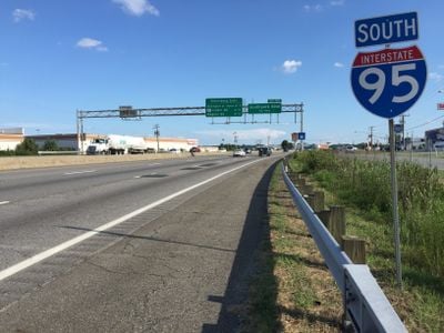
Interstate 95 in Virginia, Interstate highway in Virginia, United States.
Interstate 95 is a four-lane federal highway that stretches approximately 180 miles (290 km) through Virginia, connecting the North Carolina border in the south with the Maryland border in the north. The route passes through several major cities including Petersburg, Richmond, Fredericksburg, and Alexandria, serving as a primary corridor for regional and long-distance traffic.
Construction of this federal highway began in 1957 and incorporated existing road sections such as the Richmond-Petersburg Turnpike into the modern interstate system. Completion stretched over several decades, with different sections opening at various times.
The highway connects travelers to Civil War battlefields, museums, and national parks that document Virginia's role in American history.
Numerous rest areas along the route provide fuel, food, restrooms, and traveler information services. The best time to drive is outside rush hours, such as early morning or evening, to avoid congestion near urban areas.
A winter weather event in January 2022 blocked the highway for more than a day when heavy snowfall left hundreds of vehicles stranded. This incident shows how vulnerable even well-developed routes can be under extreme conditions.
Location: Virginia
Inception: 1957
Part of: Interstate 95
GPS coordinates: 38.56817,-77.33527
Latest update: December 6, 2025 21:27
Mallows Bay
12.1 km
National Museum of the Marine Corps
2.8 km
Weems–Botts Museum
435 m
Leesylvania State Park
6.6 km
Quantico National Cemetery
3.8 km
Bel Air
8.4 km
Marine Raider Museum
11.8 km
Aquia Church
13 km
Occoquan Bay National Wildlife Refuge
12.1 km
Smallwood State Park
13.1 km
Chopawamsic
7.5 km
Featherstone National Wildlife Refuge
7.5 km
Waffle House
1.7 km
Breckenridge Reservoir
6 km
Commanding General's Quarters, Quantico Marine Base
5.4 km
Marine Corps Air-Ground Museum
7.2 km
Freestone Point Confederate Battery
8 km
C.D. Hylton Senior High School
10 km
Henderson House
557 m
Pleasant Historic District, Chopawamsic RDA Camp 4
3.1 km
Cabin Branch Pyrite Mine Historic District
1.6 km
Chopawamsic Recreational Demonstration Area Cabin Camp 1
3.7 km
Chopawamsic RDA Camp 2
7.2 km
Old Town Hall and School
968 m
Orenda/SP-26 Historic District, Chopawamsic RDA Camp 3
2.2 km
Crusading for Right
6.2 km
Prince William Forest Park Visitor Center
1.4 km
Prince William Forest Park Historic District
3.1 kmReviews
Visited this place? Tap the stars to rate it and share your experience / photos with the community! Try now! You can cancel it anytime.
Discover hidden gems everywhere you go!
From secret cafés to breathtaking viewpoints, skip the crowded tourist spots and find places that match your style. Our app makes it easy with voice search, smart filtering, route optimization, and insider tips from travelers worldwide. Download now for the complete mobile experience.
A unique approach to discovering new places❞
— Le Figaro
All the places worth exploring❞
— France Info
A tailor-made excursion in just a few clicks❞
— 20 Minutes