Enable Location

We need your location to show you interesting places around you

Discover nearby places

Find interesting locations and hidden gems around you

Precise directions

Get accurate directions and distances to places

Your location is never shared with other users. It's only used when you tap the location button.

Weed Patch Hill

Log in to your account

Start exploring — it's free

Trusted by 62,166 travelers worldwide

Continue with Google
Continue with Apple
or

We will send you a code to connect

By continuing, you accept our Terms and Conditions and our Privacy Policy

Check your inbox

We've sent a pincode in your inbox. Please enter the code below.

Weed Patch Hill

Weed Patch Hill, Summit at Brown County State Park, Indiana

Weed Patch Hill is a summit located within Brown County State Park and rises to about 1,058 feet (322 meters) in Indiana's forested terrain. The hill forms part of the Knobstone Escarpment and ranks among the state's most elevated named peaks.

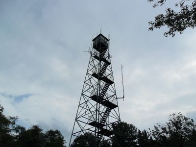
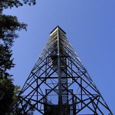
The name comes from early settlers who noticed weeds rapidly covering the slope after a tornado cleared the trees. A fire observation tower was built on the summit during the 1930s to monitor the forest below.

The fire tower constructed during the 1930s at the summit stands as a testament to Indiana's commitment to forest preservation and natural resource management.

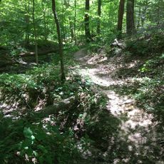
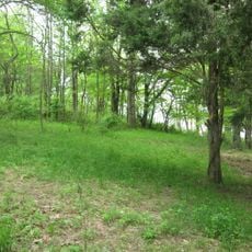
The hill is accessible through the park's trail network, which connects from several parking areas throughout the grounds. The walking routes offer varying difficulty levels depending on which path you choose.

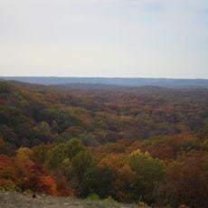
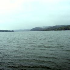
On clear days, distant hills in several directions become visible from this vantage point. The exposed location makes it a viewing spot where visitors can grasp the broader terrain and landscape layout of the region.

The community of curious travelers

AroundUs brings together thousands of curated places, local tips, and hidden gems, enriched daily by 60,000 contributors worldwide.

Start exploring
Location
Part of
Knobstone Escarpment
GPS coordinates
39.16699,-86.21749
Latest update
December 12, 2025 17:48
Around this place
Camp Atterbury
United States of America

Camp Atterbury

20.5 km
Brown County State Park
United States of America

Brown County State Park

7.2 km
Cummins Corporate Office Building
United States of America

Cummins Corporate Office Building

25.7 km
Eskenazi Museum of Art
United States of America

Eskenazi Museum of Art

25.8 km
Morgan–Monroe State Forest
United States of America

Morgan–Monroe State Forest

24.1 km
Hickory Ridge Fire Tower
United States of America

Hickory Ridge Fire Tower

17.2 km
United States of America

The Republic Newspaper Office

25.8 km
United States of America

Mill Race Park

25.4 km
T. C. Steele State Historic Site
United States of America

T. C. Steele State Historic Site

11.2 km
Millen House
United States of America

Millen House

25.1 km
Columbus Power House
United States of America

Columbus Power House

25.5 km
Grandview Apostolic Church
United States of America

Grandview Apostolic Church

12.4 km
Brown County Courthouse Historic District
United States of America

Brown County Courthouse Historic District

5.2 km
Morgantown Historic District
United States of America

Morgantown Historic District

23.3 km
Brownsville Covered Bridge
United States of America

Brownsville Covered Bridge

25.2 km
Brown County Bridge No. 36
United States of America

Brown County Bridge No. 36

7.6 km
Thomas A. Hendricks House
United States of America

Thomas A. Hendricks House

6.6 km
David Aikens House
United States of America

David Aikens House

24.8 km
Bean Blossom Covered Bridge
United States of America

Bean Blossom Covered Bridge

11 km
Brown County Art Gallery
United States of America

Brown County Art Gallery

4.9 km
Lake Lemon
United States of America

Lake Lemon

18.4 km
Brown County Art Guild
United States of America

Brown County Art Guild

5.1 km
Kappa V Archaeological Site
United States of America

Kappa V Archaeological Site

17 km
Robert N. Stewart Bridge
United States of America

Robert N. Stewart Bridge

25.5 km
Low Gap Trail
United States of America

Low Gap Trail

24 km
Ramp Creek Covered Bridge
United States of America

Ramp Creek Covered Bridge

3.2 km
Jonathan Moore Pike I-65 Bridge
United States of America

Jonathan Moore Pike I-65 Bridge

22.7 km
New Brownsville Bridge
United States of America

New Brownsville Bridge

25.3 km
Show the full map
« Weed Patch Hill - Summit at Brown County State Park, Indiana » is provided by Around Us (aroundus.com). Images and texts are derived from Wikimedia project under a Creative Commons license. You are allowed to copy, distribute, and modify copies of this page, under the conditions set by the license, as long as this note is clearly visible.

Discover hidden gems everywhere you go!

From secret cafés to breathtaking viewpoints, skip the crowded tourist spots and find places that match your style. Our app makes it easy with voice search, smart filtering, route optimization, and insider tips from travelers worldwide. Download now for the complete mobile experience.

Around Us App Screenshot

A unique approach to discovering new places

Le Figaro

All the places worth exploring

France Info

A tailor-made excursion in just a few clicks

20 Minutes

Around Us
Travel Guide & Maps
Download

Send to your phone

QR Code
1

Open the camera app on your mobile.

2

Point at the QR code with your camera. A notification will appear.

3

Tap the notification to open the link.