Enable Location

We need your location to show you interesting places around you

Discover nearby places

Find interesting locations and hidden gems around you

Precise directions

Get accurate directions and distances to places

Your location is never shared with other users. It's only used when you tap the location button.

Log in to your account

Start exploring — it's free

Trusted by 66,224 travelers worldwide

Continue with Google
Continue with Apple
or

We will send you a code to connect

By continuing, you accept our Terms and Conditions and our Privacy Policy

Check your inbox

We've sent a pincode in your inbox. Please enter the code below.

Massacre at Ywahoo Falls
Discussion Reviews Photo
3.5k Popularity

Massacre at Ywahoo Falls, Historic massacre site at Ywahoo Falls, Kentucky, United States.

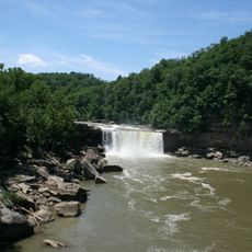
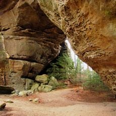
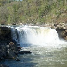
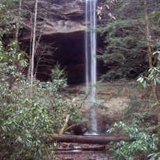
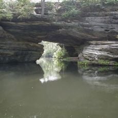
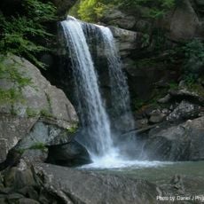
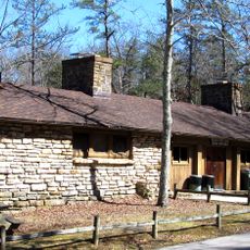
Ywahoo Falls is a location with steep cliffs and a waterfall within the Daniel Boone National Forest in southeastern Kentucky. The falls sit within a large rock shelter carved by water over a long span of time.

Local accounts describe European American soldiers killing Cherokee women and children at this location in 1810. The event marked a turning point in the violent conflicts between colonists and Native Americans in the region.

The site holds deep meaning for Native American communities as a place of remembrance for conflicts between Indigenous peoples and European settlers. Visitors can feel the connection between the natural landscape and this difficult chapter today.

The location is accessible through marked trails in the Daniel Boone National Forest, with rangers providing information at nearby stations. The terrain is rocky and steep, so sturdy footwear is recommended.

The waterfall has carved a natural amphitheater shape over thousands of years through the power of flowing water. This rock shelter is one of Kentucky's largest natural structures of its kind.

The community of curious travelers

AroundUs brings together thousands of curated places, local tips, and hidden gems, enriched daily by 60,000 contributors worldwide.

Start exploring
Location
GPS coordinates
36.76900,-84.51056
Latest update
December 12, 2025 07:55
Around this place
Cumberland Falls
United States of America

Cumberland Falls

16.7 km
Big South Fork National River and Recreation Area
United States of America

Big South Fork National River and Recreation Area

35.6 km
Cumberland Falls State Resort Park
United States of America

Cumberland Falls State Resort Park

17.8 km
Tombstone Junction
United States of America

Tombstone Junction

15.4 km
Yahoo Falls
United States of America

Yahoo Falls

4 m
Pickett Civilian Conservation Corps Memorial State Park
United States of America

Pickett Civilian Conservation Corps Memorial State Park

35.2 km
United States of America

Dog Slaughter Falls

20.3 km
Big South Fork Scenic Railway
United States of America

Big South Fork Scenic Railway

8.4 km
Eagle Falls
United States of America

Eagle Falls

17 km
Kentucky Splash Waterpark
United States of America

Kentucky Splash Waterpark

30.3 km
Mill Springs National Cemetery
United States of America

Mill Springs National Cemetery

39 km
McCreary County Museum
United States of America

McCreary County Museum

8.3 km
Mill Springs Mill
United States of America

Mill Springs Mill

30.2 km
Confederate Mass Grave Monument in Somerset
United States of America

Confederate Mass Grave Monument in Somerset

37.8 km
General Felix K. Zollicoffer Monument
United States of America

General Felix K. Zollicoffer Monument

37.8 km
Cumberland Inn Museum
United States of America

Cumberland Inn Museum

31.1 km
Old Wayne County High School
United States of America

Old Wayne County High School

31.9 km
Burnside Methodist Church
United States of America

Burnside Methodist Church

25.5 km
Burnside Masonic Lodge
United States of America

Burnside Masonic Lodge

25.6 km
Fairchild House
United States of America

Fairchild House

31.1 km
Lane Theater
United States of America

Lane Theater

31.2 km
Somerset Downtown Commercial District
United States of America

Somerset Downtown Commercial District

36.9 km
Stearns Administrative and Commercial District
United States of America

Stearns Administrative and Commercial District

8.4 km
Monticello Historic Commercial District
United States of America

Monticello Historic Commercial District

30.9 km
Withers House
United States of America

Withers House

37.1 km
Mill Springs Battlefield Visitor Center and Museum
United States of America

Mill Springs Battlefield Visitor Center and Museum

39 km
Pickett State Rustic Park Historic District
United States of America

Pickett State Rustic Park Historic District

35.6 km
Indian Mountain State Park
United States of America

Indian Mountain State Park

38.8 km
Show the full map
Reviews
Share your experience

No review yet

Discussions
Start a discussion...

No discussion yet

« Massacre at Ywahoo Falls - Historic massacre site at Ywahoo Falls, Kentucky, United States » is provided by Around Us (aroundus.com). Images and texts are derived from Wikimedia project under a Creative Commons license. You are allowed to copy, distribute, and modify copies of this page, under the conditions set by the license, as long as this note is clearly visible.

Discover hidden gems everywhere you go!

From secret cafés to breathtaking viewpoints, skip the crowded tourist spots and find places that match your style. Our app makes it easy with voice search, smart filtering, route optimization, and insider tips from travelers worldwide. Download now for the complete mobile experience.

Around Us App Screenshot

A unique approach to discovering new places

Le Figaro

All the places worth exploring

France Info

A tailor-made excursion in just a few clicks

20 Minutes

Around Us
Travel Guide & Maps
Download

Send to your phone

QR Code
1

Open the camera app on your mobile.

2

Point at the QR code with your camera. A notification will appear.

3

Tap the notification to open the link.