Porcupine Mountains

Log in to your account

AroundUs is a community-driven map of interesting places, built by curious explorers like you. It grows with every review, story, and photo you share.
Connect to save your favorite spots, contribute locations, and create personalized routes.
By continuing, you accept our Terms and Conditions and our Privacy Policy
Add to collection
Map
Suggest a change
Share

Porcupine Mountains, Nature reserve in Upper Peninsula, Michigan, United States

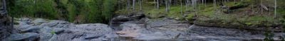
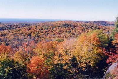
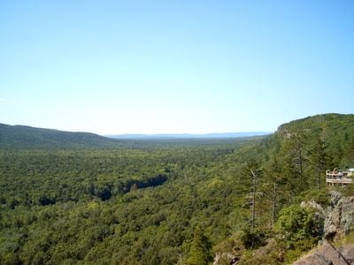
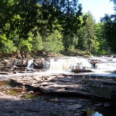
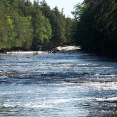
Porcupine Mountains is a nature reserve in Michigan's Upper Peninsula featuring old-growth forests, cascading waterfalls, and shoreline along Lake Superior. The terrain includes ridges and valleys interspersed with rivers and mountain slopes that create a varied landscape.

The area became a protected park in 1945 to preserve one of North America's largest remaining old-growth northern forests west of the Adirondack region. This decision reflected a growing focus on protecting intact woodlands during the middle of the twentieth century.

The Ojibwa people named these mountains after their silhouette, which resembles a crouching porcupine when viewed against the horizon. This naming tradition shows how indigenous communities understood and described the landscape around them.

Visitors have access to over 90 miles of hiking trails and a range of camping options from rustic cabins to modern facilities. The area offers swimming spots and ranger-led programs that run throughout the year.

The location receives extreme lake-effect snowfall from Lake Superior that accumulates heavily at higher elevations. These extraordinary winter conditions create exceptional opportunities for winter recreation and shape the landscape.

Location: Michigan

Elevation above the sea: 595 m

Made from material: basalt

Operator: Michigan Department of Natural Resources

Part of: Canadian Shield

Website: https://www2.dnr.state.mi.us/ParksandTrails/Details.aspx?id=426&type=SPRK

GPS coordinates: 46.76667,-89.75000

Latest update: December 6, 2025 21:22

Photos
Around this place
Show the full map
Copper mining in Michigan
United States of America

Copper mining in Michigan

16.9 km
Copper Peak
United States of America

Copper Peak

31.9 km
SS Ira H. Owen
United States of America

SS Ira H. Owen

30.3 km
Michigan Island Light
United States of America

Michigan Island Light

58.1 km
Ontonagon School
United States of America

Ontonagon School

35.4 km
Superior Falls
United States of America

Superior Falls

55.7 km
Ironwood Theatre
United States of America

Ironwood Theatre

47.3 km
O Kun de Kun Falls
United States of America

O Kun de Kun Falls

47.6 km
Ontonagon Light
United States of America

Ontonagon Light

35 km
Great Conglomerate Falls
United States of America

Great Conglomerate Falls

27.7 km
Manido Falls
United States of America

Manido Falls

18.2 km
Nawadaha Falls
United States of America

Nawadaha Falls

18.6 km
Ironwood Memorial/Municipal Building
United States of America

Ironwood Memorial/Municipal Building

47 km
Ironwood Carnegie Library
United States of America

Ironwood Carnegie Library

47.6 km
Ontonagon Harbor Piers Historic District
United States of America

Ontonagon Harbor Piers Historic District

35.6 km
Gogebic County Courthouse
United States of America

Gogebic County Courthouse

39.2 km
Ontonagon County Courthouse
United States of America

Ontonagon County Courthouse

35.5 km
Solomon S. Curry House
United States of America

Solomon S. Curry House

46.8 km
Annala Round Barn
United States of America

Annala Round Barn

50 km
Old Iron County Courthouse
United States of America

Old Iron County Courthouse

48.5 km
Bergland Administrative Site
United States of America

Bergland Administrative Site

23.5 km
Plummer Mine Headframe
United States of America

Plummer Mine Headframe

57.6 km
Planter Road – Jackson Creek Bridge
United States of America

Planter Road – Jackson Creek Bridge

32.8 km
Lake Gogebic State Park Beach
United States of America

Lake Gogebic State Park Beach

37.2 km
Ontonagon Township Park Beach
United States of America

Ontonagon Township Park Beach

36.8 km
Lake Gogebic State Park
United States of America

Lake Gogebic State Park

36.9 km
Porcupine Mountains Wilderness State Park
United States of America

Porcupine Mountains Wilderness State Park

1.8 km
Lake Gogebic
United States of America

Lake Gogebic

32.3 km
Show the full map
Reviews

Visited this place? Tap the stars to rate it and share your experience / photos with the community! Try now! You can cancel it anytime.

« Porcupine Mountains - Nature reserve in Upper Peninsula, Michigan, United States » is provided by Around Us (aroundus.com). Images and texts are derived from Wikimedia project under a Creative Commons license. You are allowed to copy, distribute, and modify copies of this page, under the conditions set by the license, as long as this note is clearly visible.

Discover hidden gems everywhere you go!

From secret cafés to breathtaking viewpoints, skip the crowded tourist spots and find places that match your style. Our app makes it easy with voice search, smart filtering, route optimization, and insider tips from travelers worldwide. Download now for the complete mobile experience.

Around Us App Screenshot

A unique approach to discovering new places

Le Figaro

All the places worth exploring

France Info

A tailor-made excursion in just a few clicks

20 Minutes