Enable Location

We need your location to show you interesting places around you

Discover nearby places

Find interesting locations and hidden gems around you

Precise directions

Get accurate directions and distances to places

Your location is never shared with other users. It's only used when you tap the location button.

Manido Falls

Log in to your account

Start exploring — it's free

Trusted by 62,449 travelers worldwide

Continue with Google
Continue with Apple
or

We will send you a code to connect

By continuing, you accept our Terms and Conditions and our Privacy Policy

Check your inbox

We've sent a pincode in your inbox. Please enter the code below.

Manido Falls

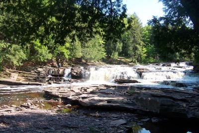
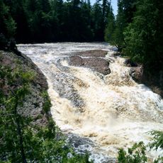
Manido Falls, waterfall

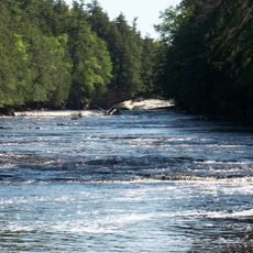
Manido Falls is a small waterfall in Michigan's Porcupine Mountains Wilderness State Park, located along the Presque Isle River. It features two main drops with a total height of about 15 feet, with water flowing into a small pool before continuing downstream over smaller rapids.

The waterfall's name originates from the Ojibwe culture of the region and is part of the natural history of the Porcupine Mountains area. The Presque Isle River has shaped the landscape over time, leaving the falls as a feature of the wilderness.

The name "Manido" comes from the Ojibwe language and means spirit or divine being. This reflects the area's respect for the natural world and the traditions of indigenous peoples.

A short, well-marked trail leads to the falls and is suitable for most visitors, including families with children. Wear sturdy shoes and watch for uneven ground and wet rocks near the water.

The falls transform dramatically with the seasons: in spring when snow melts, the water can spread over 100 feet wide as the river swells. During dry periods, the flow becomes narrower and quieter, creating a completely different experience.

The community of curious travelers

AroundUs brings together thousands of curated places, local tips, and hidden gems, enriched daily by 60,000 contributors worldwide.

Start exploring
Location
Part of
Presque Isle River
GPS coordinates
46.70403,-89.97068
Latest update
February 9, 2026 07:44
Around this place
Porcupine Mountains
United States of America

Porcupine Mountains

18.2 km
Copper mining in Michigan
United States of America

Copper mining in Michigan

34.9 km
Big Bay State Park
United States of America

Big Bay State Park

54.6 km
SS Ira H. Owen
United States of America

SS Ira H. Owen

23.5 km
Apostle Islands Lighthouses
United States of America

Apostle Islands Lighthouses

57.9 km
Michigan Island Light
United States of America

Michigan Island Light

44.3 km
Ontonagon School
United States of America

Ontonagon School

53.6 km
Superior Falls
United States of America

Superior Falls

37.4 km
Outer Island Light
United States of America

Outer Island Light

53.6 km
Ironwood Theatre
United States of America

Ironwood Theatre

31.7 km
United States of America

Kakagon Sloughs

59 km
Ontonagon Light
United States of America

Ontonagon Light

53.2 km
Great Conglomerate Falls
United States of America

Great Conglomerate Falls

10.3 km
Nawadaha Falls
United States of America

Nawadaha Falls

535 m
Ironwood Memorial/Municipal Building
United States of America

Ironwood Memorial/Municipal Building

31.4 km
Ironwood Carnegie Library
United States of America

Ironwood Carnegie Library

32 km
Ontonagon Harbor Piers Historic District
United States of America

Ontonagon Harbor Piers Historic District

53.8 km
Gogebic County Courthouse
United States of America

Gogebic County Courthouse

25.5 km
Ontonagon County Courthouse
United States of America

Ontonagon County Courthouse

53.7 km
Solomon S. Curry House
United States of America

Solomon S. Curry House

31.2 km
Annala Round Barn
United States of America

Annala Round Barn

35 km
Old Iron County Courthouse
United States of America

Old Iron County Courthouse

32.8 km
Bergland Administrative Site
United States of America

Bergland Administrative Site

32.6 km
Plummer Mine Headframe
United States of America

Plummer Mine Headframe

41.2 km
Planter Road – Jackson Creek Bridge
United States of America

Planter Road – Jackson Creek Bridge

21.2 km
Lake Gogebic State Park
United States of America

Lake Gogebic State Park

40.8 km
Porcupine Mountains Wilderness State Park
United States of America

Porcupine Mountains Wilderness State Park

18.7 km
Lake Gogebic
United States of America

Lake Gogebic

37.3 km
Show the full map
« Manido Falls - waterfall » is provided by Around Us (aroundus.com). Images and texts are derived from Wikimedia project under a Creative Commons license. You are allowed to copy, distribute, and modify copies of this page, under the conditions set by the license, as long as this note is clearly visible.

Discover hidden gems everywhere you go!

From secret cafés to breathtaking viewpoints, skip the crowded tourist spots and find places that match your style. Our app makes it easy with voice search, smart filtering, route optimization, and insider tips from travelers worldwide. Download now for the complete mobile experience.

Around Us App Screenshot

A unique approach to discovering new places

Le Figaro

All the places worth exploring

France Info

A tailor-made excursion in just a few clicks

20 Minutes

Around Us
Travel Guide & Maps
Download

Send to your phone

QR Code
1

Open the camera app on your mobile.

2

Point at the QR code with your camera. A notification will appear.

3

Tap the notification to open the link.