Baraga State Park

Log in to your account

AroundUs is a community-driven map of interesting places, built by curious explorers like you. It grows with every review, story, and photo you share.
Connect to save your favorite spots, contribute locations, and create personalized routes.
Continue with Google
Continue with Apple
Continue with X
Continue with Facebook
Continue with email
By continuing, you accept our Terms and Conditions and our Privacy Policy
Create an account
Add to collection
Map
Suggest a change
Share

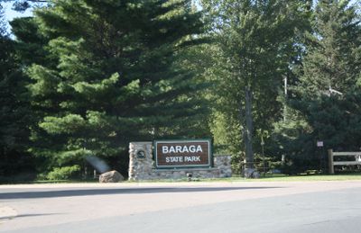
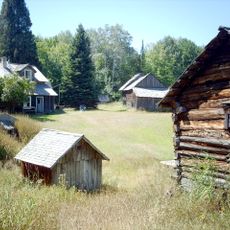
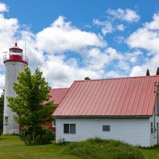
Baraga State Park, Nature reserve and campsite on Keweenaw Bay of Lake Superior, Michigan, US.

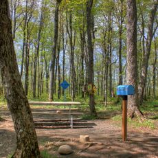
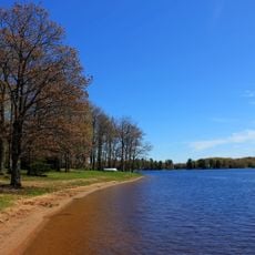
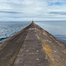
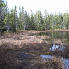
Baraga State Park sits along Lake Superior's shoreline, offering northern forests, hiking routes of varying difficulty, and multiple campground zones. The landscape includes wooded areas that open to water views, with distinct trails connecting different parts of the park.

These lands were long connected to indigenous communities who gathered and hunted along Lake Superior for generations. The establishment as a protected state park opened access to these historically important areas for modern visitors.

This space is managed by Michigan's Department of Natural Resources to keep the Lake Superior shoreline accessible to the public. The park opens up the upper peninsula's natural areas to visitors who want to experience the region on foot and by water.

You need a Recreation Passport to enter the park, and parking is available for both standard vehicles and motorhomes at designated areas. Camping spots are spread across the park with options for tents and RVs, and WiFi is available in certain zones.

Off-road vehicle use is permitted on marked routes between the campground and nearby trails, which connect through to Twin Lakes State Park. This motorized access offers a different way to travel through and experience the landscape.

Location: Baraga

Operator: Michigan Department of Natural Resources

Website: http://shorelinevisitorsguide.com/select-michigan-state-park-maps-and-guides/baraga-state-park

GPS coordinates: 46.76150,-88.50264

Latest update: December 13, 2025 11:45

Photos
Around this place
Mount Arvon
United States of America

Mount Arvon

26.4 km
A. E. Seaman Mineral Museum
United States of America

A. E. Seaman Mineral Museum

39.1 km
Twin Lakes State Park
United States of America

Twin Lakes State Park

30.6 km
United States of America

McCormick Wilderness

39.1 km
United States of America

Sturgeon River Gorge Wilderness

22.8 km
Hebard – Ford Summer House
United States of America

Hebard – Ford Summer House

13.5 km
Keweenaw Waterway Lower Entrance Light
United States of America

Keweenaw Waterway Lower Entrance Light

23.7 km
Herman and Anna Hanka Farm
United States of America

Herman and Anna Hanka Farm

15 km
Memorial Union Building
United States of America

Memorial Union Building

39.9 km
Houghton Fire Hall
United States of America

Houghton Fire Hall

40.4 km
Houghton County Courthouse
United States of America

Houghton County Courthouse

40.3 km
Canyon Falls Bridge
United States of America

Canyon Falls Bridge

15.4 km
Jacobsville Finnish Lutheran Church
United States of America

Jacobsville Finnish Lutheran Church

25.6 km
Ransom B. Shelden House
United States of America

Ransom B. Shelden House

40.2 km
Kaleva Temple
United States of America

Kaleva Temple

36 km
Zeba Indian United Methodist Church
United States of America

Zeba Indian United Methodist Church

6.7 km
Arvon Township Hall
United States of America

Arvon Township Hall

25.1 km
Carnegie Museum of the Keweenaw
United States of America

Carnegie Museum of the Keweenaw

40.4 km
Saint Henry's Evangelical Lutheran Church and Cemetery
United States of America

Saint Henry's Evangelical Lutheran Church and Cemetery

21.5 km
Chassell School Complex
United States of America

Chassell School Complex

30.1 km
Old US 41–Backwater Creek Bridge
United States of America

Old US 41–Backwater Creek Bridge

991 m
County Road C117–Pike River Bridge
United States of America

County Road C117–Pike River Bridge

28.7 km
Robert T. Brown Nature Sanctuary
United States of America

Robert T. Brown Nature Sanctuary

34.4 km
John J. Michels House
United States of America

John J. Michels House

40.1 km
Most Holy Name of Jesus--Saint Blessed Kateri Tekakwitha Catholic Church
United States of America

Most Holy Name of Jesus--Saint Blessed Kateri Tekakwitha Catholic Church

5.9 km
Rozsa Center for the Performing Arts
United States of America

Rozsa Center for the Performing Arts

39.8 km
Jacobsville Lighthouse
United States of America

Jacobsville Lighthouse

25 km
Advanced Technology Development Complex
United States of America

Advanced Technology Development Complex

39.2 km
Show the full map
Reviews

Visited this place? Tap the stars to rate it and share your experience / photos with the community! Try now! You can cancel it anytime.

« Baraga State Park - Nature reserve and campsite on Keweenaw Bay of Lake Superior, Michigan, US » is provided by Around Us (aroundus.com). Images and texts are derived from Wikimedia project under a Creative Commons license. You are allowed to copy, distribute, and modify copies of this page, under the conditions set by the license, as long as this note is clearly visible.

Discover hidden gems everywhere you go!

From secret cafés to breathtaking viewpoints, skip the crowded tourist spots and find places that match your style. Our app makes it easy with voice search, smart filtering, route optimization, and insider tips from travelers worldwide. Download now for the complete mobile experience.

Around Us App Screenshot

A unique approach to discovering new places

Le Figaro

All the places worth exploring

France Info

A tailor-made excursion in just a few clicks

20 Minutes