Log in to your account

AroundUs is a community-driven map of interesting places, built by curious explorers like you. It grows with every review, story, and photo you share.
Connect to save your favorite spots, contribute locations, and create personalized routes.
Continue with Google
Continue with Apple
Continue with X
Continue with Facebook
Continue with email
By continuing, you accept our Terms and Conditions and our Privacy Policy
Create an account

Blue Rock State Forest

Add to collection
Map
Suggest a change
Share

Blue Rock State Forest, State forest in Muskingum County, Ohio, United States.

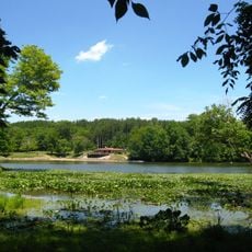
Blue Rock State Forest is a protected woodland area in Muskingum County spanning more than 4,500 acres of natural habitat with gently rolling terrain. An extensive network of trails winds through the forest, allowing visitors to explore diverse forest types and landscape features.

The land was acquired by the federal government during the 1930s as marginally productive farmland through the Resettlement Administration program and later transferred to Ohio's state management. Since then it has been systematically restored to forest and continues to be managed as a natural area.

The forest represents Ohio's commitment to restoring degraded lands, transforming former agricultural areas into natural habitats through systematic replanting efforts. Visitors can observe this recovery as they walk through different sections of the woods.

The forest is easily accessible via State Route 60 and Cutler Lake Road, with Cambridge, Zanesville, and Newark nearby for lodging and supplies. Seasonal conditions significantly affect trail usage, so visitors should come prepared with appropriate gear based on the time of year.

Although now fully managed as a natural area, the federal government retains three-quarters interest in the oil and gas rights beneath the forest. This hidden dual use illustrates the complex reality of how some American forests are managed today.

Location: Ohio

Elevation above the sea: 293 m

GPS coordinates: 39.84100,-81.85800

Latest update: December 14, 2025 16:47

Photos
Around this place
Big Muskie
United States of America

Big Muskie

19.2 km
The Wilds
United States of America

The Wilds

10.8 km
Y-Bridge
United States of America

Y-Bridge

17.3 km
Blue Rock State Park
United States of America

Blue Rock State Park

3 km
John and Annie Glenn Museum
United States of America

John and Annie Glenn Museum

19.9 km
St. Thomas Aquinas Church
United States of America

St. Thomas Aquinas Church

17 km
Masonic Temple Building
United States of America

Masonic Temple Building

16.9 km
Muskingum County Courthouse
United States of America

Muskingum County Courthouse

16.9 km
Helmick Mill Covered Bridge
United States of America

Helmick Mill Covered Bridge

15.3 km
William Rainey Harper Log House
United States of America

William Rainey Harper Log House

20 km
United States Post Office and Federal Building
United States of America

United States Post Office and Federal Building

16.8 km
St. James Episcopal Church
United States of America

St. James Episcopal Church

17 km
St. John's Evangelical Lutheran Church
United States of America

St. John's Evangelical Lutheran Church

11.1 km
Alameda Apartments
United States of America

Alameda Apartments

16.9 km
S Bridge II
United States of America

S Bridge II

19.4 km
Zanesville YWCA
United States of America

Zanesville YWCA

16.8 km
James Boggs Tannehill House
United States of America

James Boggs Tannehill House

18.8 km
St. John's Lutheran Church
United States of America

St. John's Lutheran Church

16.8 km
Salt Creek Covered Bridge
United States of America

Salt Creek Covered Bridge

17.6 km
Adena Court Apartments
United States of America

Adena Court Apartments

16.9 km
West View
United States of America

West View

18.7 km
Ralph Hardesty Stone House
United States of America

Ralph Hardesty Stone House

17.1 km
William B. Harris House
United States of America

William B. Harris House

15.8 km
St. Nicholas' Catholic Church
United States of America

St. Nicholas' Catholic Church

16.5 km
Lafayette Lodge No. 79
United States of America

Lafayette Lodge No. 79

17 km
National Road & Zane Grey Museum
United States of America

National Road & Zane Grey Museum

15.2 km
Mound House
United States of America

Mound House

6.3 km
Y-Bridge
United States of America

Y-Bridge

17.4 km
Show the full map
Reviews

Visited this place? Tap the stars to rate it and share your experience / photos with the community! Try now! You can cancel it anytime.

« Blue Rock State Forest - State forest in Muskingum County, Ohio, United States » is provided by Around Us (aroundus.com). Images and texts are derived from Wikimedia project under a Creative Commons license. You are allowed to copy, distribute, and modify copies of this page, under the conditions set by the license, as long as this note is clearly visible.

Discover hidden gems everywhere you go!

From secret cafés to breathtaking viewpoints, skip the crowded tourist spots and find places that match your style. Our app makes it easy with voice search, smart filtering, route optimization, and insider tips from travelers worldwide. Download now for the complete mobile experience.

Around Us App Screenshot

A unique approach to discovering new places

Le Figaro

All the places worth exploring

France Info

A tailor-made excursion in just a few clicks

20 Minutes