Enable Location

We need your location to show you interesting places around you

Discover nearby places

Find interesting locations and hidden gems around you

Precise directions

Get accurate directions and distances to places

Your location is never shared with other users. It's only used when you tap the location button.

Bennies Hill Road Bridge

Log in to your account

Join the adventure

Create your free account and start exploring (like 60k+ others)

We will send you a code to connect

or
Continue with Google
Continue with Apple
By continuing, you accept our Terms and Conditions and our Privacy Policy

Check your inbox

We've sent a pincode in your inbox. Please enter the code below.

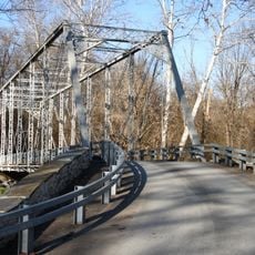
Bennies Hill Road Bridge, Historic road bridge in Middletown, Maryland.

Description

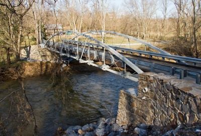
The Bennies Hill Road Bridge is a road bridge in Middletown, Maryland that crosses Catoctin Creek using a steel bowstring arch design from the late 1800s. The curved arch beneath the roadway is characteristic of the structural methods engineers used during that period.

History

The King Bridge Company built this iron structure in 1889 to serve the Frederick County community as a key transportation link. It was constructed during an era when metal bridges were being installed across American rural areas to improve regional connectivity.

Culture

The bridge represents a period of American industrial growth when iron bridges revolutionized transportation infrastructure across rural communities.

Practical

The bridge sits south of Middletown and is accessible by local roads that still handle regular traffic from the area. Visitors should expect the hilly terrain typical of this part of Maryland, with farmland and forest surrounding the crossing.

Did you know?

This bridge is among the few remaining steel bowstring arch spans in Maryland still sitting in their original locations. Such structures were uncommon to build, and it is even rarer for them to stay in place for more than a century without major relocation.

Location
Architects
King Bridge Company
GPS coordinates
39.40940,-77.57000
Latest update
December 14, 2025 18:12

AroundUs brings together thousands of curated places, local tips, and hidden gems, enriched daily by 60,000 contributors worldwide. Discover all places nearby (Maryland).

Around this place
South Mountain
United States of America

South Mountain

11.1 km
Washington Monument State Park
United States of America

Washington Monument State Park

11.1 km
Gathland State Park
United States of America

Gathland State Park

6.1 km
Gambrill State Park
United States of America

Gambrill State Park

9.8 km
National War Correspondents Memorial
United States of America

National War Correspondents Memorial

6 km
Lambs Knoll
United States of America

Lambs Knoll

6.5 km
Dahlgren Chapel
United States of America

Dahlgren Chapel

9.4 km
Brunswick Historic District
United States of America

Brunswick Historic District

11.9 km
Way Off Broadway Dinner Theatre
United States of America

Way Off Broadway Dinner Theatre

10.3 km
Turner's and Fox's Gaps Historic District
United States of America

Turner's and Fox's Gaps Historic District

9.4 km
Middletown Historic District
United States of America

Middletown Historic District

4.5 km
Airview Historic District
United States of America

Airview Historic District

4.9 km
Highland Lodge
United States of America

Highland Lodge

8.2 km
Poffenberger Road Bridge
United States of America

Poffenberger Road Bridge

3.1 km
Henry Shoemaker Farmhouse
United States of America

Henry Shoemaker Farmhouse

6.9 km
George Willard House
United States of America

George Willard House

5.6 km
Crampton's Gap Historic District
United States of America

Crampton's Gap Historic District

6 km
Bowlus Mill House
United States of America

Bowlus Mill House

5.2 km
Washington Monument
United States of America

Washington Monument

11.1 km
Burkittsville Historic District
United States of America

Burkittsville Historic District

5.3 km
Shafer's Mill
United States of America

Shafer's Mill

470 m
Routzahn-Miller Farmstead
United States of America

Routzahn-Miller Farmstead

8.7 km
Rich Mountain
United States of America

Rich Mountain

5.7 km
George Widrick House
United States of America

George Widrick House

10.6 km
Stonebraker and Harbaugh–Shafer Building
United States of America

Stonebraker and Harbaugh–Shafer Building

4.3 km
Reno Monument
United States of America

Reno Monument

7.9 km
Brunswick Heritage Museum
United States of America

Brunswick Heritage Museum

11.8 km
Linden Grove
United States of America

Linden Grove

11.8 km
Show the full map
« Bennies Hill Road Bridge - Historic road bridge in Middletown, Maryland » is provided by Around Us (aroundus.com). Images and texts are derived from Wikimedia project under a Creative Commons license. You are allowed to copy, distribute, and modify copies of this page, under the conditions set by the license, as long as this note is clearly visible.

Discover hidden gems everywhere you go!

From secret cafés to breathtaking viewpoints, skip the crowded tourist spots and find places that match your style. Our app makes it easy with voice search, smart filtering, route optimization, and insider tips from travelers worldwide. Download now for the complete mobile experience.

Around Us App Screenshot

A unique approach to discovering new places

Le Figaro

All the places worth exploring

France Info

A tailor-made excursion in just a few clicks

20 Minutes

Around Us
Travel Guide & Maps
Download

Send to your phone

QR Code
1

Open the camera app on your mobile.

2

Point at the QR code with your camera. A notification will appear.

3

Tap the notification to open the link.