Chest opened
+${chestReward.xp} XP
Explorer
NOUVEAU ×${chestReward.collectible.quantity}
tapez pour fermer
Chest locked

Open chests in the app

Around Us is built for your phone — chests unlock when you walk, explore and capture nearby places.

Enable Location

We need your location to show you interesting places around you

Discover nearby places

Find interesting locations and hidden gems around you

Precise directions

Get accurate directions and distances to places

Your location is never shared with other users. It's only used when you tap the location button.

Log in to your account

Start exploring — it's free

Trusted by 72,890 travelers worldwide

Continue with Google
Continue with Apple
or

We will send you a code to connect

By continuing, you accept our Terms and Conditions and our Privacy Policy

Check your inbox

We've sent a pincode in your inbox. Please enter the code below.

Browns Island
Discussion Reviews Photo
1.8k Popularity

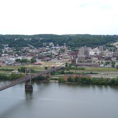
Browns Island, River island in Weirton, West Virginia, United States

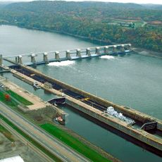
Browns Island is a river island in the Ohio River near Weirton that spans several miles in length and features both industrial development and wooded sections. The landscape combines built-up areas with natural vegetation along the waterway.

The island was documented in the 1700s when George Washington traveled through the area and recorded its location. It later took its name from Richard Brown, a Revolutionary War veteran, who received the land through a grant.

The island contains an ancient Indian burial ground and the Browns Island Petroglyph, which now lies submerged beneath the waters of the Ohio River.

The island is surrounded by water and can only be reached by boat, requiring boat access or river travel. Visitors should know that many areas are privately held and access may be restricted.

Before modern settlement, the island held spiritual meaning for Native peoples who buried their ancestors there in what is now a submerged site. The waters of the river now cover remains of this ancient past.

The community of curious travelers

AroundUs brings together thousands of curated places, local tips, and hidden gems, enriched daily by 60,000 contributors worldwide.

Start exploring
Location
Elevation above the sea
207 m
GPS coordinates
40.42511,-80.60919
Latest update
December 21, 2025 16:05
Around this place
Steubenville
United States of America

Steubenville

6.9 km
Veterans Memorial Bridge
United States of America

Veterans Memorial Bridge

5.3 km
Fort Steuben
United States of America

Fort Steuben

7.5 km
Tomlinson Run State Park
United States of America

Tomlinson Run State Park

13.8 km
Fort Steuben Bridge
United States of America

Fort Steuben Bridge

5.1 km
Market Street Bridge
United States of America

Market Street Bridge

7.5 km
Holy Name Cathedral
United States of America

Holy Name Cathedral

7.8 km
Vancroft
United States of America

Vancroft

16.3 km
Union Cemetery-Beatty Park
United States of America

Union Cemetery-Beatty Park

6.6 km
New Cumberland Locks and Dam
United States of America

New Cumberland Locks and Dam

11.6 km
Devil's Den, McClurg Covered Bridge
United States of America

Devil's Den, McClurg Covered Bridge

8.7 km
Jefferson County Courthouse
United States of America

Jefferson County Courthouse

7.3 km
Wabash Bridge
United States of America

Wabash Bridge

12.8 km
People's Bank
United States of America

People's Bank

3.4 km
Schiappa Branch Library
United States of America

Schiappa Branch Library

8.2 km
Dr. George Rigas House
United States of America

Dr. George Rigas House

2.8 km
Federal Land Office
United States of America

Federal Land Office

7.5 km
Johnston-Truax House
United States of America

Johnston-Truax House

4.8 km
Elmhurst
United States of America

Elmhurst

16.2 km
Ralston Freeman Covered Bridge
United States of America

Ralston Freeman Covered Bridge

9 km
Jackson's Mill Covered Bridge
United States of America

Jackson's Mill Covered Bridge

10.2 km
First National Bank
United States of America

First National Bank

8.1 km
Wellsburg Historic District
United States of America

Wellsburg Historic District

16.3 km
David and Lucy Tarr Fleming Mansion
United States of America

David and Lucy Tarr Fleming Mansion

15.9 km
John C. Reeves House
United States of America

John C. Reeves House

14.9 km
Toronto World War I Monument
United States of America

Toronto World War I Monument

4.6 km
Marshall House
United States of America

Marshall House

7.9 km
Kirker House
United States of America

Kirker House

16.3 km
Show the full map
Reviews
Share your experience

No review yet

Discussions
Start a discussion...

No discussion yet

« Browns Island - River island in Weirton, West Virginia, United States » is provided by Around Us (aroundus.com). Images and texts are derived from Wikimedia project under a Creative Commons license. You are allowed to copy, distribute, and modify copies of this page, under the conditions set by the license, as long as this note is clearly visible.

Discover hidden gems everywhere you go!

From secret cafés to breathtaking viewpoints, skip the crowded tourist spots and find places that match your style. Our app makes it easy with voice search, smart filtering, route optimization, and insider tips from travelers worldwide. Download now for the complete mobile experience.

Around Us App Screenshot

A unique approach to discovering new places

Le Figaro

All the places worth exploring

France Info

A tailor-made excursion in just a few clicks

20 Minutes

Around Us
Travel Guide & Maps
Download

Send to your phone

QR Code
1

Open the camera app on your mobile.

2

Point at the QR code with your camera. A notification will appear.

3

Tap the notification to open the link.