Devil's Den, McClurg Covered Bridge

Log in to your account

AroundUs is a community-driven map of interesting places, built by curious explorers like you. It grows with every review, story, and photo you share.
Connect to save your favorite spots, contribute locations, and create personalized routes.
Continue with Google
Continue with Apple
Continue with X
Continue with Facebook
Continue with email
By continuing, you accept our Terms and Conditions and our Privacy Policy
Create an account
Add to collection
Map
Suggest a change
Share

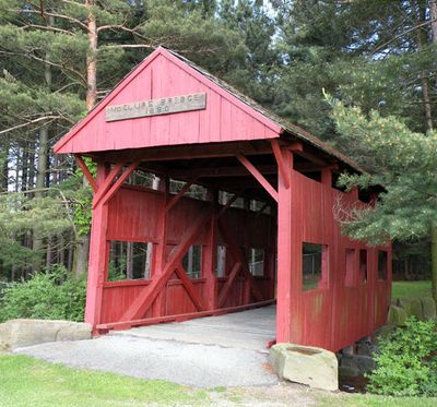
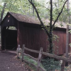
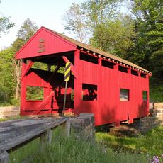
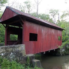
Devil's Den, McClurg Covered Bridge, Covered bridge in Hanover Township, Pennsylvania, US

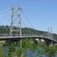
The Devil's Den McClurg Covered Bridge is a wooden structure that crosses a local waterway with a traditional kingpost truss design. The bridge features the characteristic covered wooden framework built using construction methods common in the late 1800s.

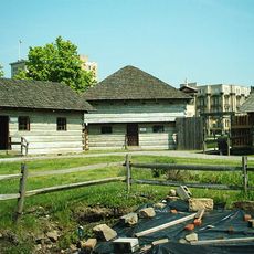
This structure was built in 1880 as part of the rural transportation network that connected communities across Pennsylvania. Its recognition on the National Register of Historic Places marks its importance to the region's development during that era.

The bridge once linked nearby farms and villages, serving as a gathering point where neighbors met and news traveled. Today, its presence still marks the importance of local connections in rural Pennsylvania life.

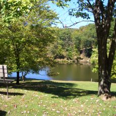
The bridge can be crossed on foot, allowing visitors to observe the woodwork and construction details up close while exploring the surrounding area. The paths are easiest to navigate during drier months when ground conditions are better.

The name comes from a local legend that circulated in the area long before the bridge was built. This tie to regional folklore gives the structure a meaning that goes beyond its role as a simple crossing.

Location: Pennsylvania

GPS coordinates: 40.42472,-80.50667

Latest update: December 14, 2025 14:22

Photos
Around this place
Steubenville
United States of America

Steubenville

12.5 km
Raccoon Creek State Park
United States of America

Raccoon Creek State Park

11.1 km
Veterans Memorial Bridge
United States of America

Veterans Memorial Bridge

10.3 km
Fort Steuben
United States of America

Fort Steuben

11.7 km
Tomlinson Run State Park
United States of America

Tomlinson Run State Park

15.3 km
Fort Steuben Bridge
United States of America

Fort Steuben Bridge

10.3 km
Hillman State Park
United States of America

Hillman State Park

11.9 km
Market Street Bridge
United States of America

Market Street Bridge

11.4 km
Holy Name Cathedral
United States of America

Holy Name Cathedral

12.3 km
Union Cemetery-Beatty Park
United States of America

Union Cemetery-Beatty Park

12.4 km
New Cumberland Locks and Dam
United States of America

New Cumberland Locks and Dam

15.3 km
Jefferson County Courthouse
United States of America

Jefferson County Courthouse

11.6 km
Wabash Bridge
United States of America

Wabash Bridge

15.1 km
People's Bank
United States of America

People's Bank

7.1 km
Schiappa Branch Library
United States of America

Schiappa Branch Library

15.4 km
Pine Bank Covered Bridge
United States of America

Pine Bank Covered Bridge

15.2 km
Dr. George Rigas House
United States of America

Dr. George Rigas House

7.5 km
Federal Land Office
United States of America

Federal Land Office

11.8 km
Lyle Covered Bridge
United States of America

Lyle Covered Bridge

11.6 km
Johnston-Truax House
United States of America

Johnston-Truax House

4 km
Ralston Freeman Covered Bridge
United States of America

Ralston Freeman Covered Bridge

2.5 km
Jackson's Mill Covered Bridge
United States of America

Jackson's Mill Covered Bridge

1.5 km
First National Bank
United States of America

First National Bank

12 km
John C. Reeves House
United States of America

John C. Reeves House

15.2 km
Toronto World War I Monument
United States of America

Toronto World War I Monument

9.1 km
Raccoon Creek State Park Historic District
United States of America

Raccoon Creek State Park Historic District

10.8 km
Marshall House
United States of America

Marshall House

11.5 km
Federal Land Office
United States of America

Federal Land Office

11.7 km
Show the full map
Reviews

Visited this place? Tap the stars to rate it and share your experience / photos with the community! Try now! You can cancel it anytime.

« Devil's Den, McClurg Covered Bridge - Covered bridge in Hanover Township, Pennsylvania, US » is provided by Around Us (aroundus.com). Images and texts are derived from Wikimedia project under a Creative Commons license. You are allowed to copy, distribute, and modify copies of this page, under the conditions set by the license, as long as this note is clearly visible.

Discover hidden gems everywhere you go!

From secret cafés to breathtaking viewpoints, skip the crowded tourist spots and find places that match your style. Our app makes it easy with voice search, smart filtering, route optimization, and insider tips from travelers worldwide. Download now for the complete mobile experience.

Around Us App Screenshot

A unique approach to discovering new places

Le Figaro

All the places worth exploring

France Info

A tailor-made excursion in just a few clicks

20 Minutes