Enable Location

We need your location to show you interesting places around you

Discover nearby places

Find interesting locations and hidden gems around you

Precise directions

Get accurate directions and distances to places

Your location is never shared with other users. It's only used when you tap the location button.

Charleroi Locks & Dam

Log in to your account

Start exploring — it's free

Trusted by 62,838 travelers worldwide

Continue with Google
Continue with Apple
or

We will send you a code to connect

By continuing, you accept our Terms and Conditions and our Privacy Policy

Check your inbox

We've sent a pincode in your inbox. Please enter the code below.

Charleroi Locks & Dam

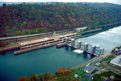
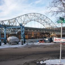
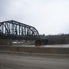
Charleroi Locks & Dam, dam in Charleroi, Pennsylvania and Monessen, Pennsylvania

The Charleroi Locks & Dam is a water management structure on the Monongahela River in Westmoreland County that allows boats to pass between different water levels. Heavy metal gates and concrete chambers work together with a gravity dam to move vessels and maintain steady flow conditions.

The locks and dam were built many decades ago to enable river shipping and support local commerce. Recently, a new lock chamber was constructed to handle more vessels at once and improve the river's capacity for freight transport.

The name "Charleroi" derives from French origins, echoing a city of the same name in Belgium. Workers and locals view this structure as central to their community's identity and its long relationship with river commerce.

The site is visible from nearby roads and offers vantage points for watching boats move through the lock system. Visitors should expect active work areas, occasional machinery noise, and varying water levels depending on vessel traffic at different times of day.

During recent maintenance work, enough water was pumped from the lock chamber to fill 30 Olympic-sized swimming pools, marking a major milestone in preparing the facility for upgrades. This enormous volume demonstrates the scale of engineering required to manage river operations.

The community of curious travelers

AroundUs brings together thousands of curated places, local tips, and hidden gems, enriched daily by 60,000 contributors worldwide.

Start exploring
GPS coordinates
40.14620,-79.90000
Latest update
February 9, 2026 11:06
Around this place
Youghiogheny River Trail
United States of America

Youghiogheny River Trail

12.1 km
Cement City Historic District
United States of America

Cement City Historic District

4 km
United States of America

Round Hill Park

12.2 km
Donora-Monessen Bridge
United States of America

Donora-Monessen Bridge

3.7 km
Edward G. Acheson House
United States of America

Edward G. Acheson House

7.2 km
Donora-Webster Bridge
United States of America

Donora-Webster Bridge

5.9 km
Belle Vernon Bridge
United States of America

Belle Vernon Bridge

2.8 km
Henry Covered Bridge
United States of America

Henry Covered Bridge

11.7 km
Van Kirk Farm
United States of America

Van Kirk Farm

11 km
Speers Railroad Bridge
United States of America

Speers Railroad Bridge

2.7 km
Old Main
United States of America

Old Main

9 km
Charleroi-Monessen Bridge
United States of America

Charleroi-Monessen Bridge

704 m
Molly Fleming House
United States of America

Molly Fleming House

9.4 km
California Area Public Library
United States of America

California Area Public Library

8.7 km
David Longwell House
United States of America

David Longwell House

7.1 km
Charleroi Historic District
United States of America

Charleroi Historic District

561 m
Col. Edward Cook House
United States of America

Col. Edward Cook House

6.6 km
Jennings-Gallagher House
United States of America

Jennings-Gallagher House

9.1 km
Hutchinson Farm (Elizabeth, Pennsylvania)
United States of America

Hutchinson Farm (Elizabeth, Pennsylvania)

10.8 km
West Brownsville Junction Bridge
United States of America

West Brownsville Junction Bridge

12.7 km
Bethel African American Episcopal Church of Monongahela City
United States of America

Bethel African American Episcopal Church of Monongahela City

7.3 km
Cerl Wright Covered Bridge
United States of America

Cerl Wright Covered Bridge

12.7 km
Harrison House
United States of America

Harrison House

12.8 km
Matthew Smelser Memorial Bridge
United States of America

Matthew Smelser Memorial Bridge

12.1 km
First National Bank of Charleroi
United States of America

First National Bank of Charleroi

907 m
Whitsett Historic District
United States of America

Whitsett Historic District

11.7 km
Arboreto de la universidad de California en Pensilvania
United States of America

Arboreto de la universidad de California en Pensilvania

8.9 km
Hepner–Bailey Field at Adamson Stadium
United States of America

Hepner–Bailey Field at Adamson Stadium

10.8 km
Show the full map
« Charleroi Locks & Dam - dam in Charleroi, Pennsylvania and Monessen, Pennsylvania » is provided by Around Us (aroundus.com). Images and texts are derived from Wikimedia project under a Creative Commons license. You are allowed to copy, distribute, and modify copies of this page, under the conditions set by the license, as long as this note is clearly visible.

Discover hidden gems everywhere you go!

From secret cafés to breathtaking viewpoints, skip the crowded tourist spots and find places that match your style. Our app makes it easy with voice search, smart filtering, route optimization, and insider tips from travelers worldwide. Download now for the complete mobile experience.

Around Us App Screenshot

A unique approach to discovering new places

Le Figaro

All the places worth exploring

France Info

A tailor-made excursion in just a few clicks

20 Minutes

Around Us
Travel Guide & Maps
Download

Send to your phone

QR Code
1

Open the camera app on your mobile.

2

Point at the QR code with your camera. A notification will appear.

3

Tap the notification to open the link.