Enable Location

We need your location to show you interesting places around you

Discover nearby places

Find interesting locations and hidden gems around you

Precise directions

Get accurate directions and distances to places

Your location is never shared with other users. It's only used when you tap the location button.

Donora-Webster Bridge

Log in to your account

Start exploring — it's free

Trusted by 62,248 travelers worldwide

Continue with Google
Continue with Apple
or

We will send you a code to connect

By continuing, you accept our Terms and Conditions and our Privacy Policy

Check your inbox

We've sent a pincode in your inbox. Please enter the code below.

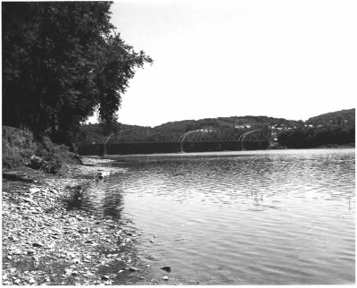
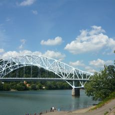
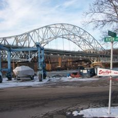
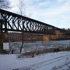
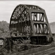
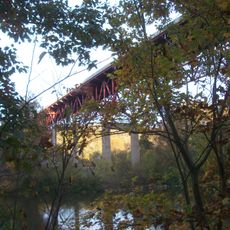
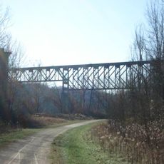
Donora-Webster Bridge, Railway bridge across Monongahela River in Donora, US.

The Donora-Webster Bridge was a steel truss structure spanning the Monongahela River between Donora Borough and Webster, serving vehicle traffic across the waterway. The bridge connected road networks on both banks that linked these two communities.

The structure was built in 1908 originally for railroad traffic, then redesigned in 1938 to support automobile crossing as well. This conversion made it a key route for vehicle movement between the two communities.

The bridge gained recognition on the National Register of Historic Places in 1988 for its engineering design and role in regional transportation development.

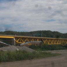
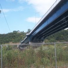
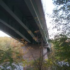
The bridge was open to public vehicle traffic beginning in 1938 and provided a direct crossing between both communities. The structure no longer stands today after being demolished in 2015.

The bridge's removal was a complex operation involving the extraction of over 700 tons of steel while railroad lines beneath remained active. Special protective systems underneath the structure helped safeguard the active rail operations during demolition.

The community of curious travelers

AroundUs brings together thousands of curated places, local tips, and hidden gems, enriched daily by 60,000 contributors worldwide.

Start exploring
Location
Location
Official opening
1908
GPS coordinates
40.18417,-79.85222
Latest update
December 14, 2025 14:25
Around this place
Youghiogheny River Trail
United States of America

Youghiogheny River Trail

8.3 km
Cement City Historic District
United States of America

Cement City Historic District

1.9 km
United States of America

Round Hill Park

6.9 km
Donora-Monessen Bridge
United States of America

Donora-Monessen Bridge

2.5 km
Edward G. Acheson House
United States of America

Edward G. Acheson House

7.3 km
Regis R. Malady Bridge
United States of America

Regis R. Malady Bridge

10.6 km
Belle Vernon Bridge
United States of America

Belle Vernon Bridge

6.7 km
Van Kirk Farm
United States of America

Van Kirk Farm

6.4 km
Elizabeth Locks & Dam
United States of America

Elizabeth Locks & Dam

9.9 km
Speers Railroad Bridge
United States of America

Speers Railroad Bridge

6.7 km
Union Railroad Clairton Bridge
United States of America

Union Railroad Clairton Bridge

12.3 km
Charleroi-Monessen Bridge
United States of America

Charleroi-Monessen Bridge

5.7 km
Charleroi Locks & Dam
United States of America

Charleroi Locks & Dam

5.9 km
West Newton Bridge
United States of America

West Newton Bridge

7.7 km
David Longwell House
United States of America

David Longwell House

7.1 km
Charleroi Historic District
United States of America

Charleroi Historic District

6.4 km
Dick Building
United States of America

Dick Building

7.8 km
Col. Edward Cook House
United States of America

Col. Edward Cook House

6.7 km
Hutchinson Farm (Elizabeth, Pennsylvania)
United States of America

Hutchinson Farm (Elizabeth, Pennsylvania)

6.3 km
Plumer House
United States of America

Plumer House

7.6 km
Bethel African American Episcopal Church of Monongahela City
United States of America

Bethel African American Episcopal Church of Monongahela City

7.2 km
Dusmal House
United States of America

Dusmal House

12.3 km
Matthew Smelser Memorial Bridge
United States of America

Matthew Smelser Memorial Bridge

8.3 km
First National Bank of Charleroi
United States of America

First National Bank of Charleroi

6.4 km
Banning Railroad Bridge
United States of America

Banning Railroad Bridge

11.1 km
Whitsett Historic District
United States of America

Whitsett Historic District

11 km
Smithton Low-Level Bridge
United States of America

Smithton Low-Level Bridge

9.6 km
John H. Nelson House
United States of America

John H. Nelson House

10.5 km
Show the full map
« Donora-Webster Bridge - Railway bridge across Monongahela River in Donora, US » is provided by Around Us (aroundus.com). Images and texts are derived from Wikimedia project under a Creative Commons license. You are allowed to copy, distribute, and modify copies of this page, under the conditions set by the license, as long as this note is clearly visible.

Discover hidden gems everywhere you go!

From secret cafés to breathtaking viewpoints, skip the crowded tourist spots and find places that match your style. Our app makes it easy with voice search, smart filtering, route optimization, and insider tips from travelers worldwide. Download now for the complete mobile experience.

Around Us App Screenshot

A unique approach to discovering new places

Le Figaro

All the places worth exploring

France Info

A tailor-made excursion in just a few clicks

20 Minutes

Around Us
Travel Guide & Maps
Download

Send to your phone

QR Code
1

Open the camera app on your mobile.

2

Point at the QR code with your camera. A notification will appear.

3

Tap the notification to open the link.