Enable Location

We need your location to show you interesting places around you

Discover nearby places

Find interesting locations and hidden gems around you

Precise directions

Get accurate directions and distances to places

Your location is never shared with other users. It's only used when you tap the location button.

Union Railroad Clairton Bridge

Log in to your account

Start exploring — it's free

Trusted by 62,430 travelers worldwide

Continue with Google
Continue with Apple
or

We will send you a code to connect

By continuing, you accept our Terms and Conditions and our Privacy Policy

Check your inbox

We've sent a pincode in your inbox. Please enter the code below.

Union Railroad Clairton Bridge

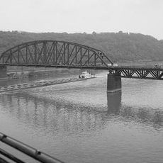
Union Railroad Clairton Bridge, bridge in Allegheny County, Pennsylvania

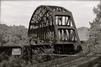
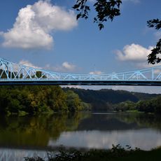
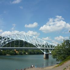
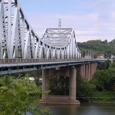
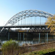
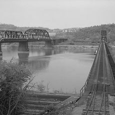
The Union Railroad Clairton Bridge is a steel truss structure that crosses the Monongahela River in Pennsylvania, spanning between two settlements. The main span stretches approximately 480 feet (146 meters), and the framework consists of interconnected metal beams arranged in triangular patterns that distributed train loads across the structure.

Built in 1893, the bridge was part of the railroad network that transported raw materials and finished products for the steel industry across the Monongahela River. By the 1970s, train traffic ceased as operations shifted to other facilities nearby, yet the structure has remained standing as a witness to the region's industrial past.

The bridge carries the name of nearby Clairton and stands as a reminder of when railroads shaped life in this region. It reflects the working-class roots of the area and how transportation routes connected factories and communities.

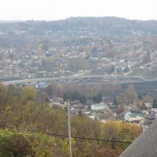
The site is accessible from the Clairton area, with viewpoints where you can see the structure spanning the river. You can approach the bridge on foot and get close enough to observe the metal framework details, particularly during daylight hours when the structure is most visible.

The bridge was designed with the potential to add an upper deck for additional tracks in the future, but this expansion never happened. This foresight in engineering shows how planners anticipated growth that ultimately did not materialize.

The community of curious travelers

AroundUs brings together thousands of curated places, local tips, and hidden gems, enriched daily by 60,000 contributors worldwide.

Start exploring
Location
Official opening
1893
GPS coordinates
40.29450,-79.86690
Latest update
February 9, 2026 07:44
Around this place
Kennywood
United States of America

Kennywood

10.4 km
Steel Curtain
United States of America

Steel Curtain

10.3 km
Phantom's Revenge
United States of America

Phantom's Revenge

10.5 km
Thunderbolt
United States of America

Thunderbolt

10.5 km
Jack Rabbit
United States of America

Jack Rabbit

10.3 km
Sky Rocket
United States of America

Sky Rocket

10.2 km
Racer
United States of America

Racer

10.3 km
United States of America

Round Hill Park

5.9 km
Boston Bridge
United States of America

Boston Bridge

3.9 km
St. Mary's Church, McKeesport
United States of America

St. Mary's Church, McKeesport

6 km
Regis R. Malady Bridge
United States of America

Regis R. Malady Bridge

2.8 km
W.D. Mansfield Memorial Bridge
United States of America

W.D. Mansfield Memorial Bridge

5.9 km
Clairton-Glassport Bridge
United States of America

Clairton-Glassport Bridge

2.7 km
Jerome Street Bridge
United States of America

Jerome Street Bridge

6.2 km
Van Kirk Farm
United States of America

Van Kirk Farm

6 km
Elizabeth Locks & Dam
United States of America

Elizabeth Locks & Dam

4.3 km
McKeesport Connecting Railroad Bridge
United States of America

McKeesport Connecting Railroad Bridge

7.1 km
McKeesport-Duquesne Bridge
United States of America

McKeesport-Duquesne Bridge

7.3 km
Carnegie Free Library
United States of America

Carnegie Free Library

5.7 km
PRR Port Perry Bridge
United States of America

PRR Port Perry Bridge

10.4 km
McKeesport National Bank
United States of America

McKeesport National Bank

6.3 km
First Methodist Episcopal Church of McKeesport
United States of America

First Methodist Episcopal Church of McKeesport

5.8 km
Hutchinson Farm (Elizabeth, Pennsylvania)
United States of America

Hutchinson Farm (Elizabeth, Pennsylvania)

6.1 km
Bridge in Jefferson Borough
United States of America

Bridge in Jefferson Borough

8.8 km
Dusmal House
United States of America

Dusmal House

9.6 km
Bowman Homestead
United States of America

Bowman Homestead

9.2 km
Jefferson Hills Public Library
United States of America

Jefferson Hills Public Library

5.3 km
Union Railroad Port Perry Bridge
United States of America

Union Railroad Port Perry Bridge

10.5 km
Show the full map
« Union Railroad Clairton Bridge - bridge in Allegheny County, Pennsylvania » is provided by Around Us (aroundus.com). Images and texts are derived from Wikimedia project under a Creative Commons license. You are allowed to copy, distribute, and modify copies of this page, under the conditions set by the license, as long as this note is clearly visible.

Discover hidden gems everywhere you go!

From secret cafés to breathtaking viewpoints, skip the crowded tourist spots and find places that match your style. Our app makes it easy with voice search, smart filtering, route optimization, and insider tips from travelers worldwide. Download now for the complete mobile experience.

Around Us App Screenshot

A unique approach to discovering new places

Le Figaro

All the places worth exploring

France Info

A tailor-made excursion in just a few clicks

20 Minutes

Around Us
Travel Guide & Maps
Download

Send to your phone

QR Code
1

Open the camera app on your mobile.

2

Point at the QR code with your camera. A notification will appear.

3

Tap the notification to open the link.