Enable Location

We need your location to show you interesting places around you

Discover nearby places

Find interesting locations and hidden gems around you

Precise directions

Get accurate directions and distances to places

Your location is never shared with other users. It's only used when you tap the location button.

PRR Port Perry Bridge

Log in to your account

Start exploring — it's free

Trusted by 62,441 travelers worldwide

Continue with Google
Continue with Apple
or

We will send you a code to connect

By continuing, you accept our Terms and Conditions and our Privacy Policy

Check your inbox

We've sent a pincode in your inbox. Please enter the code below.

PRR Port Perry Bridge

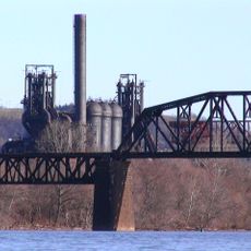
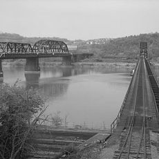
PRR Port Perry Bridge, railroad bridge in Pennsylvania

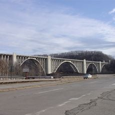
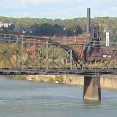
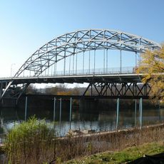
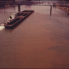
The PRR Port Perry Bridge is a steel truss bridge that crosses the Monongahela River in Allegheny County, connecting North Versailles Township and Duquesne. The structure uses pin-connected truss designs with stone supports, and Norfolk Southern Railway operates it today for freight transport across the region.

The bridge was first constructed in the 1870s and then significantly updated between 1903 and 1904 to handle increased traffic. Further work in the 1930s reinforced the structure to ensure it could serve freight operations reliably for decades to come.

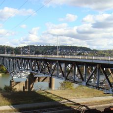
The bridge carries the name of nearby Port Perry and reflects the railroad's importance to this region. Today, visitors see a sturdy steel structure that trains still cross, embodying the industrial heritage that shaped local communities.

Visitors can observe the bridge from the riverbank and photograph the steel framework up close from nearby access points. The best views are from North Versailles Township or Duquesne approaches, and arriving in early morning hours provides ideal light for capturing details of the metal trusses.

The structure combines multiple truss systems such as Parker, Warren, and deck trusses within a single framework, showing how engineers applied different design principles to solve the challenge of crossing the river. This technical diversity makes it a living example of early railroad engineering problem-solving.

The community of curious travelers

AroundUs brings together thousands of curated places, local tips, and hidden gems, enriched daily by 60,000 contributors worldwide.

Start exploring
Location
Official opening
1903
GPS coordinates
40.38710,-79.85130
Latest update
February 9, 2026 07:42
Around this place
Kennywood
United States of America

Kennywood

1 km
Steel Curtain
United States of America

Steel Curtain

808 m
Phantom's Revenge
United States of America

Phantom's Revenge

1.3 km
Carrie Furnace
United States of America

Carrie Furnace

4.4 km
Thunderbolt
United States of America

Thunderbolt

1.2 km
Jack Rabbit
United States of America

Jack Rabbit

976 m
Sky Rocket
United States of America

Sky Rocket

1.1 km
Racer
United States of America

Racer

899 m
Carnegie Library of Homestead
United States of America

Carnegie Library of Homestead

4.9 km
Exterminator
United States of America

Exterminator

1.4 km
George Westinghouse Bridge
United States of America

George Westinghouse Bridge

1.5 km
Carnegie Free Library of Braddock
United States of America

Carnegie Free Library of Braddock

2 km
Westinghouse Air Brake Company General Office Building
United States of America

Westinghouse Air Brake Company General Office Building

3.8 km
Braddock Locks & Dam
United States of America

Braddock Locks & Dam

684 m
Carrie Furnace Hot Metal Bridge
United States of America

Carrie Furnace Hot Metal Bridge

3.8 km
Trundle Manor
United States of America

Trundle Manor

4.7 km
Rankin Bridge
United States of America

Rankin Bridge

3.2 km
St. Mary's Church, McKeesport
United States of America

St. Mary's Church, McKeesport

4.4 km
Jerome Street Bridge
United States of America

Jerome Street Bridge

4.4 km
McKeesport Connecting Railroad Bridge
United States of America

McKeesport Connecting Railroad Bridge

3.4 km
McKeesport-Duquesne Bridge
United States of America

McKeesport-Duquesne Bridge

3.3 km
Carnegie Free Library
United States of America

Carnegie Free Library

4.7 km
McKeesport National Bank
United States of America

McKeesport National Bank

4.1 km
First Methodist Episcopal Church of McKeesport
United States of America

First Methodist Episcopal Church of McKeesport

4.6 km
St. Colman's Catholic School
United States of America

St. Colman's Catholic School

2.9 km
Bowman Homestead
United States of America

Bowman Homestead

2.8 km
Union Railroad Port Perry Bridge
United States of America

Union Railroad Port Perry Bridge

126 m
Grand View Golf Club
United States of America

Grand View Golf Club

1.5 km
Show the full map
« PRR Port Perry Bridge - railroad bridge in Pennsylvania » is provided by Around Us (aroundus.com). Images and texts are derived from Wikimedia project under a Creative Commons license. You are allowed to copy, distribute, and modify copies of this page, under the conditions set by the license, as long as this note is clearly visible.

Discover hidden gems everywhere you go!

From secret cafés to breathtaking viewpoints, skip the crowded tourist spots and find places that match your style. Our app makes it easy with voice search, smart filtering, route optimization, and insider tips from travelers worldwide. Download now for the complete mobile experience.

Around Us App Screenshot

A unique approach to discovering new places

Le Figaro

All the places worth exploring

France Info

A tailor-made excursion in just a few clicks

20 Minutes

Around Us
Travel Guide & Maps
Download

Send to your phone

QR Code
1

Open the camera app on your mobile.

2

Point at the QR code with your camera. A notification will appear.

3

Tap the notification to open the link.