Enable Location

We need your location to show you interesting places around you

Discover nearby places

Find interesting locations and hidden gems around you

Precise directions

Get accurate directions and distances to places

Your location is never shared with other users. It's only used when you tap the location button.

Elizabeth Locks & Dam

Log in to your account

Start exploring — it's free

Trusted by 61,367 travelers worldwide

Continue with Google
Continue with Apple
or

We will send you a code to connect

By continuing, you accept our Terms and Conditions and our Privacy Policy

Check your inbox

We've sent a pincode in your inbox. Please enter the code below.

Elizabeth Locks & Dam

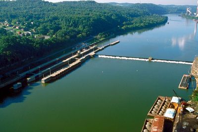
Elizabeth Locks & Dam, Navigation system in Elizabeth, United States.

Description

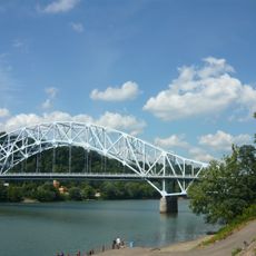
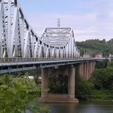
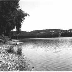
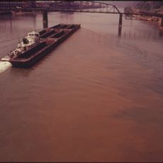
Elizabeth Locks and Dam is a navigation system on the Monongahela River consisting of two lock chambers and a concrete barrier that controls water flow. The structure manages water levels across the river to allow vessels to pass through different elevations.

History

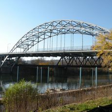
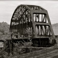
Construction began in 1905 under the U.S. Army Corps of Engineers to improve river traffic. The original structure underwent major changes in the 1920s.

Culture

The locks and dam are part of the industrial heritage of the region, helping workers and industries transport goods by river traffic.

Practical

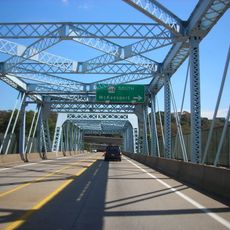
The best view of the facility comes from the riverbank or nearby public areas. When visiting, watch for safety signs and follow any staff directions.

Did you know?

A permanent concrete structure replaced the original steel drum weir in 1921, marking an important engineering advancement. This change provided more durable and reliable water control.

Location
GPS coordinates
40.26500,-79.90000
Latest update
December 14, 2025 17:04

AroundUs brings together thousands of curated places, local tips, and hidden gems, enriched daily by 60,000 contributors worldwide. Discover all places nearby (Allegheny County).

Around this place
Oliver Miller Homestead
United States of America

Oliver Miller Homestead

10.9 km
South Park
United States of America

South Park

10.9 km
Cement City Historic District
United States of America

Cement City Historic District

10.9 km
United States of America

Round Hill Park

5.5 km
Boston Bridge
United States of America

Boston Bridge

8.1 km
St. Mary's Church, McKeesport
United States of America

St. Mary's Church, McKeesport

9.8 km
Donora-Monessen Bridge
United States of America

Donora-Monessen Bridge

11.9 km
Edward G. Acheson House
United States of America

Edward G. Acheson House

7.2 km
Regis R. Malady Bridge
United States of America

Regis R. Malady Bridge

1.5 km
W.D. Mansfield Memorial Bridge
United States of America

W.D. Mansfield Memorial Bridge

9 km
Clairton-Glassport Bridge
United States of America

Clairton-Glassport Bridge

5.5 km
Donora-Webster Bridge
United States of America

Donora-Webster Bridge

9.9 km
Jerome Street Bridge
United States of America

Jerome Street Bridge

9.8 km
Henry Covered Bridge
United States of America

Henry Covered Bridge

12.1 km
Van Kirk Farm
United States of America

Van Kirk Farm

4.2 km
McKeesport Connecting Railroad Bridge
United States of America

McKeesport Connecting Railroad Bridge

11.2 km
McKeesport-Duquesne Bridge
United States of America

McKeesport-Duquesne Bridge

11.4 km
Carnegie Free Library
United States of America

Carnegie Free Library

9.7 km
Union Railroad Clairton Bridge
United States of America

Union Railroad Clairton Bridge

4.3 km
Charleroi-Monessen Bridge
United States of America

Charleroi-Monessen Bridge

12.6 km
McKeesport National Bank
United States of America

McKeesport National Bank

10.1 km
David Longwell House
United States of America

David Longwell House

7.1 km
Enoch Wright House
United States of America

Enoch Wright House

11.1 km
First Methodist Episcopal Church of McKeesport
United States of America

First Methodist Episcopal Church of McKeesport

9.7 km
Hutchinson Farm (Elizabeth, Pennsylvania)
United States of America

Hutchinson Farm (Elizabeth, Pennsylvania)

4.1 km
Bethel African American Episcopal Church of Monongahela City
United States of America

Bethel African American Episcopal Church of Monongahela City

7 km
Bridge in Jefferson Borough
United States of America

Bridge in Jefferson Borough

6.7 km
Dusmal House
United States of America

Dusmal House

5.7 km
Show the full map
« Elizabeth Locks & Dam - Navigation system in Elizabeth, United States » is provided by Around Us (aroundus.com). Images and texts are derived from Wikimedia project under a Creative Commons license. You are allowed to copy, distribute, and modify copies of this page, under the conditions set by the license, as long as this note is clearly visible.

Discover hidden gems everywhere you go!

From secret cafés to breathtaking viewpoints, skip the crowded tourist spots and find places that match your style. Our app makes it easy with voice search, smart filtering, route optimization, and insider tips from travelers worldwide. Download now for the complete mobile experience.

Around Us App Screenshot

A unique approach to discovering new places

Le Figaro

All the places worth exploring

France Info

A tailor-made excursion in just a few clicks

20 Minutes

Around Us
Travel Guide & Maps
Download

Send to your phone

QR Code
1

Open the camera app on your mobile.

2

Point at the QR code with your camera. A notification will appear.

3

Tap the notification to open the link.