Enable Location

We need your location to show you interesting places around you

Discover nearby places

Find interesting locations and hidden gems around you

Precise directions

Get accurate directions and distances to places

Your location is never shared with other users. It's only used when you tap the location button.

Cement City Historic District

Log in to your account

Start exploring — it's free

Trusted by 61,364 travelers worldwide

Continue with Google
Continue with Apple
or

We will send you a code to connect

By continuing, you accept our Terms and Conditions and our Privacy Policy

Check your inbox

We've sent a pincode in your inbox. Please enter the code below.

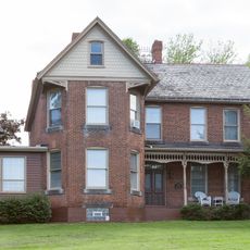
Cement City Historic District, Historic district in Donora, United States.

Description

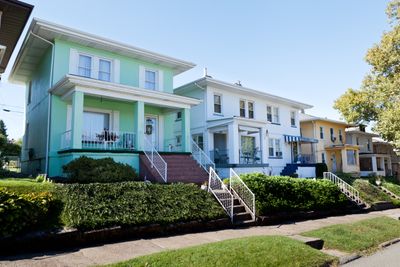
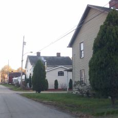
Cement City Historic District is a residential area with approximately 80 concrete homes built in Prairie School style along Chestnut and Walnut Streets. The structures were constructed using a patented concrete method and remain standing as private residences today.

History

The development was commissioned in 1916 by the American Steel and Wire Company as housing for its workers near the factory. A specialized company used its patented concrete construction method to build the entire residential settlement.

Culture

This development grew out of an industrial company's plan to house its factory workers and their families in one unified community. The homes reflect early 20th-century thinking about how employers could shape worker lives through carefully designed neighborhoods.

Practical

The district covers about 8.8 acres between Modisette and Bertha Avenues in a compact area. Since the homes remain private residences, visitors can best explore by walking the surrounding streets to view the architecture from public spaces.

Did you know?

The construction of the entire complex required roughly 10,000 barrels of Portland cement, underscoring the scale of this early concrete building project. This enormous quantity of material made the undertaking a significant technical achievement for its time.

Location
GPS coordinates
40.17083,-79.86556
Latest update
December 12, 2025 09:00

AroundUs brings together thousands of curated places, local tips, and hidden gems, enriched daily by 60,000 contributors worldwide. Discover all places nearby (Donora).

Around this place
Youghiogheny River Trail
United States of America

Youghiogheny River Trail

9.1 km
United States of America

Round Hill Park

8.6 km
Donora-Monessen Bridge
United States of America

Donora-Monessen Bridge

990 m
Edward G. Acheson House
United States of America

Edward G. Acheson House

6.9 km
Regis R. Malady Bridge
United States of America

Regis R. Malady Bridge

11.8 km
Donora-Webster Bridge
United States of America

Donora-Webster Bridge

1.9 km
Belle Vernon Bridge
United States of America

Belle Vernon Bridge

5 km
Van Kirk Farm
United States of America

Van Kirk Farm

7.8 km
Elizabeth Locks & Dam
United States of America

Elizabeth Locks & Dam

10.9 km
Speers Railroad Bridge
United States of America

Speers Railroad Bridge

5 km
Charleroi-Monessen Bridge
United States of America

Charleroi-Monessen Bridge

3.9 km
Charleroi Locks & Dam
United States of America

Charleroi Locks & Dam

4 km
California Area Public Library
United States of America

California Area Public Library

11.6 km
West Newton Bridge
United States of America

West Newton Bridge

9.3 km
David Longwell House
United States of America

David Longwell House

6.8 km
Charleroi Historic District
United States of America

Charleroi Historic District

4.5 km
Dick Building
United States of America

Dick Building

9.5 km
Col. Edward Cook House
United States of America

Col. Edward Cook House

5.9 km
Hutchinson Farm (Elizabeth, Pennsylvania)
United States of America

Hutchinson Farm (Elizabeth, Pennsylvania)

7.7 km
Plumer House
United States of America

Plumer House

9.2 km
Bethel African American Episcopal Church of Monongahela City
United States of America

Bethel African American Episcopal Church of Monongahela City

6.9 km
Matthew Smelser Memorial Bridge
United States of America

Matthew Smelser Memorial Bridge

9.1 km
First National Bank of Charleroi
United States of America

First National Bank of Charleroi

4.6 km
Banning Railroad Bridge
United States of America

Banning Railroad Bridge

11.3 km
Whitsett Historic District
United States of America

Whitsett Historic District

10.7 km
Smithton Low-Level Bridge
United States of America

Smithton Low-Level Bridge

10.4 km
Arboreto de la universidad de California en Pensilvania
United States of America

Arboreto de la universidad de California en Pensilvania

11.7 km
John H. Nelson House
United States of America

John H. Nelson House

8.8 km
Show the full map
« Cement City Historic District - Historic district in Donora, United States » is provided by Around Us (aroundus.com). Images and texts are derived from Wikimedia project under a Creative Commons license. You are allowed to copy, distribute, and modify copies of this page, under the conditions set by the license, as long as this note is clearly visible.

Discover hidden gems everywhere you go!

From secret cafés to breathtaking viewpoints, skip the crowded tourist spots and find places that match your style. Our app makes it easy with voice search, smart filtering, route optimization, and insider tips from travelers worldwide. Download now for the complete mobile experience.

Around Us App Screenshot

A unique approach to discovering new places

Le Figaro

All the places worth exploring

France Info

A tailor-made excursion in just a few clicks

20 Minutes

Around Us
Travel Guide & Maps
Download

Send to your phone

QR Code
1

Open the camera app on your mobile.

2

Point at the QR code with your camera. A notification will appear.

3

Tap the notification to open the link.