Enable Location

We need your location to show you interesting places around you

Discover nearby places

Find interesting locations and hidden gems around you

Precise directions

Get accurate directions and distances to places

Your location is never shared with other users. It's only used when you tap the location button.

Boston Bridge

Log in to your account

Start exploring — it's free

Trusted by 62,830 travelers worldwide

Continue with Google
Continue with Apple
or

We will send you a code to connect

By continuing, you accept our Terms and Conditions and our Privacy Policy

Check your inbox

We've sent a pincode in your inbox. Please enter the code below.

Boston Bridge

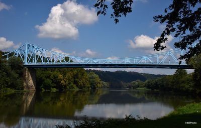
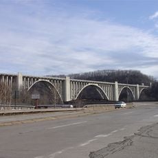
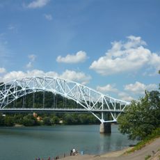
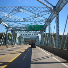
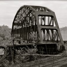
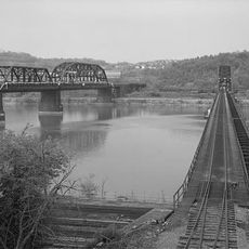
Boston Bridge, Cantilever road bridge in Allegheny County, Pennsylvania

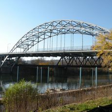
Boston Bridge is a cantilever structure that spans the Youghiogheny River, connecting Versailles with Elizabeth Township in Allegheny County. The bridge provides two vehicle lanes and pedestrian walkways, with original railings and protective barriers installed to shield the main trusses from traffic impact.

Fort Pitt Bridge Works built this metal cantilever structure in 1931 using a rivet-connected Warren truss design. The construction reflects engineering practices common in that era for crossing major river valleys in western Pennsylvania.

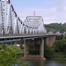
The bridge carries Pennsylvania Route 48, known as the Orange Belt, and marks a point along the Youghiogheny River Trail, a former railroad corridor. Today it remains a practical link between communities in this part of western Pennsylvania.

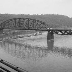
The bridge remains open for regular vehicle and pedestrian traffic, with protective barriers keeping both types of users safe. Being an active transportation route, expect normal traffic patterns throughout the day.

The structure features large arch-shaped bracing elements near its main towers and an unusually smooth curved top chord. These design details set it apart from other steel cantilever bridges built during the same period.

The community of curious travelers

AroundUs brings together thousands of curated places, local tips, and hidden gems, enriched daily by 60,000 contributors worldwide.

Start exploring
Location
Inception
1931
Official opening
1931
GPS coordinates
40.31280,-79.82830
Latest update
December 14, 2025 11:04
Around this place
Kennywood
United States of America

Kennywood

8.8 km
Steel Curtain
United States of America

Steel Curtain

8.7 km
Jack Rabbit
United States of America

Jack Rabbit

8.7 km
Sky Rocket
United States of America

Sky Rocket

8.8 km
Racer
United States of America

Racer

8.7 km
George Westinghouse Bridge
United States of America

George Westinghouse Bridge

8.9 km
United States of America

Round Hill Park

7.5 km
St. Mary's Church, McKeesport
United States of America

St. Mary's Church, McKeesport

4.9 km
Regis R. Malady Bridge
United States of America

Regis R. Malady Bridge

6.6 km
W.D. Mansfield Memorial Bridge
United States of America

W.D. Mansfield Memorial Bridge

6.1 km
Clairton-Glassport Bridge
United States of America

Clairton-Glassport Bridge

5 km
Jerome Street Bridge
United States of America

Jerome Street Bridge

5.5 km
Van Kirk Farm
United States of America

Van Kirk Farm

8.5 km
Elizabeth Locks & Dam
United States of America

Elizabeth Locks & Dam

8.1 km
McKeesport Connecting Railroad Bridge
United States of America

McKeesport Connecting Railroad Bridge

5.2 km
McKeesport-Duquesne Bridge
United States of America

McKeesport-Duquesne Bridge

5.2 km
Carnegie Free Library
United States of America

Carnegie Free Library

4.3 km
Union Railroad Clairton Bridge
United States of America

Union Railroad Clairton Bridge

3.9 km
PRR Port Perry Bridge
United States of America

PRR Port Perry Bridge

8.5 km
McKeesport National Bank
United States of America

McKeesport National Bank

5.1 km
First Methodist Episcopal Church of McKeesport
United States of America

First Methodist Episcopal Church of McKeesport

4.5 km
Hutchinson Farm (Elizabeth, Pennsylvania)
United States of America

Hutchinson Farm (Elizabeth, Pennsylvania)

8.7 km
Andrew and Jennie McFarlane House
United States of America

Andrew and Jennie McFarlane House

7.8 km
Sewickley Manor
United States of America

Sewickley Manor

7.8 km
Bowman Homestead
United States of America

Bowman Homestead

6.5 km
Jefferson Hills Public Library
United States of America

Jefferson Hills Public Library

8.7 km
Union Railroad Port Perry Bridge
United States of America

Union Railroad Port Perry Bridge

8.6 km
Family Funscape
United States of America

Family Funscape

8.9 km
Show the full map
« Boston Bridge - Cantilever road bridge in Allegheny County, Pennsylvania » is provided by Around Us (aroundus.com). Images and texts are derived from Wikimedia project under a Creative Commons license. You are allowed to copy, distribute, and modify copies of this page, under the conditions set by the license, as long as this note is clearly visible.

Discover hidden gems everywhere you go!

From secret cafés to breathtaking viewpoints, skip the crowded tourist spots and find places that match your style. Our app makes it easy with voice search, smart filtering, route optimization, and insider tips from travelers worldwide. Download now for the complete mobile experience.

Around Us App Screenshot

A unique approach to discovering new places

Le Figaro

All the places worth exploring

France Info

A tailor-made excursion in just a few clicks

20 Minutes

Around Us
Travel Guide & Maps
Download

Send to your phone

QR Code
1

Open the camera app on your mobile.

2

Point at the QR code with your camera. A notification will appear.

3

Tap the notification to open the link.