Charles C. Deam Wilderness Area

Log in to your account

AroundUs is a community-driven map of interesting places, built by curious explorers like you. It grows with every review, story, and photo you share.
Connect to save your favorite spots, contribute locations, and create personalized routes.
By continuing, you accept our Terms and Conditions and our Privacy Policy

Charles C. Deam Wilderness Area

Add to collection
Map
Suggest a change
Share

Charles C. Deam Wilderness Area, Wilderness area in Monroe County, Indiana.

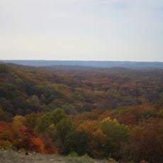
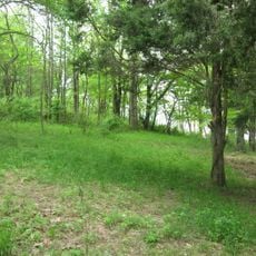
Charles C. Deam Wilderness Area is a large protected forest in Monroe County featuring dense hardwood stands of oak, hickory, and maple trees across rolling terrain and varied geology. The landscape includes hills, streams, and rock formations that create a visually changing environment as visitors move through the woods.

The land was used for farming for many decades before receiving federal protection in 1982 as part of the Hoosier National Forest. This shift from agricultural use to protected forest reflects a major change in how the region approached land management.

The area takes its name from Indiana's first State Forester, Charles C. Deam, who dedicated his life to forest conservation and plant study. Visitors walking through the trails can sense how this historical commitment to protecting woodlands continues to shape what they see today.

The area can be explored on 36 miles of marked hiking trails that also allow horseback riding, and wilderness camping is permitted following Leave No Trace practices. Visitors should plan to be self-sufficient since facilities are minimal and the area requires visitors to leave no impact on the environment.

The area features unusual geology with flat-topped ridges and streambeds filled with geodes, along with caves that reveal traces of ancient karst landscape. Its southern boundary borders Monroe Lake, Indiana's largest reservoir, creating an interesting contrast between wild forest and human-made water infrastructure.

Location: Monroe County

GPS coordinates: 39.03810,-86.35470

Latest update: December 10, 2025 20:07

Photos
Around this place
Brown County State Park
United States of America

Brown County State Park

11.5 km
Eskenazi Museum of Art
United States of America

Eskenazi Museum of Art

20.1 km
Hickory Ridge Fire Tower
United States of America

Hickory Ridge Fire Tower

2.9 km
Vinegar Hill Historic District
United States of America

Vinegar Hill Historic District

19.6 km
Weed Patch Hill
United States of America

Weed Patch Hill

18.6 km
Kirkwood Observatory
United States of America

Kirkwood Observatory

20.5 km
Wylie House
United States of America

Wylie House

20.5 km
Legg House
United States of America

Legg House

20.4 km
T. C. Steele State Historic Site
United States of America

T. C. Steele State Historic Site

10.4 km
Millen House
United States of America

Millen House

19.5 km
Princess Theatre
United States of America

Princess Theatre

20.5 km
Archives of Traditional Music
United States of America

Archives of Traditional Music

20.1 km
Sanshin Zen Community
United States of America

Sanshin Zen Community

18.8 km
Mathers Museum of World Cultures
United States of America

Mathers Museum of World Cultures

20.9 km
Madden School
United States of America

Madden School

21 km
Indiana University Auditorium
United States of America

Indiana University Auditorium

20.2 km
Cantol Wax Company Building
United States of America

Cantol Wax Company Building

21.1 km
Monroe Carnegie Library
United States of America

Monroe Carnegie Library

21 km
University Courts Historic District
United States of America

University Courts Historic District

20.7 km
Brown County Courthouse Historic District
United States of America

Brown County Courthouse Historic District

21.1 km
Joseph Mitchell House
United States of America

Joseph Mitchell House

17.3 km
Brown County Bridge No. 36
United States of America

Brown County Bridge No. 36

16.7 km
Thomas A. Hendricks House
United States of America

Thomas A. Hendricks House

19.8 km
Brown County Art Gallery
United States of America

Brown County Art Gallery

21.1 km
Buskirk-Chumley Theatre
United States of America

Buskirk-Chumley Theatre

21 km
Brown County Art Guild
United States of America

Brown County Art Guild

20.9 km
Kappa V Archaeological Site
United States of America

Kappa V Archaeological Site

4.7 km
Bakers Junction Haunted Train OPEN in Oct.
United States of America

Bakers Junction Haunted Train OPEN in Oct.

12.7 km
Show the full map
Reviews

Visited this place? Tap the stars to rate it and share your experience / photos with the community! Try now! You can cancel it anytime.

« Charles C. Deam Wilderness Area - Wilderness area in Monroe County, Indiana » is provided by Around Us (aroundus.com). Images and texts are derived from Wikimedia project under a Creative Commons license. You are allowed to copy, distribute, and modify copies of this page, under the conditions set by the license, as long as this note is clearly visible.

Discover hidden gems everywhere you go!

From secret cafés to breathtaking viewpoints, skip the crowded tourist spots and find places that match your style. Our app makes it easy with voice search, smart filtering, route optimization, and insider tips from travelers worldwide. Download now for the complete mobile experience.

Around Us App Screenshot

A unique approach to discovering new places

Le Figaro

All the places worth exploring

France Info

A tailor-made excursion in just a few clicks

20 Minutes