Enable Location

We need your location to show you interesting places around you

Discover nearby places

Find interesting locations and hidden gems around you

Precise directions

Get accurate directions and distances to places

Your location is never shared with other users. It's only used when you tap the location button.

Cedar Bluff Reservoir

Log in to your account

Start exploring — it's free

Trusted by 62,214 travelers worldwide

Continue with Google
Continue with Apple
or

We will send you a code to connect

By continuing, you accept our Terms and Conditions and our Privacy Policy

Check your inbox

We've sent a pincode in your inbox. Please enter the code below.

Cedar Bluff Reservoir

Cedar Bluff Reservoir, reservoir in Kansas, United States

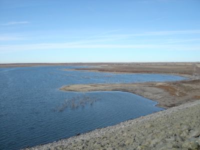
Cedar Bluff Reservoir is a large artificial lake in Trego County, Kansas, surrounded by limestone cliffs that form the landscape. The water flows in from the Smoky Hill River and stretches across a wide area with a prominent cliff face rising about 150 feet (46 meters) on the south shore.

The dam was constructed starting in 1949 and completed in 1951 to provide water for farming and towns during dry periods. A canal and fish hatchery were added in the late 1950s, but declining river flow caused irrigation to end in 1978 and the hatchery to close in 1983.

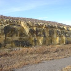
The name Cedar Bluff comes from the limestone cliffs that resemble a natural fortress rising above the water. Today, visitors use this place for quiet outdoor activities like fishing and photography, showing how the landscape shapes how people spend time here.

The reservoir is reached by driving about 13 miles (21 kilometers) south from Interstate 70 on Highway K-147. Cedar Bluff State Park offers campsites, boat ramps, showers, and cabins, with facilities for fishing, swimming, and various outdoor activities throughout the year.

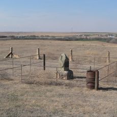
Threshing Machine Canyon south of the reservoir contains rock carvings and inscriptions from the 1800s made by soldiers and travelers. These historical marks document a wagon train attack in 1867 and offer a window into the region's past.

The community of curious travelers

AroundUs brings together thousands of curated places, local tips, and hidden gems, enriched daily by 60,000 contributors worldwide.

Start exploring
Location
GPS coordinates
38.78636,-99.77841
Latest update
February 7, 2026 11:40
Around this place
Fort Hays
United States of America

Fort Hays

38.8 km
Basilica of St. Fidelis
United States of America

Basilica of St. Fidelis

55 km
Cedar Bluff State Park
United States of America

Cedar Bluff State Park

1.4 km
Kansas Barbed Wire Museum
United States of America

Kansas Barbed Wire Museum

50 km
Lewis Field
United States of America

Lewis Field

39.1 km
Sternberg Museum of Natural History
United States of America

Sternberg Museum of Natural History

43.1 km
St. Joseph Catholic Church
United States of America

St. Joseph Catholic Church

61.5 km
Grainfield Opera House
United States of America

Grainfield Opera House

69.8 km
St. Joseph's Church and Parochial School
United States of America

St. Joseph's Church and Parochial School

39.9 km
Rush County Courthouse
United States of America

Rush County Courthouse

49.7 km
George Washington Carver Homestead Site
United States of America

George Washington Carver Homestead Site

53.6 km
Lane County Community High School
United States of America

Lane County Community High School

68.4 km
Shafer Barn
United States of America

Shafer Barn

71.7 km
Ness County Bank
United States of America

Ness County Bank

38.6 km
Lipp Barn
United States of America

Lipp Barn

39 km
Justus Bissing Jr. Historic District
United States of America

Justus Bissing Jr. Historic District

39.5 km
Ellis Congregational Church
United States of America

Ellis Congregational Church

25.5 km
Alexander & Anna Schwartz Farm
United States of America

Alexander & Anna Schwartz Farm

68.9 km
Hackberry Creek Bridge
United States of America

Hackberry Creek Bridge

68.6 km
Oxley Barn
United States of America

Oxley Barn

50.4 km
Lone Star School, District 64
United States of America

Lone Star School, District 64

56.6 km
Harry Keith Barn
United States of America

Harry Keith Barn

60 km
Collyer Downtown Historic District
United States of America

Collyer Downtown Historic District

40.7 km
Hays Aquatic Park
United States of America

Hays Aquatic Park

39.6 km
Nicodemus National Historic Site
United States of America

Nicodemus National Historic Site

68.9 km
Fox Pavilion
United States of America

Fox Pavilion

40.1 km
Strand Theatre
United States of America

Strand Theatre

40 km
Chestnut Street Historic District
United States of America

Chestnut Street Historic District

25.2 km
Show the full map
« Cedar Bluff Reservoir - reservoir in Kansas, United States » is provided by Around Us (aroundus.com). Images and texts are derived from Wikimedia project under a Creative Commons license. You are allowed to copy, distribute, and modify copies of this page, under the conditions set by the license, as long as this note is clearly visible.

Discover hidden gems everywhere you go!

From secret cafés to breathtaking viewpoints, skip the crowded tourist spots and find places that match your style. Our app makes it easy with voice search, smart filtering, route optimization, and insider tips from travelers worldwide. Download now for the complete mobile experience.

Around Us App Screenshot

A unique approach to discovering new places

Le Figaro

All the places worth exploring

France Info

A tailor-made excursion in just a few clicks

20 Minutes

Around Us
Travel Guide & Maps
Download

Send to your phone

QR Code
1

Open the camera app on your mobile.

2

Point at the QR code with your camera. A notification will appear.

3

Tap the notification to open the link.