Enable Location

We need your location to show you interesting places around you

Discover nearby places

Find interesting locations and hidden gems around you

Precise directions

Get accurate directions and distances to places

Your location is never shared with other users. It's only used when you tap the location button.

Fort Hays

Log in to your account

Start exploring — it's free

Trusted by 62,214 travelers worldwide

Continue with Google
Continue with Apple
or

We will send you a code to connect

By continuing, you accept our Terms and Conditions and our Privacy Policy

Check your inbox

We've sent a pincode in your inbox. Please enter the code below.

Fort Hays, Military fort in Kansas, United States

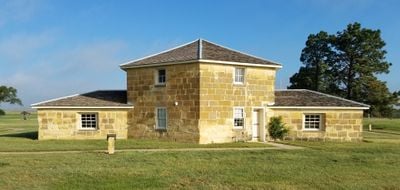
Fort Hays is a military fort in Kansas that preserves four original buildings from the 19th century, including a blockhouse, guardhouse, and officers' quarters along the former railway line. These structures stand on open grounds that once served as a base for soldiers stationed on the Great Plains.

The installation was founded in 1865 as Fort Fletcher and moved to its present location two years later to protect stagecoach routes and railway workers during westward expansion. Military units remained stationed here until 1889, when the frontier was no longer contested.

Soldiers from different regiments, including African American units, made this installation a place where military traditions from across the country came together during frontier operations. Visitors today can walk through officers' quarters and see how daily routines were organized according to rank and duty assignments.

The Kansas Historical Society manages the grounds as a state historic site and offers guided walks through the preserved buildings on most days of the week. Visitors can see the structures best during daylight hours, as the interiors rely on natural light.

Well-known figures from frontier times, including Wild Bill Hickok and Buffalo Bill Cody, passed through the installation during its active years. George Custer directed operations from here for a period before being reassigned to other posts.

The community of curious travelers

AroundUs brings together thousands of curated places, local tips, and hidden gems, enriched daily by 60,000 contributors worldwide.

Start exploring
Location
Inception
1867
GPS coordinates
38.86170,-99.34220
Latest update
December 20, 2025 14:48
Around this place
Wilson Lake
United States of America

Wilson Lake

68.6 km
Basilica of St. Fidelis
United States of America

Basilica of St. Fidelis

16.6 km
Pawnee Rock
United States of America

Pawnee Rock

72.8 km
Cedar Bluff Reservoir
United States of America

Cedar Bluff Reservoir

38.8 km
Cedar Bluff State Park
United States of America

Cedar Bluff State Park

38.5 km
Kansas Barbed Wire Museum
United States of America

Kansas Barbed Wire Museum

37.6 km
Lewis Field
United States of America

Lewis Field

584 m
Great Bend Army Airfield
United States of America

Great Bend Army Airfield

70.8 km
Sternberg Museum of Natural History
United States of America

Sternberg Museum of Natural History

4.8 km
Dream Theater
United States of America

Dream Theater

41.9 km
St. Joseph Catholic Church
United States of America

St. Joseph Catholic Church

55.1 km
St. Joseph's Church and Parochial School
United States of America

St. Joseph's Church and Parochial School

1.7 km
Rush County Courthouse
United States of America

Rush County Courthouse

37 km
Bridge 650
United States of America

Bridge 650

62.2 km
Paradise Water Tower
United States of America

Paradise Water Tower

46.7 km
Natoma Presbyterian Church
United States of America

Natoma Presbyterian Church

45.9 km
Rooks County Courthouse
United States of America

Rooks County Courthouse

64.4 km
Ness County Bank
United States of America

Ness County Bank

66.7 km
Lipp Barn
United States of America

Lipp Barn

68.9 km
Justus Bissing Jr. Historic District
United States of America

Justus Bissing Jr. Historic District

1.6 km
Ellis Congregational Church
United States of America

Ellis Congregational Church

20.8 km
Lone Star School, District 64
United States of America

Lone Star School, District 64

39.1 km
Collyer Downtown Historic District
United States of America

Collyer Downtown Historic District

70 km
Hays Aquatic Park
United States of America

Hays Aquatic Park

959 m
Nicodemus National Historic Site
United States of America

Nicodemus National Historic Site

63.6 km
Fox Pavilion
United States of America

Fox Pavilion

1.6 km
Strand Theatre
United States of America

Strand Theatre

1.6 km
Chestnut Street Historic District
United States of America

Chestnut Street Historic District

20.7 km
Show the full map
« Fort Hays - Military fort in Kansas, United States » is provided by Around Us (aroundus.com). Images and texts are derived from Wikimedia project under a Creative Commons license. You are allowed to copy, distribute, and modify copies of this page, under the conditions set by the license, as long as this note is clearly visible.

Discover hidden gems everywhere you go!

From secret cafés to breathtaking viewpoints, skip the crowded tourist spots and find places that match your style. Our app makes it easy with voice search, smart filtering, route optimization, and insider tips from travelers worldwide. Download now for the complete mobile experience.

Around Us App Screenshot

A unique approach to discovering new places

Le Figaro

All the places worth exploring

France Info

A tailor-made excursion in just a few clicks

20 Minutes

Around Us
Travel Guide & Maps
Download

Send to your phone

QR Code
1

Open the camera app on your mobile.

2

Point at the QR code with your camera. A notification will appear.

3

Tap the notification to open the link.