Enable Location

We need your location to show you interesting places around you

Discover nearby places

Find interesting locations and hidden gems around you

Precise directions

Get accurate directions and distances to places

Your location is never shared with other users. It's only used when you tap the location button.

Pawnee Rock

Log in to your account

Start exploring — it's free

Trusted by 65,434 travelers worldwide

Continue with Google
Continue with Apple
or

We will send you a code to connect

By continuing, you accept our Terms and Conditions and our Privacy Policy

Check your inbox

We've sent a pincode in your inbox. Please enter the code below.

Discussion Reviews 1 Photos
4.7k Popularity

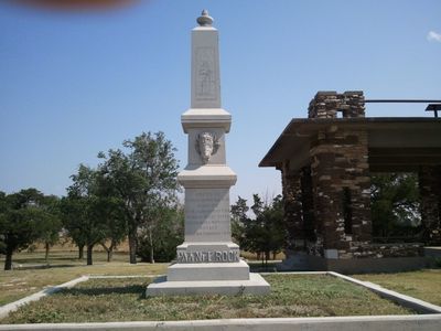
Pawnee Rock, Rock formation near Santa Fe Trail, Kansas, United States

Pawnee Rock is a sandstone formation that rises above the flat grasslands of Barton County, Kansas, near the route of the old Santa Fe Trail. At the top stands a small monument, and at the base there is a covered building used for picnicking.

Indigenous tribes used this high point to watch over buffalo herds and observe travelers long before the Santa Fe Trail became a major western route in the 19th century. In 1909, Kansas officially recognized the site as historic, largely because a women's group called the Woman's Kansas Day Club campaigned to protect it.

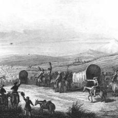
Pawnee Rock served as a reference point for wagon trains crossing the open plains, visible from a long distance in every direction. Travelers would stop here to rest, look out over the land, and carve their names into the soft sandstone.

The site is easy to reach by car and a short path leads up to the top, making it accessible for most visitors. Going in the early morning or late afternoon is a good idea because the location is open and exposed, with very little shade.

The rock was once much larger, but it was significantly worn down during the 19th century as people cut pieces from it to use as building stone for local structures. What visitors see today is only a portion of what early travelers on the trail would have recognized.

The community of curious travelers

AroundUs brings together thousands of curated places, local tips, and hidden gems, enriched daily by 60,000 contributors worldwide.

Start exploring
Location
GPS coordinates
38.27210,-98.98148
Latest update
March 3, 2026 08:14
Around this place
Fort Hays
United States of America

Fort Hays

72.8 km
Basilica of St. Fidelis
United States of America

Basilica of St. Fidelis

66.7 km
Brenham
United States of America

Brenham

78.4 km
Quivira National Wildlife Refuge
United States of America

Quivira National Wildlife Refuge

42.5 km
Kansas Barbed Wire Museum
United States of America

Kansas Barbed Wire Museum

40.3 km
Lewis Field
United States of America

Lewis Field

73.1 km
Great Bend Army Airfield
United States of America

Great Bend Army Airfield

13.1 km
Sternberg Museum of Natural History
United States of America

Sternberg Museum of Natural History

74.1 km
Dream Theater
United States of America

Dream Theater

69.7 km
St. Joseph's Church and Parochial School
United States of America

St. Joseph's Church and Parochial School

73.7 km
Stafford Reformed Presbyterian Church
United States of America

Stafford Reformed Presbyterian Church

47.6 km
Rush County Courthouse
United States of America

Rush County Courthouse

40.6 km
Gano Grain Elevator and Scale House
United States of America

Gano Grain Elevator and Scale House

61.1 km
Hotel Roberts
United States of America

Hotel Roberts

73.2 km
S.P. Gebhart House
United States of America

S.P. Gebhart House

72.8 km
Bridge 650
United States of America

Bridge 650

53.3 km
Nagel House
United States of America

Nagel House

19.3 km
Farmers National Bank
United States of America

Farmers National Bank

48.1 km
Rice County Courthouse
United States of America

Rice County Courthouse

68.5 km
Stafford First United Methodist Church
United States of America

Stafford First United Methodist Church

47.8 km
Justus Bissing Jr. Historic District
United States of America

Justus Bissing Jr. Historic District

73.9 km
Pratt County Courthouse
United States of America

Pratt County Courthouse

73.2 km
Santa Fe Trail
United States of America

Santa Fe Trail

49.8 km
Earl H. Ellis VFW Post No. 1362
United States of America

Earl H. Ellis VFW Post No. 1362

73.1 km
Fort Larned National Historic Site
United States of America

Fort Larned National Historic Site

22.9 km
St. Mary's Catholic Church
United States of America

St. Mary's Catholic Church

66.1 km
Fox Pavilion
United States of America

Fox Pavilion

73.4 km
Strand Theatre
United States of America

Strand Theatre

73.4 km
Show the full map
Reviews
Share your experience

No review yet

Discussions
Start a discussion...

No discussion yet

« Pawnee Rock - Rock formation near Santa Fe Trail, Kansas, United States » is provided by Around Us (aroundus.com). Images and texts are derived from Wikimedia project under a Creative Commons license. You are allowed to copy, distribute, and modify copies of this page, under the conditions set by the license, as long as this note is clearly visible.

Discover hidden gems everywhere you go!

From secret cafés to breathtaking viewpoints, skip the crowded tourist spots and find places that match your style. Our app makes it easy with voice search, smart filtering, route optimization, and insider tips from travelers worldwide. Download now for the complete mobile experience.

Around Us App Screenshot

A unique approach to discovering new places

Le Figaro

All the places worth exploring

France Info

A tailor-made excursion in just a few clicks

20 Minutes

Around Us
Travel Guide & Maps
Download

Send to your phone

QR Code
1

Open the camera app on your mobile.

2

Point at the QR code with your camera. A notification will appear.

3

Tap the notification to open the link.