Enable Location

We need your location to show you interesting places around you

Discover nearby places

Find interesting locations and hidden gems around you

Precise directions

Get accurate directions and distances to places

Your location is never shared with other users. It's only used when you tap the location button.

Cedar Creek Ecosystem Science Reserve

Log in to your account

Start exploring — it's free

Trusted by 62,089 travelers worldwide

Continue with Google
Continue with Apple
or

We will send you a code to connect

By continuing, you accept our Terms and Conditions and our Privacy Policy

Check your inbox

We've sent a pincode in your inbox. Please enter the code below.

Cedar Creek Ecosystem Science Reserve

Cedar Creek Ecosystem Science Reserve, Research facility and natural landmark in East Bethel, United States.

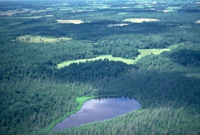
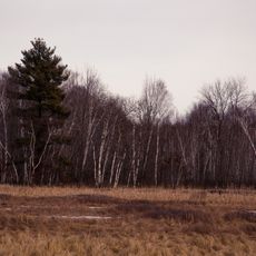
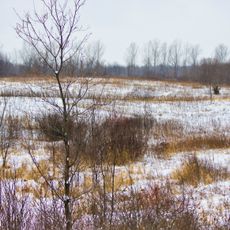
Cedar Creek Ecosystem Science Reserve is a large natural area in East Bethel featuring forests, grasslands, and wetlands with over 900 research plots spread across the property. The University of Minnesota operates this facility to study how ecosystems work and change over time.

The University of Minnesota established this research center in 1942 to conduct long-term studies on ecosystems. The National Park Service designated it as a National Natural Landmark in 1975, recognizing its scientific importance.

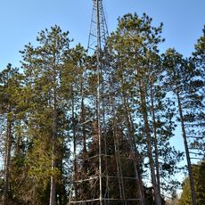
The name comes from the waterways and vegetation that shape the land. Researchers and students regularly walk through the property to observe and document what grows and lives here.

Visitors can explore the Lindeman Research and Discovery Center with guidance, located on Fawn Lake Drive NE in East Bethel. It is important to contact the center in advance to arrange access and learn what activities are available during your visit.

The property sits where three distinct forest types and habitats naturally meet and overlap. This rare location supports an exceptional range of animals, including many mammal species and hundreds of bird species.

The community of curious travelers

AroundUs brings together thousands of curated places, local tips, and hidden gems, enriched daily by 60,000 contributors worldwide.

Start exploring
Location
Location
Inception
1942
GPS coordinates
45.40860,-93.20080
Latest update
December 8, 2025 21:02
Around this place
Coon Rapids High School
United States of America

Coon Rapids High School

27.1 km
The Crossing Church
United States of America

The Crossing Church

31 km
Carlos Avery Game Farm
United States of America

Carlos Avery Game Farm

14.6 km
Swedish Evangelical Lutheran Church
United States of America

Swedish Evangelical Lutheran Church

12.8 km
Anoka-Champlin Mississippi River Bridge
United States of America

Anoka-Champlin Mississippi River Bridge

28.6 km
Windego Park Auditorium/Open Air Theater
United States of America

Windego Park Auditorium/Open Air Theater

27.9 km
Betty Adkins Bridge
United States of America

Betty Adkins Bridge

31 km
Svenska Mission Kyrka I Sodre Maple Ridge
United States of America

Svenska Mission Kyrka I Sodre Maple Ridge

30.3 km
Colonial Hall and Masonic Lodge No. 30
United States of America

Colonial Hall and Masonic Lodge No. 30

27.7 km
Crescent Grange Hall No. 512
United States of America

Crescent Grange Hall No. 512

8.4 km
Sparre Barn
United States of America

Sparre Barn

22.5 km
Champlin Library
United States of America

Champlin Library

30.1 km
Moody Barn
United States of America

Moody Barn

28.4 km
Isanti County Courthouse
United States of America

Isanti County Courthouse

18.2 km
Heman L. Ticknor House
United States of America

Heman L. Ticknor House

28.1 km
St. John's Lutheran Church
United States of America

St. John's Lutheran Church

12.2 km
Parrish Avenue Bridge
United States of America

Parrish Avenue Bridge

30.9 km
Henry G. Leathers House
United States of America

Henry G. Leathers House

12.6 km
Babcock Memorial Park
United States of America

Babcock Memorial Park

30.9 km
Shaw–Hammons House
United States of America

Shaw–Hammons House

28 km
Center City Historic District
United States of America

Center City Historic District

30.1 km
Goose Creek
United States of America

Goose Creek

27 km
District No. 28 School
United States of America

District No. 28 School

25.4 km
Oliver H. Kelley Homestead
United States of America

Oliver H. Kelley Homestead

31.1 km
Porter Kelsey House
United States of America

Porter Kelsey House

23.2 km
Carlos Avery State Wildlife Management Area
United States of America

Carlos Avery State Wildlife Management Area

13.6 km
Elm Creek Park Reserve
United States of America

Elm Creek Park Reserve

30.9 km
Cambridge Lookout Tower
United States of America

Cambridge Lookout Tower

17.4 km
Show the full map
« Cedar Creek Ecosystem Science Reserve - Research facility and natural landmark in East Bethel, United States » is provided by Around Us (aroundus.com). Images and texts are derived from Wikimedia project under a Creative Commons license. You are allowed to copy, distribute, and modify copies of this page, under the conditions set by the license, as long as this note is clearly visible.

Discover hidden gems everywhere you go!

From secret cafés to breathtaking viewpoints, skip the crowded tourist spots and find places that match your style. Our app makes it easy with voice search, smart filtering, route optimization, and insider tips from travelers worldwide. Download now for the complete mobile experience.

Around Us App Screenshot

A unique approach to discovering new places

Le Figaro

All the places worth exploring

France Info

A tailor-made excursion in just a few clicks

20 Minutes

Around Us
Travel Guide & Maps
Download

Send to your phone

QR Code
1

Open the camera app on your mobile.

2

Point at the QR code with your camera. A notification will appear.

3

Tap the notification to open the link.