·

Enable Location

We need your location to show you interesting places around you

Discover nearby places

Find interesting locations and hidden gems around you

Precise directions

Get accurate directions and distances to places

Your location is never shared with other users. It's only used when you tap the location button.

Chilhowee Dam

Log in to your account

Start exploring — it's free

Trusted by 62,749 travelers worldwide

Continue with Google
Continue with Apple
or

We will send you a code to connect

By continuing, you accept our Terms and Conditions and our Privacy Policy

Check your inbox

We've sent a pincode in your inbox. Please enter the code below.

Chilhowee Dam, dam in Monroe County, Tennessee, United States of America

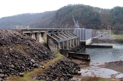
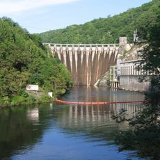
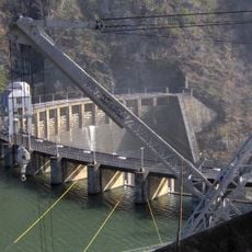
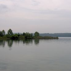
Chilhowee Dam is a concrete structure spanning the Little Tennessee River that impounds a reservoir covering over 1,700 acres. The facility houses three Kaplan turbines that generate about 48 megawatts of electricity for the surrounding region and nearby industries.

The dam was built between 1955 and 1957 primarily to generate electricity for a nearby aluminum factory. Its listing on the National Register of Historic Places reflects its significance as part of the region's mid-20th century industrial development and energy infrastructure.

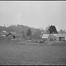
The dam represents regional industrial progress and is woven into local identity as a symbol of how communities harness water for power. Visitors walking along the shoreline encounter a landscape shaped by human engineering that has become part of everyday life here.

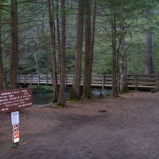
The dam is easily accessible by road with parking nearby for visitors. Be aware of property boundaries and local rules when exploring, and stay alert for wildlife including bears and copperhead snakes in the surrounding areas.

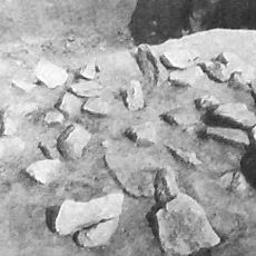
When water levels drop, the remains of an old bridge carrying US Highway 129 become visible beneath the surface. A dewatered section of the Little Tennessee River downstream features unusual rock formations with holes that may have been used by Native peoples to grind food.

The community of curious travelers

AroundUs brings together thousands of curated places, local tips, and hidden gems, enriched daily by 60,000 contributors worldwide.

Start exploring
Location
Location
Inception
1955
Elevation above the sea
249 m
Length
452 m
GPS coordinates
35.54556,-84.05028
Latest update
February 7, 2026 11:00
Around this place
Cheoah Dam
United States of America

Cheoah Dam

15 km
Fort Loudoun
United States of America

Fort Loudoun

15 km
Joyce Kilmer Memorial Forest
United States of America

Joyce Kilmer Memorial Forest

20.3 km
Chota
United States of America

Chota

7.4 km
Abrams Falls Trail
United States of America

Abrams Falls Trail

18.8 km
Gregory Bald
United States of America

Gregory Bald

16.9 km
Tellico Blockhouse
United States of America

Tellico Blockhouse

15.1 km
Joyce Kilmer-Slickrock Wilderness
United States of America

Joyce Kilmer-Slickrock Wilderness

20.3 km
Calderwood Dam
United States of America

Calderwood Dam

8.7 km
Morganton, Tennessee
United States of America

Morganton, Tennessee

19.4 km
Citico Creek Wilderness
United States of America

Citico Creek Wilderness

15.7 km
Tomotley
United States of America

Tomotley

12.6 km
Icehouse Bottom
United States of America

Icehouse Bottom

14.4 km
Calderwood
United States of America

Calderwood

7.7 km
Shuckstack
United States of America

Shuckstack

22.3 km
Clover Hill Mill
United States of America

Clover Hill Mill

17.7 km
Tapoco Lodge Historic District
United States of America

Tapoco Lodge Historic District

15.3 km
United States of America

Fort Loudoun State Park

15.6 km
Sandy Springs Park
United States of America

Sandy Springs Park

22.7 km
Craigs Chapel AME Zion Church
United States of America

Craigs Chapel AME Zion Church

16 km
William H. Griffitts House
United States of America

William H. Griffitts House

21.5 km
Sequoyah Birthplace Museum
United States of America

Sequoyah Birthplace Museum

15.5 km
John M. Rorex House
United States of America

John M. Rorex House

13.5 km
Cades Cove Missionary Baptist Church
United States of America

Cades Cove Missionary Baptist Church

21.4 km
Look Rock Observation Tower
United States of America

Look Rock Observation Tower

13.7 km
Cades Cove Methodist Church
United States of America

Cades Cove Methodist Church

22.2 km
Cades Cove Primitive Baptist Church
United States of America

Cades Cove Primitive Baptist Church

22.3 km
Cades Cove Visitor Center
United States of America

Cades Cove Visitor Center

19.3 km
Show the full map
« Chilhowee Dam - dam in Monroe County, Tennessee, United States of America » is provided by Around Us (aroundus.com). Images and texts are derived from Wikimedia project under a Creative Commons license. You are allowed to copy, distribute, and modify copies of this page, under the conditions set by the license, as long as this note is clearly visible.

Discover hidden gems everywhere you go!

From secret cafés to breathtaking viewpoints, skip the crowded tourist spots and find places that match your style. Our app makes it easy with voice search, smart filtering, route optimization, and insider tips from travelers worldwide. Download now for the complete mobile experience.

Around Us App Screenshot

A unique approach to discovering new places

Le Figaro

All the places worth exploring

France Info

A tailor-made excursion in just a few clicks

20 Minutes

Around Us
Travel Guide & Maps
Download

Send to your phone

QR Code
1

Open the camera app on your mobile.

2

Point at the QR code with your camera. A notification will appear.

3

Tap the notification to open the link.