Calderwood Dam

Log in to your account

AroundUs is a community-driven map of interesting places, built by curious explorers like you. It grows with every review, story, and photo you share.
Connect to save your favorite spots, contribute locations, and create personalized routes.
By continuing, you accept our Terms and Conditions and our Privacy Policy
Add to collection
Map
Suggest a change
Share

Calderwood Dam, Hydroelectric arch dam in Monroe County, Tennessee, United States.

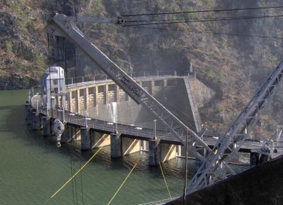
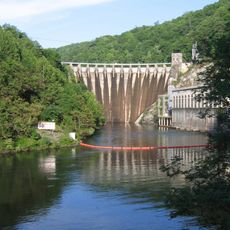
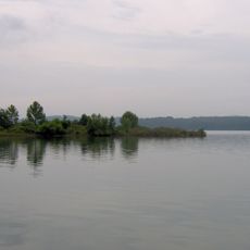
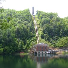
Calderwood Dam is a concrete arch structure completed in 1930 that spans the Little Tennessee River and stores water for power generation. The facility operates through a tunnel system that conveys water from the reservoir to a powerhouse positioned downstream.

Aluminum Company of America built the dam in 1930 to supply power for aluminum smelting operations in the region. The Tennessee Valley Authority later took over operations and integrated it into the broader regional system for electricity production and river management.

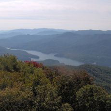
The structure represents an important piece of regional industrial development when electricity was still being distributed through private enterprises. Today, visitors can see how this engineering achievement shaped the landscape and energy production patterns of the valley.

The structure can be viewed from roads in the area, but visitors should be aware of uneven terrain and stay safely back from edges. Wear sturdy footwear and exercise caution around the water system, as this is an active power-generating facility.

The powerhouse sits nearly 2 kilometers downstream and is fed by a tunnel carved directly through the mountain. This hidden pipeline represents the engineering sophistication of private industrial construction at a time when large-scale infrastructure was not yet managed by government agencies.

Location: Tennessee

Location: Monroe County

Elevation above the sea: 331 m

GPS coordinates: 35.49250,-83.97944

Latest update: December 10, 2025 20:01

Photos
Around this place
Show the full map
Fontana Lake
United States of America

Fontana Lake

17.8 km
Cheoah Dam
United States of America

Cheoah Dam

6.3 km
Fort Loudoun
United States of America

Fort Loudoun

23.3 km
Joyce Kilmer Memorial Forest
United States of America

Joyce Kilmer Memorial Forest

13.2 km
Chota
United States of America

Chota

15.4 km
Abrams Falls Trail
United States of America

Abrams Falls Trail

16 km
Gregory Bald
United States of America

Gregory Bald

10.7 km
Tellico Blockhouse
United States of America

Tellico Blockhouse

23.5 km
Joyce Kilmer-Slickrock Wilderness
United States of America

Joyce Kilmer-Slickrock Wilderness

13.2 km
Citico Creek Wilderness
United States of America

Citico Creek Wilderness

11.7 km
Tomotley
United States of America

Tomotley

20.6 km
Santeetlah Dam
United States of America

Santeetlah Dam

15.9 km
Icehouse Bottom
United States of America

Icehouse Bottom

22.8 km
Shuckstack
United States of America

Shuckstack

14.9 km
Clover Hill Mill
United States of America

Clover Hill Mill

24.4 km
Tapoco Lodge Historic District
United States of America

Tapoco Lodge Historic District

6.7 km
Fort Loudoun State Park
United States of America

Fort Loudoun State Park

23.9 km
Sequoyah Birthplace Museum
United States of America

Sequoyah Birthplace Museum

23.5 km
Graham County Courthouse
United States of America

Graham County Courthouse

24.6 km
John M. Rorex House
United States of America

John M. Rorex House

21.7 km
Cades Cove Missionary Baptist Church
United States of America

Cades Cove Missionary Baptist Church

18.9 km
Look Rock Observation Tower
United States of America

Look Rock Observation Tower

15.9 km
Cades Cove Methodist Church
United States of America

Cades Cove Methodist Church

19.5 km
Cades Cove Primitive Baptist Church
United States of America

Cades Cove Primitive Baptist Church

19.3 km
Cades Cove Visitor Center
United States of America

Cades Cove Visitor Center

16.1 km
Carter Shields Cabin
United States of America

Carter Shields Cabin

19.6 km
Elijah Oliver Place
United States of America

Elijah Oliver Place

16.5 km
Lake Santeetlah
United States of America

Lake Santeetlah

18.8 km
Show the full map
Reviews

Visited this place? Tap the stars to rate it and share your experience / photos with the community! Try now! You can cancel it anytime.

« Calderwood Dam - Hydroelectric arch dam in Monroe County, Tennessee, United States » is provided by Around Us (aroundus.com). Images and texts are derived from Wikimedia project under a Creative Commons license. You are allowed to copy, distribute, and modify copies of this page, under the conditions set by the license, as long as this note is clearly visible.

Discover hidden gems everywhere you go!

From secret cafés to breathtaking viewpoints, skip the crowded tourist spots and find places that match your style. Our app makes it easy with voice search, smart filtering, route optimization, and insider tips from travelers worldwide. Download now for the complete mobile experience.

Around Us App Screenshot

A unique approach to discovering new places

Le Figaro

All the places worth exploring

France Info

A tailor-made excursion in just a few clicks

20 Minutes