Chest opened
+${chestReward.xp} XP
Explorer
NOUVEAU ×${chestReward.collectible.quantity}
tapez pour fermer
Chest locked

Open chests in the app

Around Us is built for your phone — chests unlock when you walk, explore and capture nearby places.

Enable Location

We need your location to show you interesting places around you

Discover nearby places

Find interesting locations and hidden gems around you

Precise directions

Get accurate directions and distances to places

Your location is never shared with other users. It's only used when you tap the location button.

Coosawattee River

Log in to your account

Start exploring — it's free

Trusted by 72,880 travelers worldwide

Continue with Google
Continue with Apple
or

We will send you a code to connect

By continuing, you accept our Terms and Conditions and our Privacy Policy

Check your inbox

We've sent a pincode in your inbox. Please enter the code below.

Coosawattee River
Discussion Reviews 1 Photos
10.3k Popularity

Coosawattee River, Major river system in northwestern Georgia, United States.

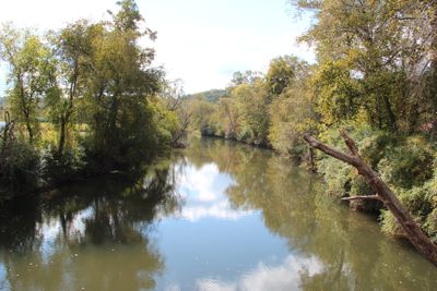
The Coosawattee River is a river in northwestern Georgia that begins where the Ellijay and Cartecay rivers meet and flows toward the Oostanaula River. It runs through wooded, hilly land and passes through several counties before reaching flatter terrain downstream.

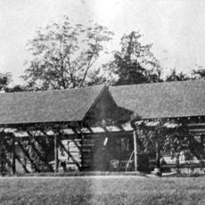
The Coosawattee valley was home to Cherokee communities for generations, serving as a central corridor for settlement and trade. In 1838, those communities were forcibly removed during the event known as the Trail of Tears, which reshaped the entire region.

The name Coosawattee comes from the Cherokee language, and its meaning is tied to the communities that once lived along these banks. Visitors walking the riverside can still notice traces of that presence in place names and local storytelling.

The river can be accessed from several points along its course, and it works well for both hiking and paddling. Water temperatures stay cool throughout the year, so layering is a good idea regardless of the season.

Carters Dam, built across this river, is the tallest earthen dam east of the Mississippi River, and it turned a stretch of the valley into a reservoir. Parts of the original riverbed now sit underwater, making the current landscape quite different from what it looked like before the dam was built.

The community of curious travelers

AroundUs brings together thousands of curated places, local tips, and hidden gems, enriched daily by 60,000 contributors worldwide.

Start exploring
Location
GPS coordinates
34.54370,-84.90272
Latest update
March 3, 2026 10:12
Around this place
Berry College
United States of America

Berry College

38.8 km
New Echota
United States of America

New Echota

763 m
Fort Mountain State Park
United States of America

Fort Mountain State Park

30.5 km
Carters Lake
United States of America

Carters Lake

25.7 km
Chief Vann House Historic Site
United States of America

Chief Vann House Historic Site

25.5 km
Tellus Science Museum
United States of America

Tellus Science Museum

35.7 km
Oak Hill & The Martha Berry Museum
United States of America

Oak Hill & The Martha Berry Museum

39.1 km
Chieftains Museum
United States of America

Chieftains Museum

38.5 km
Resaca Confederate Cemetery
United States of America

Resaca Confederate Cemetery

7.9 km
Savoy Automobile Museum
United States of America

Savoy Automobile Museum

38.5 km
Prater's Mill
United States of America

Prater's Mill

39.2 km
Walker County Courthouse
United States of America

Walker County Courthouse

38.9 km
United States of America

Jackson Hill

39.1 km
Blossom Hill
United States of America

Blossom Hill

38.6 km
Masonic Lodge No. 238
United States of America

Masonic Lodge No. 238

25.4 km
Murray County Courthouse
United States of America

Murray County Courthouse

27.6 km
Dalton Commercial Historic District
United States of America

Dalton Commercial Historic District

26 km
Corra White Harris House, Study, and Chapel
United States of America

Corra White Harris House, Study, and Chapel

23.3 km
Chattooga Academy
United States of America

Chattooga Academy

39.2 km
Red Apple Barn
United States of America

Red Apple Barn

37.9 km
William Taylor House
United States of America

William Taylor House

5.6 km
Wright Hotel
United States of America

Wright Hotel

27.8 km
Thomas A. Berry House
United States of America

Thomas A. Berry House

26.4 km
United States of America

Penn Place

37.1 km
Ainsworth E. Blunt House
United States of America

Ainsworth E. Blunt House

25.7 km
Resaca Battlefield State Historic Site
United States of America

Resaca Battlefield State Historic Site

7.7 km
Movies at Mount Berry Square
United States of America

Movies at Mount Berry Square

36.6 km
Adairsville Historic District
United States of America

Adairsville Historic District

19.9 km
Show the full map
Reviews
Share your experience

No review yet

Discussions
Start a discussion...

No discussion yet

« Coosawattee River - Major river system in northwestern Georgia, United States » is provided by Around Us (aroundus.com). Images and texts are derived from Wikimedia project under a Creative Commons license. You are allowed to copy, distribute, and modify copies of this page, under the conditions set by the license, as long as this note is clearly visible.

Discover hidden gems everywhere you go!

From secret cafés to breathtaking viewpoints, skip the crowded tourist spots and find places that match your style. Our app makes it easy with voice search, smart filtering, route optimization, and insider tips from travelers worldwide. Download now for the complete mobile experience.

Around Us App Screenshot

A unique approach to discovering new places

Le Figaro

All the places worth exploring

France Info

A tailor-made excursion in just a few clicks

20 Minutes

Around Us
Travel Guide & Maps
Download

Send to your phone

QR Code
1

Open the camera app on your mobile.

2

Point at the QR code with your camera. A notification will appear.

3

Tap the notification to open the link.